Field Data from Expeditions of the Meteorological Institute UHH


Topics
- Access
- Description
- Parameters
- Coverage, spatial and temporal resolution
- Data quality
- Contact person
- References
- Data citation
Access
UNRESTRICTED:
RESTRICTED:This link to the data set is only available for a restricted user group. The data set is only accessible in CEN/MPI net or accessible from external nets with a customer account. Please contact ICDC if you would like to access this data from outside the network.
- Data access via file system: /data/icdc/atmosphere/mi_feldexperimente
Description
The Physical Meteorology Division of the Meteorological Institute is regularly conducting or taking part in field experiments with strong focus on high latitudes. Measurements are performed by aircraft, buoys or radiosondes, and at land, ship and ice stations.
Published data sets incorporate aircraft measurements of turbulent fluxes and standard meteorological parameters of high temporal and spatial resolution. These measurements are supported by frequent radiosonde ascents and station and ship data in the according region. Another group of data sets consists of measurements by autonomous buoys of different complexity on sea ice and ocean.
The datasets are independent (except some radiosonde data), that means the data were not used for operational weather predictions or reanalyses.
The field phases of the experiment had durations of one to four weeks. Radiosondes were launched 3- to 6-hourly during these periods. Aircraft data contain up to ten missions per experiment. The lifespan of the autonomous buoys differ from few days to more than one year, depending on ice conditions and battery duration. Details are listed by platform:
Radiosonde
Radiosondes were launched at stations or along the routes of research vessels. Soundings were mostly made 3-hourly with higher frequencies during interesting synoptic conditions. Gaps are caused by severe weather or port calls of the vessels. The sampling frequency and the vertical resolutions of the soundings depend on the radiosonde models and the applied data processing.
Aircraft
Single flight missions cover areas of 200 x 200 km and had durations of about two hours. The flight patterns consist of horizontal and vertical (profile) sections. The aircraft speed was 100 ms-1 and the sampling frequency was 100 Hz. The provided data has a temporal resolution of 1 Hz.
Buoys
Buoy data is provided 1-hourly (CALIB, XAN) and 3-hourly (PAWS). Buoys were deployed in regular arrays with distances up to 100 km. Trajectories of single buoys depend on ice drift and surface ocean currents respectively.
Experiments
The following experiments are included:
- ACSYS (1998, 2003),
- ALKOR (2000, 2001),
- ARKTIS (1988, 1991, 1993),
- ASTEX (1992),
- BASIS (1998, 2001),
- DAMOCLES (2007, 2008),
- FGGE (1979),
- FRAMZY (1999, 2002, 2007, 2008, 2009),
- FRONTEX (1989),
- KONTROL (1984,1985),
- KONTUR (1981),
- LOFZY (2005).
| Exp.No. | Data set name | Data set information | DSD/ FR | CERA | ICDC |
|---|---|---|---|---|---|
| 23 | FRAMZY2009_calib_buoy | position, temperature and pressure data of 6 autonomous drifting ice buoys, 02/10/2009-18/02/2010, Fram Strait | - | CERA | FTP |
| 22 | FRAMZY2008_calib_buoy | position, temperature and pressure data of 6 autonomous drifting ice buoys, 20/01-28/02/2008, Fram Strait | FR | CERA | FTP |
| 21 | DAMOCLES2008_paws_buoy | position, temperature, pressure and wind data of 9 autonomous drifting ice buoys, 14/04/2008-22/02/2011, Arctic Ocean | - | CERA | FTP |
| 20 | DAMOCLES2007_calib_buoy | position, temperature and pressure data of 16 autonomous drifting ice buoys, 23/04/2007-31/01/2008, Arctic Ocean | DSD | CERA | FTP |
| 19 | FRAMZY2007_falcon | measurements of the research aircraft Falcon, 8 missions, 01-15/03/2007, Fram Strait | FR | CERA | FTP |
| FRAMZY2007_calib_buoy | position, temperature and pressure data of 16 autonomous drifting ice buoys, 01/03-09/06/2007, Fram Strait | - | CERA | FTP | |
| FRAMZY2007_xan_buoy | position, air temperature, water temperature and pressure data of 13 autonomous drifting water buoys, 01/03-26/06/2007, Fram Strait | - | CERA | FTP | |
| 18 | LOFZY2005_falcon | measurements of the research aircraft Falcon, 8 missions, 04-21/03/2005, Norwegian Sea | - | CERA | FTP |
| LOFZY2005_celtic_rs | 3-hourly radiosoundings, launched onboard RV Celtic Explorer, 158 soundings, 26/02-19/03/2005, Norwegian Sea | DSD | CERA | FTP | |
| LOFZY2005_xan_buoy | position, temperature and pressure data of 23 autonomous drifting water buoys, 26/02-19/03/2005, Norwegian Sea | - | CERA | FTP | |
| 17 | ACSYS2003_falcon | measurements of the research aircraft Falcon, 8 missions, 04-15/04/2003, Fram Strait | FR | CERA | FTP |
| ACSYS2003_polarstern_rs | 3-hourly radiosoundings, launched onboard RV Polarstern, 138 soundings, 30/03-21/04/2003, Fram Strait | DSD | CERA | FTP | |
| ACSYS2003_aranda_rs | 3-hourly radiosoundings, launched onboard RV Aranda, 159 soundings, 30/03-21/04/2003, Fram Strait | DSD | CERA | FTP | |
| ACSYS2003_calib_buoy | position, temperature and pressure data of 10 autonomous drifting ice buoys, 27/03-19/07/2003, Fram Strait | - | CERA | FTP | |
| ACSYS2003_ibeacon_buoy | position, temperature and pressure data of one autonomous drifting ice buoy, 04/04-31/07/2003, Fram Strait | - | CERA | FTP | |
| 16 | FRAMZY2002_falcon | measurements of the research aircraft Falcon, 8 missions, 05-21/03/2002, Fram Strait | FR | CERA | FTP |
| FRAMZY2002_aranda_rs | 3-hourly radiosoundings, launched onboard RV Aranda, 136 soundings, 136 Profile, 04-23/03/2002, Fram Strait | DSD | CERA | FTP | |
| FRAMZY2002_calib_buoy | position, temperature and pressure data of 14 autonomous drifting ice buoys, 27/02-22/05/2002, Fram Strait | - | CERA | FTP | |
| FRAMZY2002_ibeacon_buoy | position, temperature and pressure data of one autonomous drifting ice buoy, 08-15/03/2002, Fram Strait | - | CERA | FTP | |
| 15 | BASIS2001_do128 | measurements of the research aircraft DO 128, 10 missions, 14-22/02/2001, Baltic Sea | FR | - | - |
| BASIS2001_aranda_rs | 3-hourly radiosoundings, launched onboard RV Aranda, 37 soundings, 13-23/02/2001, Baltic Sea | DSD | CERA | FTP | |
| BASIS2001_ibeacon_buoy | position, temperature, pressure and wind data of 2 autonomous buoys, 14-22/02/2001, Baltic Sea | - | CERA | FTP | |
| 14 | ALKOR2001_alkor_rs | 3-hourly radiosoundings, launched onboard RV Alkor, 109 soundings, 03/04-05/11/2001, Baltic Sea | DSD , FR | CERA | FTP |
| 13 | ALKOR2000_alkor_rs | 3-hourly radiosoundings, launched onboard RV Alkor, 58 soundings, 05/04- 29/10/2000, Baltic Sea | DSD , FR | CERA | FTP |
| 12 | FRAMZY1999_falcon | measurements of the research aircraft Falcon, 5 missions, 10-19/04/1999, Fram Strait | FR | CERA | FTP |
| FRAMZY1999_valdivia_rs | 3-hourly radiosoundings, launched onboard RV Valdivia, 58 soundings, 08-24/04/1999, Fram Strait | DSD | CERA | FTP | |
| FRAMZY1999_calib_buoy | position, temperature and pressure data of 15 autonomous drifting ice buoys, 03-30/04/1999, Fram Strait | - | CERA | FTP | |
| 11 | ACSYS1998_falcon | measurements of the research aircraft Falcon, 6 missions, 11-21/03/1998, Fram Strait | FR | CERA | FTP |
| 10 | BASIS1998_falcon | measurements of the research aircraft Falcon, 6 missions, 27/02-06/03/1998, Baltic Sea | FR | CERA | FTP |
| BASIS1998_aranda_rs | 6-hourly radiosoundings, launched onboard RV Aranda, 70 soundings, 17/02-06/03/1998, Baltic Sea | DSD | CERA | FTP | |
| BASIS1998_kokkola_rs | 6-hourly radiosoundings, launched at the station Kokkola, 75 soundings, 75 Profile, 17/02-06/03/1998, Baltic Sea | DSD | CERA | FTP | |
| BASIS1998_merikarvia_rs | 6-hourly radiosoundings, launched at the station Merikarvia, 68 soundings, 18/02-06/03/1998, Baltic Sea | DSD | CERA | FTP | |
| BASIS1998_umea_rs | 6-hourly radiosoundings, launched at the station Umea, 66 soundings, 17/02-06/03/1998, Baltic Sea | DSD | CERA | FTP | |
| 9 | ARKTIS1993_bearisland_rs | 6-hourly radiosoundings, launched at the meteorological station Bear Island, 97 soundings, 01-25/03/1993 | DSD , FR | CERA | FTP |
| ARKTIS1993_danmarkshavn_rs | 6-hourly radiosoundings, launched at the meteorological station Danmarkshavn (Greenland), 87 soundings, 28/02-24/03/1993 | DSD | CERA | FTP | |
| ARKTIS1993_janmayen_rs | 12-hourly radiosoundings, launched at the meteorological station Jan Mayen, 48 soundings, 01-24/03/1993 | DSD | CERA | FTP | |
| ARKTIS1993_multanovsky_rs | 6-hourly radiosoundings, launched onboard RV Prof. Multanovsky 82 soundings, 02-22/03/1993, Fram Strait | DSD | CERA | FTP | |
| ARKTIS1993_nyalesund_rs | 6-hourly radiosoundings, launched at the meteorological station Ny Alesund (Spitsbergen), 85 soundings, 28/02-25/03/1993 | DSD | CERA | FTP | |
| ARKTIS1993_polarstern_rs | 6-hourly radiosoundings, launched onboard RV Polarstern, 86 soundings, 27/02-25/03/1993, Fram Strait | DSD | CERA | FTP | |
| ARKTIS1993_valdivia_rs | 6-hourly radiosoundings, launched onboard RV Valdivia, 120 soundings, 28/02-27/03/1993, Fram Strait | DSD | CERA | FTP | |
| 8 | ASTEX1992_valdivia_rs | 3-hourly radiosoundings, launched onboard RV Valdivia, 156 soundings, 28/05-21/06/1992, Atlantic Ocean | DSD | CERA | FTP |
| 7 | ARKTIS1991_bearisland_rs | 6-hourly radiosoundings, launched at the meteorological station Bear Island, 106 soundings, 17/02-15/03/1991 | DSD , FR | CERA | FTP |
| ARKTIS1991_valdivia_rs | 6-hourly radiosoundings, launched onboard RV Valdivia, 127 soundings, 21/02-14/03/1991, Norwegian Sea | DSD | CERA | FTP | |
| 6 | FRONTEX1989_valdivia_rs | 3-hourly radiosoundings, launched onboard RV Valdivia, 52 soundings, 16-29/05/1989, North Sea | DSD | CERA | FTP |
| 5 | ARKTIS1988_valdivia_rs | 6-hourly radiosoundings, launched onboard RV Valdivia, 54 soundings, 06-14/05/1988, Fram Strait | DSD | CERA | FTP |
| 4 | KONTROL1985_valdivia_rs | 3-hourly radiosoundings, launched onboard RV Valdivia, 123 soundings, 02-18/10/1985, North Sea | DSD | CERA | FTP |
| 3 | KONTROL1984_valdivia_rs | 3-hourly radiosoundings, launched onboard RV Valdivia, 119 soundings, 06-23/08/1984, North Sea | DSD | CERA | FTP |
| 2 | KONTUR1981_meteor_rs | 6-hourly radiosoundings, launched onboard RV Meteor, 168 soundings, 16/09-19/10/1981, North Sea | DSD | CERA | FTP |
| 1 | FGGE1979_meteor_rs | 12-hourly radiosoundings, launched onboard RV Meteor, 291 soundings, 15/01-04/07/1979, Atlantic Ocean | DSD | CERA | FTP |
Last update of data set at ICDC:
Parameters
| System | Name | Unit |
|---|---|---|
| Radiosonde | Height | m |
| Radiosonde | Air pressure | hPa |
| Radiosonde | Air temperature | °C |
| Radiosonde | Relative humidity | % |
| Radiosonde | Dew point temperature | °C |
| Radiosonde | Specific humidity | g kg-1 |
| Radiosonde | Wind from direction | Grad |
| Radiosonde | Wind speed | m s-1 |
| Aircraft | Latitude | °Nord |
| Aircraft | Longitude | °Ost |
| Aircraft | Height | m |
| Aircraft | Air temperature | °C |
| Aircraft | Surface temperatur | °C |
| Aircraft | Humidity mixing ratio | g kg-1 |
| Aircraft | Eastward wind | m s-1 |
| Aircraft | Northward wind | m s-1 |
| Aircraft | Upward air velocity | m s-1 |
| Aircraft | Wind from direction | Grad |
| Aircraft | Wind speed | m s-1 |
| Aircraft | Air pressure at sea level | hPa |
| Aircraft | Air pressure | hPa |
| Aircraft | Downwelling shortwave flux in air | W m-2 |
| Aircraft | Downwelling longwave flux in air | W m-2 |
| Aircraft | Upwelling shortwave flux in air | W m-2 |
| Aircraft | Upwelling longwave flux in air | W m-2 |
| Aircraft | Θ'w' upward sensible heat flux | W m-2 |
| Aircraft | q'w' upward latent heat flux | W m-2 |
| Aircraft | u'w' downward eastward momentum flux in air | N m-2 |
| Aircraft | v'w' downward northward momentum flux in air | N m-2 |
| Buoy (all types) | Latitude | °Nord |
| Buoy (all types) | Longitude | °Ost |
| Buoy (all types) | Air temperature | °C |
| Buoy (all types) | Air pressure at sea level | hPa |
| Water buoys, Type XAN | Water temperature | °C |
| Ice buoys, Type PAWS und IBEACON | Relative Humidity | % |
| Ice buoys, Type PAWS und IBEACON | Wind from direction | Grad |
| Ice buoys, Type PAWS und IBEACON | Wind speed | m s-1 |
Coverage, spatial and temporal resolution
Period and temporal resolution:
- 1979 to 2009
- irregular temporal resolution, depends on measurement campaign and sensor
Coverage and spatial resolution:
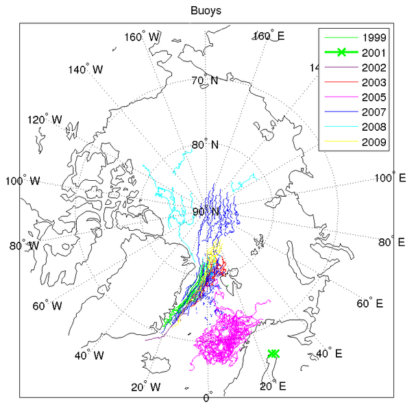
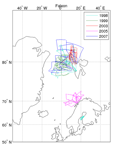
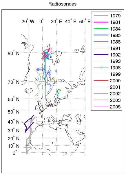
- North Atlantic and Arctic, irregular coverage (see figures above)
- Spatial resolution: irregular, along buoy, ship and airplane tracks, depends on measurement campaign and sensor
- Geographic longitude: -10°E to 40°E (rawinsonde); -20°E to 30°E (airplane); -180°E bis 180°E (buoy)
- Geographic latitude: -5°N to 85°N (rawinsonde); 60°N to 85°N (airplane); 60°N to 90°N (buoy)
- Dimension: irregular, 1- or 2-dimensional, depends on measurement campaign and sensor
- Altitude: Vertical profiles (rawinsonde); vertical sections (airplane), 0.0 m (buoy)
Format:
- ASCII and NetCDF
Data quality
All datasets contain usable data, as utilized by project participants. The data are checked for out of range values and data gaps. In some cases processing like interpolation or averaging was applied. Details are given in documentation provided with each dataset.
Some datasets additionally provide unprocessed raw data.
Contact
Gerd Müller
Meteorological Institute / University of Hamburg
E-Mail: gerd.mueller (at) uni-hamburg.de
Tel: +49 40 42838 5086Annika Jahnke-Bornemann
ICDC / CEN / University of Hamburg
E-Mail: annika.jahnke-bornemann"AT"uni-hamburg.de
References
Detailed documentation of each dataset is contained in the “Additional Info” document (pdf format) available on the CERA-DB. These documents also provide extensive references.
Data citation
Please cite the data as follows:
Examples how to cite the datasets are presented on the CERA website. For example:
Brümmer, B., G. Müller, C. Wetzel 2011; FRAMZY 2009 - Drift buoys experiment. World Data Center for Climate. CERA-DB "UNI_HH_MI_FRAMZY2009" http://cera-www.dkrz.de/WDCC/ui/Compact.jsp?acronym=UNI_HH_MI_FRAMZY2009
and with the following acknowledgments:
Thanks to ICDC, CEN, University of Hamburg for data support.
