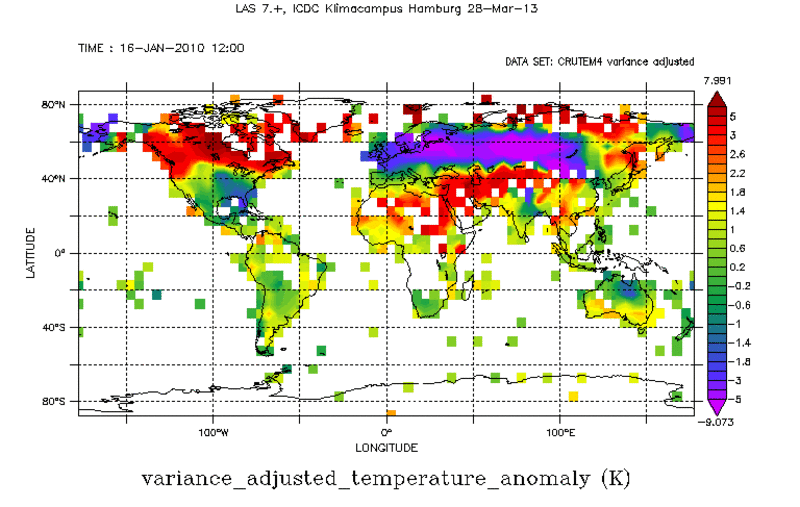
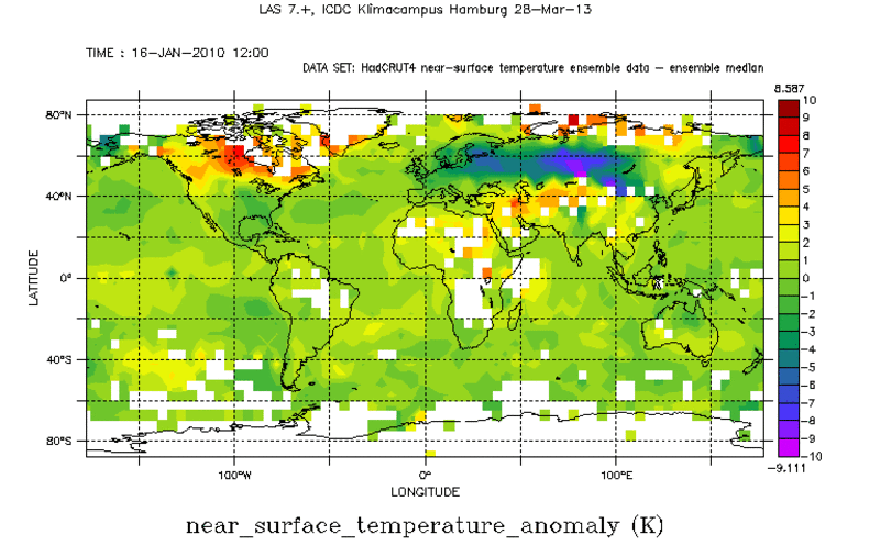
Surface Temperature Anomalies from CRUTEM and HadCRUT


Topics
- Access
- Description
- Parameters
- Coverage, spatial and temporal resolution
- Data quality
- Contact person
- References
- Data citation
Access
RESTRICTED:This link to the data set is only available for a restricted user group. The data set is only accessible in CEN/MPI net or accessible from external nets with a customer account. Please contact ICDC if you would like to access this data from outside the network.
- Access data via OPeNDAP: CRUTEM | HadCRUT
- Data access via file system:
- /data/icdc/atmosphere/crutem
- /data/icdc/atmosphere/hadcrut
Description
Long-term observations of near surface air temperature and sea surface temperature play a key role for climate system analysis.
CRUTEM5, HadCRUT5, and the 1961-1990 temperature climatology (Land: CRU, Jones et al. 1999, see references, Ocean: HadSST.3.1.0.0) which are offered via this website are gridded data sets of global historical land surface (and sea surface) temperature anomalies. HadCRUT5 and CRUTEM5 are from version 5.0.2.0. Data are available for each month since January 1850, on a 5 degree grid. The data sets are collaborative products of the Met Office Hadley Centre and the Climatic Research Unit at the University of East Anglia.
CRUTEM5 are limited to land stations; HadCRUT5 is a blend of the CRUTEM5 land-surface air temperature data set and the HadSST4 sea-surface temperature data set.
Common to all these data sets is that these display the anomaly of the respective observations relative to the period 1961-1990. First the anomaly of the station values is computed and then all anomalies are gridded into a 5° x 5° grid.
Last update of data set at ICDC: July 17, 2025
Parameters
| Name | Unit | Data Set |
|---|---|---|
| Surface air temperature anomaly [2m] | K | CRUTEM5 and HadCRUT5 |
| Sea surface temperature anomaly [0m] | K | HadCRUT5 |
| Number of observations per grid cell | - | CRUTEM5 |
| Sampling error | K | CRUTEM5 |
| Station error | K | CRUTEM5 |
| Combined measurement and sampling error | K | CRUTEM5 |
| Absolute 2 m air temperature (1961-1990 Climatology) | °C | CRU |
| Absolute SST [0 m] (1961-1990 Climatology) | °C | HadSST4 |
Coverage, spatial and temporal resolution
Period and temporal resolution:
- 1850-01 to 2025-02
- monthly
Coverage and spatial resolution:
- Global
- Spatial resolution: 5° x 5°, cartesian grid
- Geographic longitude: -177.5°E to 177.5°E
- Geographic latitude: -87.5°N to 87.5°N
- Dimension: 72 columns x 36 rows
- Altitude: 2 m (CRUTEM), 0 m & 2 m (HadCRUT)
Format:
- NetCDF
Data quality
The compilation of land air temperature records now includes more stations, and biases in sea surface temperature observations have been reduced. Improved methods of analysis and gridding extend the spatial coverage and reduce coverage biases and reduce uncertainty, especially in the period since 1960. New quality control proceedures are applied to screen for outliers in station data. The assessed uncertainties include those arising from thermometer accuracy, homogenisation, sampling of grid boxes with a finite number of measurements, large-scale biases such as urbanisation and estimation of regional averages with non-complete global measurement coverage.
For CRUTEM5 there are two versions. The "standard" CRUTEM5 uses the standard gridding method and is accompanied by an error model to provide estimates of the uncertainties in grid cell. Each grid-box value is the mean of all the station anomalies within that grid box. The "alternative" CRUTEM5alt uses a modified gridding method that removes the under-representation of high-latitude stations that occurs with the standard gridding method. Each station can contribute to multiple grid cells at the latitude of the station.There is no recommendation made as to which of the two should be used; we hence offer both.
For HadCRUT5 two data sets exist, the so-called "Analysis" and the so-called "non-infilled". The latter uses similar gridding methods as HadCRUT4, i.e. temperature anomaly values are estimated only in grid cells close to where we have measurements. HadCRUT5 Analysis estimates temperature anomalies using the spatial connectedness of temperature anomaly patterns. This extends the the geographical coverage by estimating temperature anomalies further from the available measurements. This improves the representation of less well observed regions in our estimates of global and hemispheric temperature change. We only offer the 200-member ensemble mean for "non-infilled" but we offer this mean and the 200 ensemble members for "Analysis".
For more information we refer to the references.
Contact
HadSST4:
John Kennedy
Metoffice
email: john.kennedy (at) metoffice.gov.uk
phone: +44-1392-885105CRUTEM5 & HadCRUT5:
Colin Morice
Metoffice
email: colin.morice (at) metoffice.gov.uk
phone: +44-1392-884566Stefan Kern
University of Hamburg
email: stefan.kern (at) uni-hamburg.de
References
- CRUTEM5: Osborne et al., 2021, J. Geophys. Res.-Atmos, 126, https://doi.org/10.1029/2019JD032352
- HadCRUT5: Morice et al., 2021, J. Geophys. Res.-Atmos, 126, https://doi.org/10.1029/2019JD032361
- HadSST4: Kennedy et al., 2019, J. Geophys. Res.-Atmos, 124, https://doi.org/10.1029/2018JD029867
- CRU: Jones, P. D., New, M., Parker, D. E., Martin, S., and Rigor, I. G. (1999), Surface air temperature and its changes over the past 150 years, Rev. Geophys., 37( 2), 173– 199, doi:10.1029/1999RG900002.
Websites
- HadCRUT5 Website, https://www.metoffice.gov.uk/hadobs/hadcrut5/data/current/download.html
- Met Office Hadley Centre observations datasets http://www.metoffice.gov.uk/hadobs/
- CRU Climatic Research Unit : Temperarure Data http://www.cru.uea.ac.uk/cru/data/temperature/
- CRUTEM5 Website at Metoffice, https://www.metoffice.gov.uk/hadobs/crutem5/
- HadSST Website at Metoffice, https://www.metoffice.gov.uk/hadobs/hadsst4/
Data citation
Please cite the data as follows:
- CRUTEM5: Osborne et al., 2021, J. Geophys. Res.-Atmos, 126, https://doi.org/10.1029/2019JD032352
- HadCRUT5: Morice et al., 2021, J. Geophys. Res.-Atmos, 126, https://doi.org/10.1029/2019JD032361
- HadSST4: Kennedy et al., 2019, J. Geophys. Res.-Atmos, 124, https://doi.org/10.1029/2018JD029867
- CRU: Jones et al., 1999, Rev. Geophys., 37(2).
HadCRUT.[5.0.2.0] data were obtained from http://www.metoffice.gov.uk/hadobs/hadcrut5 on [June 30, 2025] and are © British Crown Copyright, Met Office [year of first publication], provided under an Open Government License, http://www.nationalarchives.gov.uk/doc/open-government-licence/version/3/
CRUTEM.[5] data were obtained from http://www.metoffice.gov.uk/hadobs/crutem5 on [June 30 2025] and are © British Crown Copyright, Met Office [year of first publication], provided under an Open Government License, http://www.nationalarchives.gov.uk/doc/open-government-licence/version/3/
and with the following acknowledgments:
Thanks to ICDC, CEN, University of Hamburg for data support.
License
Please refer to the specified original sources for license information.
