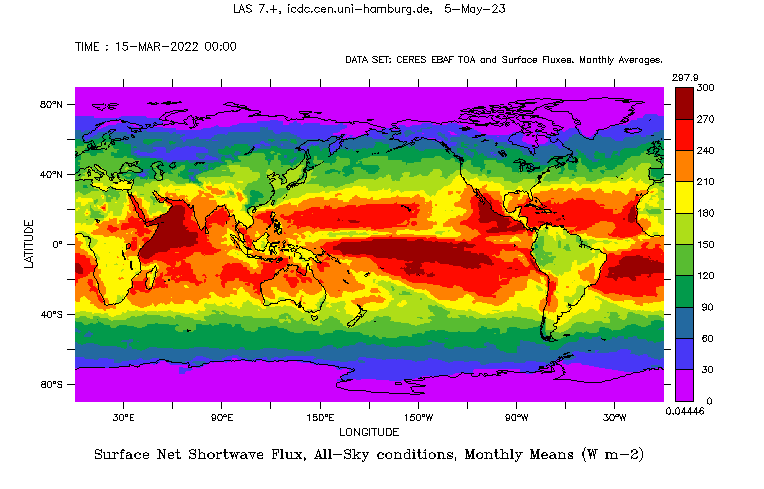
Radiation Fluxes from CERES

Topics
- Access
- Description
- Parameters
- Coverage, spatial and temporal resolution
- Data quality
- Contact person
- References
- Data citation
Access
RESTRICTED:This link to the data set is only available for a restricted user group. The data set is only accessible in CEN/MPI net or accessible from external nets with a customer account. Please contact ICDC if you would like to access this data from outside the network.
- Access CERES radiation data via OPeNDAP
- Data access via file system: /data/icdc/atmosphere/ceres_ebaf
Description
CERES stands for Clouds and Earth's Radiation Energy System. CERES products include both solar-reflected and Earth-emitted radiation from the top of the atmosphere (TOA) to the Earth's surface. Cloud properties are determined using simultaneous measurements by other EOS and NPP instruments such as the Moderate Resolution Imaging Spectroradiometer (MODIS) and the Visible and Infrared Sounder (VIRS).
CERES sensors are aboard TERRA and AQUA Earth Observation Satellite (EOS) satellites. These are 3-channel instruments with a shortwave: 0.3 - 5.0 µm, a longwave: 8 - 12 µm, and a so-called total: 0.3 to > 100 µm channel.
CERES TOA products are measured products, taking into account the solar radiation incident at the TOA. CERES surface products are a combination of CERES measured fluxes and atmospheric profiles (GEOS-5.4.1), NCEP SMOBA Ozone, MATCH aerosols and cloud cover properties derived from MODIS Collection 5 until March 2017.
Upwelling fluxes are defined positive, downwelling fluxes are defined negative. Products are available for all-sky and clear-sky conditions. Clear-sky conditions are defined as a 99% cloud-free CERES footprint (about 20 km resolution) using the CERES-MODIS clear-sky mask.
More information about the sensors and the data sets can be found on the CERES home page and in the literature stated in the references section.
This is Version Ed4.2 (Surface) and Ed4.2 (TOA) of the CERES-EBAF Products. This version has several improvements compared to version 2.8, most importantly the usage of advanced and more consistent input data (see references). For changes with respect to V4.0 and V4.1 see the CERES web page. Version Ed4.2 continues Ed4.1 in that sense that it takes into account the ageing process of TERRA and AQUA and their shift in orbits towards their terminating orbits for their expected decommissioning in 2026. In Ed4.2 data are based on TERRA and/or AQUA until including March 2022 and exclusively on NOAA20 after that.
Also included are data of the cloud radiative effect as well as the TOA incoming solar flux and, since version 4.0 also a few MODIS cloud parameters. Since the switch to version Ed4.2 we also offer zonal mean and global means values (monthly values and the mean seasonal cycle)
Last update of data set at ICDC: July 3, 2025
Parameters
| Name | Unit | Comment |
|---|---|---|
| TOA reflected shortwave radiation, all-sky | W/m^2 | |
| TOA outgoing longwave radiation, all-sky | W/m^2 | |
| TOA net radiation budget, all-sky | W/m^2 | |
| TOA reflected shortwave radiation, clearsky | W/m^2 | only for the cloud-free portion of the grid cell |
| TOA outgoing longwave radiation, clearsky | W/m^2 | see above |
| TOA net radiation budget, clearsky | W/m^2 | see above |
| TOA* reflected shortwave radiation, clearsky assumed | W/m^2 | for the entire grid cell |
| TOA* outgoing longwave radiation, clearsky assumed | W/m^2 | see above |
| TOA* net radiation budget, clearsky assumed | W/m^2 | see above |
| TOA* shortwave cloud radiative effect | W/m^2 | |
| TOA* longwave cloud radiative effect | W/m^2 | |
| TOA* net cloud radiative effect | W/m^2 | |
| TOA incoming solar flux | W/m^2 | |
| Surface shortwave downwelling radiation, all-sky | W/m^2 | |
| Surface shortwave upwelling radiation, all-sky | W/m^2 | |
| Surface longwave downwelling radiation, all-sky | W/m^2 | |
| Surface longwave upwelling radiation, all-sky | W/m^2 | |
| Surface net shortwave radiation, all-sky | W/m^2 | |
| Surface net longwave radiation, all-sky | W/m^2 | |
| Surface net total radiation. all-sky | W/m^2 | |
| Surface shortwave downwelling radiation, clearsky | W/m^2 | only for the cloud-free portion of the grid cell |
| Surface shortwave upwelling radiation, clearsky | W/m^2 | see above |
| Surface longwave downwelling radiation, clearsky | W/m^2 | see above |
| Surface longwave upwelling radiation, clearsky | W/m^2 | see above |
| Surface net shortwave radiation, clearsky | W/m^2 | see above |
| Surface net longwave radiation clearsky | W/m^2 | see above |
| Surface net total radiation, clearsky | W/m^2 | see above |
| Surface shortwave downwelling radiation, clearsky assumed | W/m^2 | for the entire grid cell |
| Surface shortwave upwelling radiation, clearsky assumed | W/m^2 | see above |
| Surface longwave downwelling radiation, clearsky assumed | W/m^2 | see above |
| Surface longwave upwelling radiation, clearsky assumed | W/m^2 | see above |
| Surface net shortwave radiation, clearsky assumed | W/m^2 | see above |
| Surface net longwave radiation clearsky assumed | W/m^2 | see above |
| Surface net total radiation, clearsky assumed | W/m^2 | see above |
| Surface shortwave cloud radiative effect | W/m^2 | |
| Surface longwave cloud radiative effect | W/m^2 | |
| Surface net cloud radiative effect | W/m^2 | |
| Cloud area fraction | % | |
| Cloud visible optical depth (daytime) | -- | |
| Cloud effective pressure | hPa | |
| Cloud effective temperature | K |
Coverage, spatial and temporal resolution
Period and temporal resolution:
- 2000-03 to 2024-12 (surface & TOA), to 2025-03 (TOA)
- Monthly

Coverage and spatial resolution:
- Global
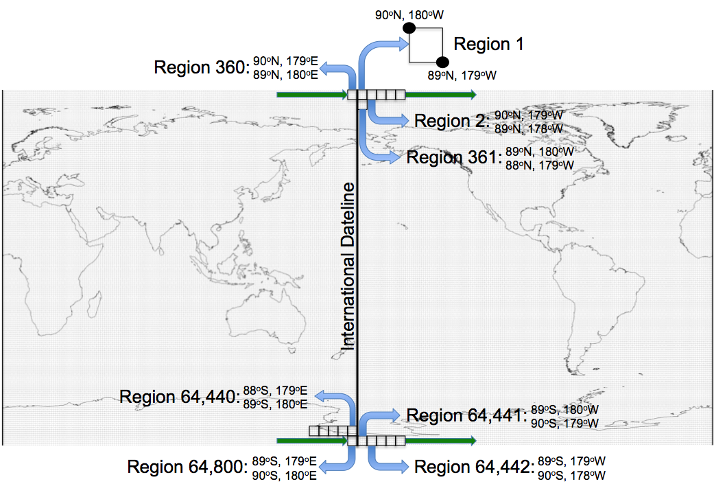
- Spatial resolution: 1° x 1°, cartesian grid (see figure)
- Geographic longitude: 180°W to 180°E
- Geographic latitude: 90°S to 90°N
- Dimension: 360 columns x 180 rows
- Altitude: following terrain for "surface", about 20 km above the Earth's reference ellipsoid for "TOA"
- In addition: Zonal means [monthly and mean seasonal cycle]; global means [monthly and mean seasonal cycle]
Format:
- NetCDF
Data quality
The offered data sets do not contain uncertainty estimates. A number of documents exist which summarize uncertainties and uncertainty sources as well as the results of the evaluation procedures, some of them are stated in the references.
Contact
NASA
CERES staff
Help Desk
email: ceres-help (at) lists.nasa.govSeiji Kato
NASA CERES-Staff
email: seiji.kato (at) nasa.govNorman Loeb
NASA CERES-Staff
email: norman.g.loeb (at) nasa.govStefan Kern
University of Hamburg
email: stefan.kern (at) uni-hamburg.de
References
- CERES Webpage: https://ceres.larc.nasa.gov/
- CERES Online Documentation, https://ceres.larc.nasa.gov/data/documentation/
- CERES EBAF-Surface Ed4.2 version 3 Data Quality Summary (March 2024) (pdf, not barrier free)
- CERES EBAF Ed4.2 Data Quality Summary (January 2023) (pdf, not barrier free)
- CERES EBAF Ed4.1 Data Quality Summary (September 2021) (pdf, not barrier free)
- CERES EBAF-Surface Ed4.1 Data Quality Summary (May 2021) (pdf, not barrier free)
- Loeb, N. G., et al., 2009, Toward Optimal Closure of the Earth's Top-of-Atmosphere Radiation Budget, Journal of Climate, 22(3), 748-766. doi: 10.1175/2008JCLI2637.1 , https://doi.org/10.1175/2008JCLI2637.1
- Kato, S., et al., 2013, Surface irradiances consistent with CERES-derived top-of-atmosphere shortwave and longwave irradiances. Journal of Climate, 26, 2719-2740, doi: 10.1175/JCLI-D-12-00436.1, https://doi.org/10.1175/JCLI-D-12-00436.1
- Loeb, N.G., et al., 2016, CERES Top-of-Atmosphere Earth radiation budget climate data record: Accounting for in-orbit changes in instrument calibration. Remote Sensing, 8, 182, doi:10.3390/rs8030182 (pdf, not barrier free)
- Riihela, A., et al., 2017, An intercomparison and validation of satellite-based surface radiative energy flux estimates over the Arctic. Journal of Geophysical Research - Atmospheres, 122, 4829-4848. (pdf, not barrier free)
- Loeb, N. G., et al., 2018, Clouds and the Earth's Radiant Energy System (CERES) Energy Balanced and Filled (EBAF) Top-of-Atmosphere (TOA) Edition-4.0 Data Product, Journal of Climate, 31(2), 895-918. (pdf, not barrier free)
- Kato, S., et al., 2018, Surface Irradiance of Edition 4.0 Clouds and the Earth's Radiant Energy System (CERES) Energy Balanced and Filled (EBAF) Data Product. Journal of Climate, 31(11), doi: 10.1175/JCLI-D-17-0523.1. (pdf, not barrier free)
- Jia, A., et al., 2018, Comprehensive assessment of global surface net radiation products and uncertainty analysis, Journal of Geophysical Research - Atmospheres, 123, 1970-1989, doi: 10.1002/2017JD027903. (pdf, not barrier free)
- Sun-Mack, S., et al., 2018, Calibration changes to Terra MODIS Collection-5 radiances for CERES Edition 4 cloud retrievals. Transactions on Geoscience and Remote Sensing, 56(10), doi: 10.1109/TGRS.2018.2829902.
Data citation
Please cite the data as follows:
- Original CERES EBAF_Ed4.2 SURFACE / TOA data were obtained from the NASA Langley Research Center CERES ordering tool at (http://ceres.larc.nasa.gov/), last access date: June 17, 2025, doi.org/10.5067/TERRA-AQUA/CERES/EBAF_L3B.004.2 and are provided by the Integrated Climate Data Center ICDC, CEN, University of Hamburg.
- For SURFACE parameters: Kato, S., N. G. Loeb, F. G. Rose, D. R. Doelling, D. A. Rutan, T. E. Caldwell, L. Yu, and R. A. Weller, 2013: Surface irradiances consistent with CERES-derived top-of-atmosphere shortwave and longwave irradiances. Journal of Climate, 26, 2719-2740, doi: 10.1175/JCLI-D-12-00436.1
- For TOA parameters: Loeb, N. G., B. A. Wielicki, D. R. Doelling, G. L. Smith, D. F. Keyes, S. Kato, N. Manalo-Smith, and T. Wong, 2009: Toward Optimal Closure of the Earths Top-of-Atmosphere Radiation Budget, Journal of Climate, 22(3), 748-766, doi.org/10.1175/2008JCLI2637.1
and with the following acknowledgments:
Thanks to ICDC, CEN, University of Hamburg for data support.
