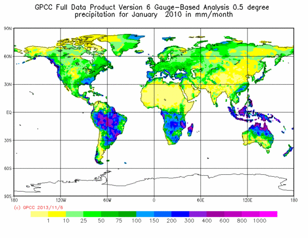
Global Precipitation over Land from GPCC full Data Reanalysis

Topics
- Access
- Description
- Parameters
- Coverage, spatial and temporal resolution
- Data quality
- Contact person
- References
- Data citation
Access
UNRESTRICTED:
RESTRICTED:This link to the data set is only available for a restricted user group. The data set is only accessible in CEN/MPI net or accessible from external nets with a customer account. Please contact ICDC if you would like to access this data from outside the network.
- View GPCC Reanalysis data at LAS
- Access GPCC Reanalysis data via OPeNDAP
- Data access via file system: /data/icdc/atmosphere/gpcc_full_data_reanalysis
Description
The Global Precipitation Climatology Centre (GPCC) is operated by the German Weather Service (DWD) under the auspices of the World Meteorologic Organization (WMO). It has the task of collecting global in-situ precipitation data to produce quantitative global precipitation and water balance analyses.
The "GPCC Full Data Reanalysis" contains sums of precipitation over land and is more than one hundred years long: It starts in 1891 and ends in 2016 (Version 2018). For this reanalysis quality controlled data from all globally available land stations (rain gauges) are used. The number of stations that were used to create the gridded data set has spatial and temporal variations, and is therefore included in the data set as a variable. The gridded final data set is optimized for best spatial coverage and use in water balance estimations and was used for trend analysis. This GPCC reanalysis has a higher accuracy in the precipitation data than the near real time products such as the GPCC Monitoring Product, that is available at ICDC as well. More detailed information on the methods applied for the preparation and interpolation of the original data can be taken from the cited literature, see references.
The "GPCC Full Data Reanalysis" is available in three spatial resolutions. ICDC has provided the highest resolution of 0.25 °.
Last update of data set at ICDC:
Parameters
| Name | Unit |
|---|---|
| Sum of precipitation | mm/Month |
| Number of gauges per grid | Number |
Coverage, spatial and temporal resolution
Period and temporal resolution:
- 01/1891 to 12/2016
- Monthly
Coverage and spatial resolution:
- Global, over land
- Spatial resolution: 0.25° x 0.25°, cartesian grid
- Geographic longitude: -180°E to 180°E
- Geographic latitude: -90°N to 90°N
- Dimension: 1440 columns x 720 rows
- Altitude: following terrain
Format:
- NetCDF
Data quality
The high quality of the data is assured by the DWD. It is the most accurate data set of the GPCC. Users of the gridded data sets should take into account the number of gauges per gridpoint. According to GPCC, this data set is suitable for regional climate monitoring, model validation, analysis of climate variability and water availability. The monthly precipitation data have been checked statistically and the data flagged as questionable passed through an additional visual quality-control. In addition to that the monthly precipitation data have been checked for spatial and temporal homogeneity. More detailed information is available in the stated references.
Contact
Herr Dr. Andreas Becker (Leiter des WZN)
Annika Jahnke-Bornemann
Weltzentrum für Niederschlagsklimatologie
c/o Deutscher Wetterdienst
Referat KU42
Postfach 10 04 65
63004 Offenbach am Main
Tel.: +49 (0)69 / 8062-2900
Fax: +49 (0)69 / 8062-3987
email: gpcc (at) dwd.de
ICDC / CEN / University of Hamburg
E-Mail: annika.jahnke-bornemann"AT"uni-hamburg.de
References
Websites:
- Weather and Climate - Deutscher Wetterdienst -- Klimadatenzentrum-WZN, http://wzn.dwd.de/
- GPCC Full Data Reanalysis Version 2018 Download, https://opendata.dwd.de/climate_environment/GPCC/html/fulldata-monthly_v2018_doi_download.html
Literature:
- "Global gridded precipitation over land: a description of the new GPCC First Guess Daily product" K. Schamm, M. Ziese, A. Becker, P. Finger, A. Meyer-Christoffer, U. Schneider, M. Schröder, and P. Stender in Earth System Science Data, DOI: 10.5194/essd-6-49-2014
- "Evaluating the hydrological cycle over land using the newly-corrected precipitation climatology from the Global Precipitation Climatology Centre (GPCC)" U. Schneider, P. Finger, A. Meyer-Christoffer, E. Rustemeier, M. Ziese, and A. Becker, 2017: Global Precipitation Climatology Centre, Deutscher Wetterdienst, Offenbach, Germany in Atmosphere, 8 (3), 52, DOI: 10.3390/atmos8030052
- Schneider, U., A. Becker, P. Finger, A. Meyer-Christoffer, M. Ziese, B. Rudolf (2013): "GPCC's new land surface precipitation climatology based on quality-controlled in situ data and its role in quantifying the global water cycle", Global Precipitation Climatology Centre, Deutscher Wetterdienst, Offenbach, Germany, in Theoretical and Applied Climatology, DOI: http://dx.doi.org/10.1007/s00704-013-0860-x
- Becker, A., P. Finger, A. Meyer-Christoffer, B. Rudolf, K. Schamm, U. Schneider, and M. Ziese (2013): "A description of the global land-surface precipitation data products of the Global Precipitation Climatology Centre with sample applications including centennial (trend) analysis from 1901–present", Global Precipitation Climatology Centre, Deutscher Wetterdienst, Offenbach, Germany, in Earth System Science Data, DOI: http://dx.doi.org/10.5194/essd-5-71-2013
- "The GPCC Drought Index - a new, combined and gridded global drought index" M. Ziese, U. Schneider, A. Meyer-Christoffer, K. Schamm, J. Vido, P. Finger, P. Bissoli, S.Pietsch, A. Becker in Earth System Science Data, DOI: 10.5194/essd-6-285-2014
Data citation
Users of the GPCC datasets are asked for feedback to DWD about usage.
Please cite the data as follows:
Schneider, Udo; Becker, Andreas; Finger, Peter; Meyer-Christoffer, Anja; Ziese, Markus (2018): GPCC Full Data Monthly Product Version 2018 at 0.25°: Monthly Land-Surface Precipitation from Rain-Gauges built on GTS-based and Historical Data. DOI: 10.5676/DWD_GPCC/FD_M_V2018_025 .
and with the following acknowledgments:
Thanks to ICDC, CEN, University of Hamburg for data support.
