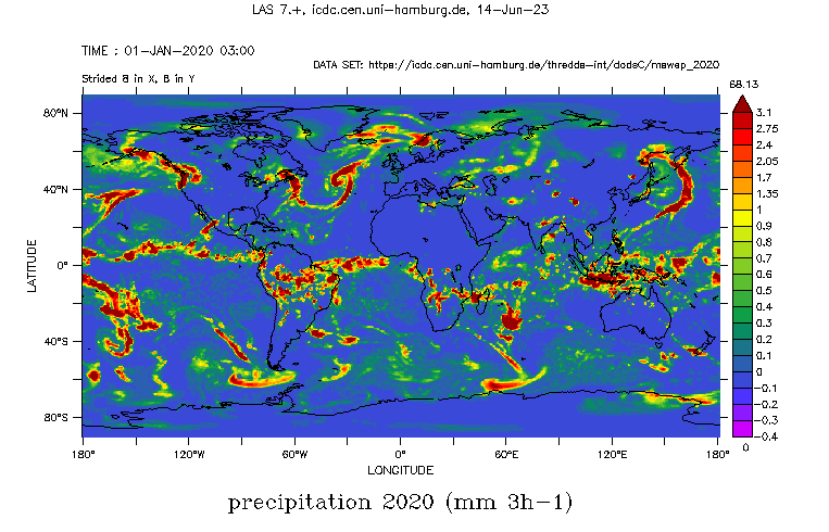
Precipitation amount from MSWEP

Topics
- Access
- Description
- Parameters
- Coverage, spatial and temporal resolution
- Data quality
- Contact person
- References
- Data citation and License
Access
RESTRICTED: This link to the data set is only available for a restricted user group. The data set is only accessible in CEN/MPI net or accessible from external nets with a customer account. Please contact ICDC if you would like to access this data from outside the network.
- Access MSWEP data via OPeNDAP
- Data access via file system: /data/icdc/atmosphere/mswep_precipitation
Description
MSWEP stands for Multi-Source Weighted-Ensemble Precipitation and is a global precipitation product with a 3‑hourly 0.1° resolution available from 1979 to ~3 hours from real-time. The product is unique in that it merges gauge, satellite, and reanalysis data to obtain the highest quality precipitation estimates at every location.
MSWEP incorporates daily gauge observations and accounts for gauge reporting times to reduce temporal mismatches between satellite-reanalysis estimates and gauge observations. MSWEP is compatible with GloH2O’s operational Multi-Source Weather (MSWX); MSWX forecasts can thus be used to extend MSWEP into the future. MSWEP tends to exhibit better performance than other precipitation products in both densely gauged and ungauged regions (see the Performance section here, Beck et al., 2017, and Beck et al., 2019 - see references).
We offer data of years 1979-2020 of version v2.8 of the data set. Data are provided by the original data set provider with ~3 hour latency (see https://www.gloh2o.org/mswep)
The data set was made available at ICDC: June 15, 2023
Parameters
| Name | Unit |
|---|---|
| Precipitation amount | mm/3h |
Coverage, spatial and temporal resolution
Period and temporal resolution:
- 1979-01-01 to 2020-12-31
- 3-hourly
Coverage and spatial resolution:
- Global
- Spatial resolution: 0.1 ° x 0.1 °, Cartesian grid
- Longitude: -179.95 ° E to 179.95 ° E
- Geographic latitude: -89.95 ° N to 89.95 ° N
- Dimension: 3600 columns x 1800 rows
- Height: Terrain-Following
Format:
- NetCDF
Data quality
The data set offered here does not contain any estimates of the uncertainty.
Contact
Contact section of the gloh2o web page:
https://www.gloh2o.org/contact/Stefan Kern
ICDC / CEN / Universität Hamburg
email: stefan.kern (at) uni-hamburg.de
References
Literature:
- Beck, H. E., Vergopolan, N., Pan, M., Levizzani, V., van Dijk, A. I. J. M., Weedon, G. P., Brocca, L., Pappenberger, F., Huffman, G. J., and Wood, E. F.: Global-scale evaluation of 22 precipitation datasets using gauge observations and hydrological modeling, Hydrol. Earth Syst. Sci., 21, 6201–6217, https://doi.org/10.5194/hess-21-6201-2017, 2017.
- Beck, H. E., Pan, M., Roy, T., Weedon, G. P., Pappenberger, F., van Dijk, A. I. J. M., Huffman, G. J., Adler, R. F., and Wood, E. F.: Daily evaluation of 26 precipitation datasets using Stage-IV gauge-radar data for the CONUS, Hydrol. Earth Syst. Sci., 23, 207–224, https://doi.org/10.5194/hess-23-207-2019, 2019.
Websites
Data citation, License, and Acknowledgments
Please cite the two papers given above and refer to https://www.gloh2o.org/mswep/ [last access: June 14 2023]; last data download: May 5 2023.
and use the following acknowledgment:
Thanks to the Integrated Climate Data Center (ICDC https://www.cen.uni-hamburg.de/icdc/), CEN, University of Hamburg, Hamburg, Germany for data support.
License
MSWEP is released under the Creative Commons Attribution-NonCommercial 4.0 International (CC BY-NC 4.0) license.
