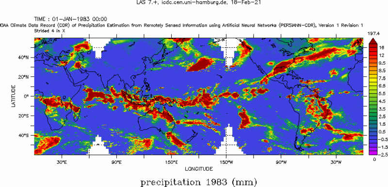
Precipitation amount from PERSIANN

Topics
- Access
- Description
- Parameters
- Coverage, spatial and temporal resolution
- Data quality
- Contact person
- References
- Data citation and License
Access
RESTRICTED: This link to the data set is only available for a restricted user group. The data set is only accessible in CEN/MPI net or accessible from external nets with a customer account. Please contact ICDC if you would like to access this data from outside the network.
- View PERSIANN data at LAS
- Access PERSIANN data via OPeNDAP
- Data access via file system: /data/icdc/atmosphere/persiann
Description
PERSIANN stands for "Precipitation Estimation from Remote Sensed Information Using Artificial Neural Networks"; it is a climate data set from NOAA. We offer the PERSIANN climate data set of the amount of precipitation with daily resolution of version v01r01 (predecessor: v01r00).
The "Precipitation Estimation from Remotely Sensed Information using Artificial Neural Networks - Climate Data Record (PERSIANN-CDR)" contains the daily amount of precipitation between 60 ° S and 60 ° N with a grid cell resolution of 0.25 degrees for the years 1983 to today. The main data basis is the so-called "GridSat-B1 infrared satellite data" [This is essentially data from the sensors MVIRI, SEVIRI, S-VISSR, GOES-Imager, VISSR + JAMI, VIRS + TMI on the platforms MeteoSat, MeteoSat-2G, FY2, GOES, HIMAWARI, GMS, MTSAT and TRMM] from which the amount of precipitation is derived using the PERSIANN algorithm.
The Artificial Neural Network used is trained with the National Centers for Environmental Prediction (NCEP) stage IV precipitation product with hourly resolution. Finally, the PERSIANN-CDR is scaled with the Global Precipitation Climatology Project (GPCP) product version 2.2 (GPCPv2.2) so that a PERSIANN-CDR product that is blurred to the same spatial (2.5 degrees) and temporal (monthly mean) resolution is optimal for the GPCP Product fits.
Detailed information can be found on the CHRS Mission Statement website, the corresponding NCAR Climat Data Guide website and the other references. We offer version v01 revision r01 of the data set.
Last update of data set at ICDC: March 06, 2025
Parameters
| Name | Unit |
|---|---|
| Precipitation amount | mm/day |
Coverage, spatial and temporal resolution
Period and temporal resolution:
- 1983-01-01 to 2024-03-31
- daily
Coverage and spatial resolution:
- Globally between -60.0 ° N and 60.0 ° N
- Spatial resolution: 0.25 ° x 0.25 °, Cartesian grid
- Longitude: 0.125 ° E to 359.875 ° E
- Geographic latitude: -59.875 ° N to 59.875 ° N
- Dimension: 1440 columns x 480 rows
- Height: Terrain-Following
Format:
- NetCDF
Data quality
The data set offered here does not contain any estimates of the uncertainty.
Contact
Hamed Ashouri
Center for Hydrometeorology and Remote Sensing
University of Irvine, CA, U.S.
email: h.ashouri (at) uci.eduDan Braithwaite
Center for Hydrometeorology and Remote Sensing
University of Irvine, CA, U.S.
email: dbraithw (at) uci.eduStefan Kern
Universität Hamburg
email: stefan.kern (at) uni-hamburg.de
References
Literature:
- Ashouri, H., et al., PERSIANN-CDR: Daily precipitation climate data record from multisatellite observations for hydrological and climate studies. Bull. Amer. Meteor. Soc., 96, 69–83, 2015, https://doi.org/10.1175/BAMS-D-13-00068.1 .
- Miao, C., et al., Evaluation of the PERSIANN-CDR Daily Rainfall Estimates in Capturing the Behavior of Extreme Precipitation Events over China, Journal of Hydrometeorology, 16(3), 1387-1396, 2015, https://doi.org/10.1175/JHM-D-14-0174.1 .
- Ashouri, H., et al., Assessing the Efficacy of High-Resolution Satellite-Based PERSIANN-CDR Precipitation Product in Simulating Streamflow, Journal of Hydrometeorology, 17(7), 2061-2076, 2016, https://doi.org/10.1175/JHM-D-15-0192.1 .
- Gehne, M., et al., Comparison of Global Precipitation Estimates across a Range of Temporal and Spatial Scales, Journal of Climate, 29(21), 7773-7795, 2016, https://doi.org/10.1175/JCLI-D-15-0618.1 .
- Hsu, K.-L., et al., Precipitation Estimation from Remotely Sensed Information Using Artificial Neural Networks, Journal of Applied Meteorology and Climatology, 36(9), 1176-1190, 1997, https://doi.org/10.1175/1520-0450(1997)036<1176:PEFRSI>2.0.CO;2 .
Websites:
- CHRS Mission Statement, https://chrs.web.uci.edu/
- PERSIANN-CDR: Precipitation Estimation from Remotely Sensed Information using Artificial Neural Networks - Climate Data Record | NCAR - Climate Data Guide, https://climatedataguide.ucar.edu/climate-data/persiann-cdr-precipitation-estimation-remotely-sensed-information-using-artificial
Data citation, License, and Acknowledgments
Please cite the data as follows:
Sorooshian, S., K. Hsu, D. Braithwaite, H. Ashouri, and NOAA CDR Program (2014): NOAA Climate Data Record (CDR) of Precipitation Estimation from Remotely Sensed Information using Artificial Neural Networks (PERSIANN-CDR), Version 1 Revision 1. [indicate subset used]. NOAA National Centers for Environmental Information. https://doi.org/10.7289/V51V5BWQ [last access: February 25, 2025], obtained with transposed latitude-longitude coordinates from https://www.cen.uni-hamburg.de/icdc, University of Hamburg.
and with the following acknowledgments:
Thanks to ICDC, CEN, University of Hamburg for data support.
License
Please see original data websites for license informations.
