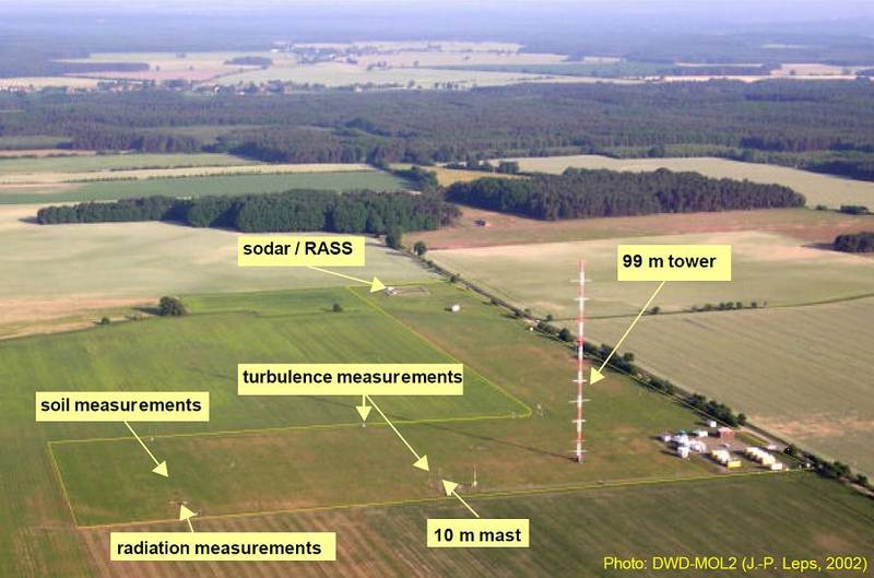
Atmospheric Boundary Layer Measurement Tower in Lindenberg

Topics
- Access
- Description
- Parameters
- Coverage, spatial and temporal resolution
- Data quality
- Contact person
- References
- Data citation
Access
RESTRICTED:This link to the data set is only available for a restricted user group. The data set is only accessible in CEN/MPI net or accessible from external nets with a customer account. Please contact ICDC if you would like to access this data from outside the network.
- Data access via file system: /data/icdc/atmosphere/weathermast_lindenberg
Description
The boundary layer field site at Lindenberg-Falkenberg is part of the meteorological measurement program of the German Weather Service (DWD). Lindenberg is well known for its long-term time series of vertical temperature, humidity and wind soundings carried out at the Richard-Aßmann Observatory. The boundary layer field site is located about 65 km southeast of Berlin in a rural landscape comprising a mixed coverage of meadows, forest, croplands and lakes within the neighborhood (< 10 km) of the site. Several measurement systems are operational at the site, namely a small (10m) and a tall (99m) measurement tower, and facilities for meteorological standard measurements, measurements of vertical soil moisture and temperature profiles, radiation, and turbulent fluxes (see the picture above). Measurements at the boundary layer field site started in 1998.
The tall tower is equipped with sensors to measure temperature, humidity, and wind speed and direction at heights of 10m, 20m, 40m, 60m, 80m, and 98m. A comprehensive list of the sensors at the tall towers and the other measurement facilities is given in the short documentation "CEOP Parameters Measured and Instrumentation" (see references).
The data offered here have been quality assessed for GEWEX / CEOP and comprise measurements from the tall tower levels at 40m and 98m, from the small tower levels at 2m and 10m, and from the standard meteorological parameter, the radiation, the soil profile and flux measurement facilities. More details are given in the Site and Data Report for the Lindenberg Reference Site in CEOP (see references).
Last update of data set at ICDC:
Parameters
| Name | Unit |
|---|---|
| air temperature [2m, 40m, 98m | °C |
| dew point (calculated) [2m, 40m, 98m] | °C |
| relative humidity [2m, 40m, 98m] | % |
| specific humidity [2m, 40m, 98m] | g/kg |
| wind speed [10m, 40m, 98m] | m/s |
| wind direction [10m, 40m, 98m] | ° |
| x-, y-component of wind vector [10m, 40m, 98m] | m/s |
| incoming & outgoing short-wave radiation) [2m] | W/m² |
| incoming & outgoing long-wave radiation [2m] | W/m² |
| net radiation (calculated) [2m] | W/m² |
| surface temperature | °C |
| precipitation amount (last 30 minutes) [1m] | mm |
| snow depth | cm |
| air pressure [1m, 40m, 98m] | hPa |
| incoming & outgoing photosynthetically active radiation (PAR) [2m] | µmol/m²s |
| friction velocity | m/s |
| sensible heat flux | W/m² |
| latent heat flux | W/m² |
| CO2 flux | µmol/m²s |
| soil heat flux | W/m² |
| soil temperature [5cm, 10cm, 15cm, 20cm, 30cm, 45cm, 50cm, 60cm, 90cm, 120cm, 150cm depth] | °C |
| soil moisture [8cm, 15cm, 30cm, 45cm, 60cm, 90cm depth] | Volume % |
Coverage, spatial and temporal resolution
Period and temporal resolution:
- 30-minute averages
- 2003-2010
Coverage and spatial resolution:
- Local, Lindenberg, Germany
- Spatial resolution: none, vertical profile
- Geographic latitude: 52.17°N
- Geographic longitude: 14.12°E
- Dimension: 1 column x 1 row x number of measurements vertically
- Altitude (Measurement site itself is 73 m a.s.l.): 2 m, 10 m, 40 m, 98 m
Format:
- ASCII, see documentation about formats details in the references
Data quality
Equations and assumptions required to calculate the derived quantities are given in "CEOP Derived Parameter Equations" (see references).
The data set does not contain uncertainty estimates. However, since the data set has been used within GEWEX/CEOP a number of quality checks have been carried out. The result of these checks is given as a number of quality flags:
| C |
Reported value exceeds the output format field size OR was negative (precipitation) |
| M | Parameter value missing OR derived parameter can not be computed |
| B | Bad |
| I | Interpolated / Estimated / Gap filled |
| D | Questionable / Dubious |
| G | Good |
| U | Unchecked |
Details about measurement accuracy of the used sensors can be found in the "DWD CEOP Report" page 29, which contains links to the manufacturer's web pages as well. Please contact Udo Rummel for more details.
Contact
Udo Rummel
Meteorological Observatory Lindenberg - Richard-Aßmann-Observatory, DWD, Tauche - Lindenberg
email: udo.rummel (at) dwd.de
phone: +49-69-80625786Stefan Kern
ICDC / CEN / University of Hamburg
E-Mail: stefan.kern"AT"uni-hamburg.de
References
Websites:
- German Weather Service (DWD)
- Meteorologisches Observatorium Lindenberg - Richard Aßmann-Observatorium
- Boundary Layer Field Site (GM) Falkenberg
- GEWEX
- CEOP Coordinated Energy and Water Cycle Observation Project in DKRZ's CERA Database
Documents:
- CEOP Parameters Measured and Instrumentation (pdf, not barrier free)
- Site and Data Report for the Lindenberg Reference Site in CEOP – Phase I (pdf, not barrier free)
- CEOP Meteorological Tower Dataset (pdf, not barrier free)
- CEOP Flux Dataset (pdf, not barrier free)
- CEOP Surface Meteorological and Radiation Dataset (pdf, not barrier free)
- CEOP Soil Temperature and Moisture Dataset (pdf, not barrier free)
- CEOP Derived Parameter Equations (pdf, not barrier free)
- DWD CEOP Report, page 29 (pdf, not barrier free)
Data citation
Please cite the data as follows:
.
and with the following acknowledgments:
Thanks to ICDC, CEN, University of Hamburg for data support.
