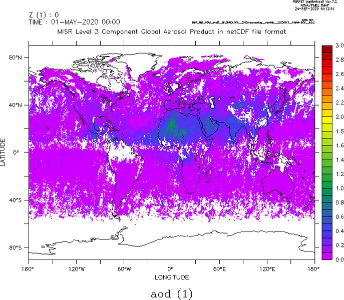
Aerosol Parameter from MISR

Topics
- Access
- Description
- Parameters
- Coverage, spatial and temporal resolution
- Data quality
- Contact person
- References
- Data citation
Access
RESTRICTED: This link to the data set is only available for a restricted user group. The data set is only accessible in CEN/MPI net or accessible from external nets with a customer account. Please contact ICDC if you would like to access this data from outside the network.
- MISR Aerosol via OPeNDAP
- MISR Aerosol via Filesystem: /data/icdc/atmosphere/misr_aerosol
Description
MISR is the acronym for Multi-angle Imaging Spectroradiometer. This sensor, equipped with four spectral bands in the visible / near-infrared wavelength range: 0.446, 0.557, 0.672, and 0.866 µm, operates from aboard the EOS-TERRA satellite since 2000. MISR acquires reflectances using nine cameras; one is looking nadir, while of the remaining eight cameras, four are looking into and four against the flight direction of the satellite at fixed view angles with respect to the Earth surface: 26.1, 45.6, 60.0, and 70.5 degrees. By means of its spectral resolution and permanently observing the atmosphere at the given different view angles, a large number of different aerosol and cloud parameters can be retrieved.
A list of the aerosol parameters which ICDC offers is this parameter list (txt-Format).
More information about the data sets can be found on the web pages of the Langley Atmospheric Science Data Center, here: https://asdc.larc.nasa.gov/project/MISR , and in the references.
ICDC offers the monthly globally gridded product at 0.5 degree grid resolution; this gridded product is based on the 2017 re-processing (version v23) and is based on the level-2 product with 4.4 km resolution obtained with the same re-processing.
Last update of this data set at ICDC: May 19, 2022.
Parameters
| Datentyp | Kommentar |
|---|---|
| Aerosol optical depth (AOD) | for different AOD levels |
| AOD - small mode | as above for small particles |
| AOD - medium mode | as 1st above for medium-size particles |
| AOD - large mode | as 1st above for large particles |
| AOD - non spherical | as 1st above for non-spherical particles |
| AOD - per band | as 1st above separately for the four wavelength bands |
| Angström exponent | as 1st above, using 550 nm and 860 nm |
| Absorbing optical depth (OD) | as 1st above |
| Absorbing OD per band | as above separately for the four wavelength bands |
| Retrievalkoeffizienten |
Coverage, spatial and temporal resolution
Period and temporal resolution:
- 2000-03-01 bis 2021-11-30
- Monthly
Coverage and spatial resolution:
- Global
- Spatial resolution: 0.5° x 0.5°, cartesian grid
- Geographic longitude: -179.75°E bis 179.75°E
- Geographic latitude: -89.75°N bis 89.75°N
- Dimension: 720 Spalten x 360 Zeilen
- Altitude: following terrain
Format:
- NetCDF
Data quality
Most of the MISR data offered here contain as a measure of uncertainty on the standard deviation of all level-2 grid cells used for the computation of the level-3 product. In addition, there are data layers for all parameters providing the count of valid level-2 product values used in the level-3 product in the respective grid cell.
We refer to the documents listed in the references for further information regarding evaluation activities of - mostly - the level-2 products; the qualtiy of these determines the level-3 product quality..
Contact
Michael J. Garay
MISR - Principal Investigator
NASA / JPL
email: michael.j.garay (at) jpl.nasa.govNASA Langley ASDC User Services
email: support-asdc (at) earthdata.nasa.govStefan Kern
ICDC / CEN / Universität Hamburg
email: stefan.kern (at) uni-hamburg.de
References
- MISR overview page for ATBDs: https://eospso.gsfc.nasa.gov/atbd-category/45
- MISR Level-2 aerosol retrieval ATBD (pdf, nicht barrierefrei)
- Diner, D. J., et al., Multi-Angle Imaging Spectroradiometer (MISR) - Instrument Description and Experiment Overview, IEEE Trans. Geosci. Rem. Sens., 36(4), 1072-1087, 1998. (pdf, nicht barrierefrei)
- Garay, M. J., et al., Development and assessment if a higher-spatial-resolution (4.4km) MISR aerosol optical depth product using AERONET-DRAGON data. Atmos. Chem. Phys., 17, 5095-5106, 2017, https://doi.org/10.5194/acp-17-5095-2017.
- Witek, M. L., et al., Oceanic aerosol loading derived from MISR's 4.4 km (V23) aerosol product. J. Geophys. Res.-Atmospheres, 124, 2019, https://doi.org/10.1029/2019JD031065.
- Garay, M. J., et al., Introducing the 4.4km spatial resolution Multi-Angle Imaging SpectroRadiometer (MISR) aerosol product. Atmos. Meas. Tech., 13, 593-628, 2020, https://doi.org/10.5194/amt-13-593-2020.
Data citation
Please cite the data as follows:
Garay, M. J., et al., (2017) MISR level 3, version 4 (reprocessing v23, 2017) monthly globally gridded aerorol parameters MIL3MAEN_L3.004 (https://doi.org/10.5067/Terra/MISR/MIL3MAEN_L3.004 ) were obtained from the NASA Langley Research Center Atmospheric Science Data Center [last access date: May 12, 2022] and equipped with a continuous time axis and redistributed in netCDF file format by ICDC, CEN, University of Hamburg.
