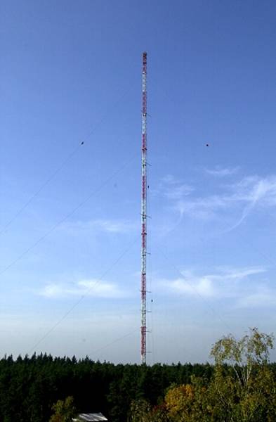
Atmospheric Boundary Layer Measurement Tower in Karlsruhe

Topics
- Access
- Description
- Parameters
- Coverage, spatial and temporal resolution
- Data quality
- Contact person
- References
- Data citation
Access
RESTRICTED:This link to the data set is only available for a restricted user group. The data set is only accessible in CEN/MPI net or accessible from external nets with a customer account. Please contact ICDC if you would like to access this data from outside the network.
- Data access via file system: /data/icdc/atmosphere/weathermast_karlsruhe
Description
The Karlsruhe Institute of Technology (KIT), Institute of Meteorology and Climate Research is operating a 200m tall weather tower since 1972 (see photography above). Additionally, standard meteorological parameters and near-surface radiative fluxes are measured.
At the tower measurements are carried out at altitudes of 2m, (10m), 20m, 30m, 40m, 50m, 60m, 80m, 100m, 130m, 160m, and 200m allowing atmospheric boundary layer studies. Measured parameters are wind speed and direction, air temperature and humidity; not all parameters are measured in all given altitudes, only for the altitudes 2m, 30m, 100m and 200m all parameters are available. Wind measurements at a height of 10m are not available because the measuring mast is in a wooded area.
Most of the sensors sample data every minute. We do not offer these original data. Available via ICDC are daily mean values. If you require data at finer temporal resolution please contact Martin Kohler. On the KIT weather mast homepage you can learn more about the Karlsruhe weather tower and take a glimpse at the current measured values.
Last update of data set at ICDC:
Parameters
| Name | Unit | since year |
|---|---|---|
| air temperature [2m, 10m, 30m, 60m, 100m, 130m, 160m 200m] | °C | 1973 |
| relative humidity [2m, 10m, 30m, 100m, 200m] | % | 1973 |
| wind speed [2m, 20m, 30m, 40m, 50m, 60m, 80m, 100m, 130m, 160m, 200m] | m/s | 1973 |
| cumulative incident shortwave radiation [10m] | W/m² | 1973 |
| precipitation amount | mm | 1973 |
Coverage, spatial and temporal resolution
Period and temporal resolution:
- 01-01-1973 until 05-31-1973
- daily (hourly on request)
Coverage and spatial resolution:
- Local, Karlsruhe, Germany
- Geographic latitude: 49° 5' 33'' N
- Geographic longitude: 8° 25' 33'' O
- Spatial resolution: none, vertical profile
- Altitude (location itself is 110.4 m a.s.l.) 2m, 10m, 20m, 30m, 40m, 50m, 60m, 80m, 100m, 130m, 160m, 200m
Format:
- ASCII
Data quality
The data set does not contain uncertainty estimates.
The majority of the data are direct measurements anyways so that the accuracy of the sensors is more important in this context. Still a quality control is and has been carried out with the data set.
Note that for the daily averages offered from this web portal about 50% of the measurements of one day needed to be available and of sufficient quality. Otherwise no daily average was computed.
A documentation about the different sensors and sensor types used is in preparation and foreseen to be available in 2014.
Note: In the precipitation data 0.0 mm means both: no precipitation occurred or precipitation occurred but its amount was below what can be measured.
Please contact Martin Kohler for more details..
Contact
Martin Kohler
Karlsruher Institut für Technologie (KIT), Institut für Meteorologie und Klimaforschung
email: martin.kohler (at) kit.edu
phone: +49-721-608-23995Stefan Kern
ICDC / CEN / University of Hamburg
E-Mail: stefan.kern@uni-hamburg.de<br />(stefan.kern"AT"uni-hamburg.de)
References
Websites:
- Karlsruhe Institute of Technology (KIT), http://www.kit.edu/
- Institute of Meteorology and Climate Research, http://www.imk-tro.kit.edu/121.php
- Homepage Karlsruhe Weather mast, http://www.imk-tro.kit.edu/7779.php
- Kalthoff, N., and B. Vogel, 1992: Counter-Current and Channelling Effect Under Stable Stratification in the Area of Karlsruhe. Theor. Appl. Climatol., 45(2), 113-126.
- Wenzel, A., N. Kalthoff, and V. Horlacher, 1997: On the Profiles of Wind Velocity in the Roughness Sublayer above a Coniferous Forest. Bound.-Lay. Meteorol., 84(2), 219-230.
- Barthlott, C., N. Kaltoff, and F. Fiedler, 2003: Influence of high-frequency radiation on turbulence measurements on a 200 m tower. Meteorologische Zeitschrift, 12(2), 67-71, DOI: 10.1127/0941-2948/2003/0012-0067.
Data citation
Please cite the data as follows:
In case you use this data for a presentation, a study, a thesis or a scientific article please contact Martin Kohler for correct citation.
Data for xyz (the used parameters) for ttt (time period) were obtaind from ICDC, CEN, University of Hamburg.
and with the following acknowledgments:
Thanks to ICDC, CEN, University of Hamburg for data support.
