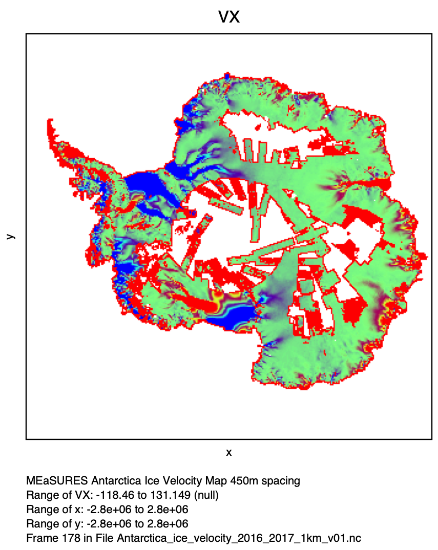
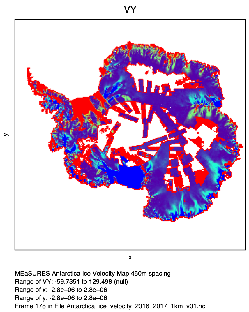
Ice velocity of Antarctic Ice Sheet


Topics
- Access
- Description
- Parameters
- Coverage, spatial and temporal resolution
- Data quality
- Contact person
- References
- Data citation
Access
UNRESTRICTED:
RESTRICTED: This link to the data set is only available for a restricted user group. The data set is only accessible in CEN/MPI net or accessible from external nets with a customer account. Please contact ICDC if you would like to access this data from outside the network.
- Data access via file system: /data/icdc/ice_and_snow/antarctic_glac/
Description
The ice velocity of the Antarctic ice sheet's outlet glaciers and the areas feeding these glaciers are an important parameter for the quantification of the mass balance of the ice sheet and ice shelves, and for its future development. The break-up or disintegration of such an entire ice shelf like the Larsen Ice Shelf, or the Wilkens Ice Shelf can substantially impact the ice velocity of the glaciers that (used to) feed these ice shelves. A correct quantification of the ice velocity is therefore important also to gain a better knowledge about the future stability of the glacier itself and of the ice sheet areas upstream feeding this glacier.
Ice velocities are derived using Synthetic Aperture Radar (SAR) data. One way is to track speckle in both along (azimuth) and across (range) track directions and by calculation of the two dimensional offsets in amplitude imagery derive the ice velocity. The second approach is to combine the interferometric phases of two independent tracks to retrieve the surface flow vector.
Data from a number of different SAR sensors are used for this dataset (depending on their availability): RADARSAT-1 und -2 SAR, Envisat ASAR, ALOS Palsar und ERS1/2 SAR, TerraSAR-X, TanDEM-X and Sentinel-1 are used; in order to increase coverage optical imagery from Landsat-8 is used in addition. Coverage in version 02 increased to 99.6%. Details can be taken from the references down below.
We note that recently there has been a new publication & data set about the Antarctic ice velocity with an order of magnitude improvement in precision of speed and direction (see Mouginot et al. 2019 in the references).
Last update of data set at ICDC: February 16 2023.
Parameters
| Name | Unit |
|---|---|
| velocity x-direction | m/year |
| velocity y-direction | m/year |
| velocity component x-direction uncertainty | m/year |
| velocity component y-direction uncertainty | m/year |
| velocity component x-direction standard deviation | m/year |
| velocity component y-direction standard deviation | m/year |
| count of scenes used for each grid cell | - |
Coverage, spatial and temporal resolution
Period and temporal resolution:
- 2000/01 and 2005/06 to 2019/20
- annually
Coverage and spatial resolution:
- Antarctic
- Spatial resolution: 1 km x 1 km, polar-stereographic grid, centred at 71°S
- Geographic longitude: 0°E to 360°E
- Geographic latitude: south of 60°S
- Altitude: following terrain
Format:
- NetCDF
Data quality
The data set contains an uncertainty estimation for the velocity components in addition to the number of scenes that were used for the respective pixel.
The precision of ice flow mapping varies with the sensor, the geographic location, the technique of interferometric analysis, the time period of analysis, the repeat cycle, and the amount of data stacking. The total error is the square root of the sum of the independent errors squared and ranges between about 1 m/year for ERS1/2 and around 10 m/year for ALOS PALSAR and one order of magnitude better in the new phase-based data set. These estimates, however, should be used more as an indication of relative quality rather than absolute error.
We recommend the documentation and the publications listed in the references down below for further reading.
Contact
Eric Rignot
University of California, Irvine
Department of Earth System Science
Croul Hall, Irvine, California 92697, USA
email: eric.rignot (at) jpl.nasa.govNSIDC User Services
National Snow and Ice Data Center
CIRES, 449 UCB
University of Colorado
Boulder, CO 80309-0449, USA
email: nsidc (at) nsidc.orgStefan Kern
ICDC / CEN / University of Hamburg
email: stefan.kern (at) uni-hamburg.de
References
Literature:
- Documentation of the data sets at NSIDC: version 01 annual
- Rignot, E., J. Mouginot, and B. Scheuchl. 2011. Ice Flow of the Antarctic Ice Sheet, Science. 333. 1427-1430. http://dx.doi.org/10.1126/science.1208336
- Mouginot, J., B. Scheuchl, and E. Rignot. 2012. Mapping of Ice Motion in Antarctica Using Synthetic-Aperture Radar Data, Remote Sensing. 4. 2753-2767. http://dx.doi.org/10.3390/rs4092753
- Mouginot, J., E. Rignot, B. Scheuchl, and R. Millan, 2017. Comprehensive Annual Ice Sheet Velocity Mapping Using Landsat-8, Sentinel-1, and RADARSAT-2 Data. Remote Sensing 9(4): Art. #364. doi: http://dx.doi.org/10.3390/rs9040364
- Mouginot, J., E. Rignot, and B. Scheuchl, 2019, Continent-wide, interferometric SAR phase, mapping of Antarctic ice velocity, Geophys. Res. Lett., 46, 9710-9718, https://doi.org/10.1029/2019GL083826
Data citation
Please cite the data as follows:
Mouginot, J., B. Scheuchl, and E. Rignot. 2017. MEaSUREs Annual Antarctic Ice Velocity Maps Version 1. [Indicate subset used]. Boulder, Colorado USA. NASA National Snow and Ice Data Center Distributed Active Archive Center. doi: http://dx.doi.org/10.5067/9T4EPQXTJYW9. [last access: February 10 2023].
and in addition
Mouginot, J., E. Rignot, B. Scheuchl, and R. Millan. 2017. Comprehensive Annual Ice Sheet Velocity Mapping Using Landsat-8, Sentinel-1, and RADARSAT-2 Data, Remote Sensing. 9, 364. http://dx.doi.org/10.3390/rs9040364
Mouginot, J., E. Rignot, and B. Scheuchl, 2019, Continent-wide, interferometric SAR phase, mapping of Antarctic ice velocity, Geophys. Res. Lett., 46, 9710-9718, https://doi.org/10.1029/2019GL083826
and with the following acknowledgments:
Thanks to ICDC, CEN, University of Hamburg for data support.
