Snow cover from IMS data


Topics
- Access
- Description
- Parameters
- Coverage, spatial and temporal resolution
- Data quality
- Contact person
- References
- Data citation
Access
RESTRICTED:This link to the data set is only available for a restricted user group. The data set is only accessible in CEN/MPI net or accessible from external nets with a customer account. Please contact ICDC if you would like to access this data from outside the network.
- View IMS snow cover data at LAS
- Access IMS snow cover data via OPeNDAP
- Data access via file system: /data/icdc/atmosphere/ims_snowcover
Description
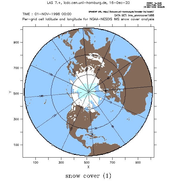
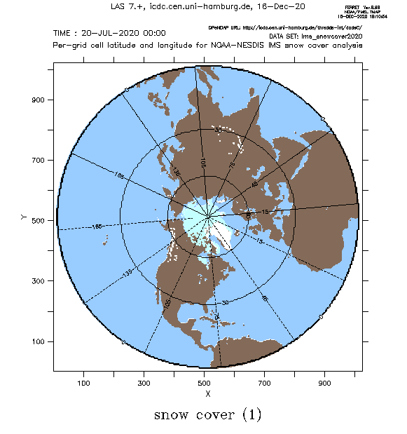
The data sets offered here are based on daily manual visual analysis of satellite data by experienced analysts of the Interactive Multisensor Snow and Ice Mapping System (IMS). By primarily using satellite data of the visible portion of the electromagnetic spectrum maps of the snow cover (on land) and the sea ice cover (over the sea) are generated at 4 km grid resolution. Satellite data used originate from polar orbiting satellites, such as e.g. MODIS, as well as geostationary satellites such as e.g. GOES and METEOSAT. Gaps due to missing daylight and/or cloud coverage are filled by including analyses of the snow cover using passive microwave satellite data; in addition the persistence of the snow cover is taken into account. Over open water the sea ice charts provided by the National Ice Center (NIC) are used in addition. More information about the data set and recently (with version 1.3) also about the data sets and data sources used is given on the IMS Webpage and in the "IMS Daily Northern Hemisphere Snow and Ice Analysis" document (see references).
This data set is unique because it is the only (long-term) data set of the snow cover which is merely based on manual visual analysis of satellite data. As such it is independent from other data sets of the snow cover such as the ESA GlobSnow snow cover at ICDC.
Note: data and coordinates are stored in separate netCDF files.
Last update of data set at ICDC: August 21, 2025.
Parameters
| Name | Unit |
|---|---|
| Snow cover | none |
| Sea ice cover | none |
Coverage, spatial and temporal resolution
Period and temporal resolution:
- 1998-11-01 to 2025-07-31
- Daily
Coverage and spatial resolution:
- Northern Hemisphere
- Spatial resolution: 24 km x 24 km (1998-2025) and 4 km x 4 km (2004-2025); polar-stereographic grid, tangential plane at 60°N
- Geographic longitude: -180°E to 180°E
- Geographic latitude: 0°N to 90°N
- Dimension: 1024 rows x 1024 columns (24 km) and 6144 rows x 6144 columns (4 km)
- Altitude: following terrain
Format:
- NetCDF
Data quality
The data set does not include uncertainty estimates. However, this is a supervised, manual data set and it can be assumed that the analysis as well as the selection of the satellite data used has been handled carefully.
In situ observations are included into the IMS snow cover analysis, however, only with small weight because local effects (urban / airport heat island, different exposure to sun in mountain valleys) can easily result in an observed snow cover which is not representative for a larger area.
The IMS analysis can be regarded conservative. Usually, the IMS sea ice extent is smaller than the one given, e.g., by NIC sea ice charts or NSIDC sea ice concentration products based on passive microwave satellite data.
More information related to possible uncertainties is given on the IMS webpage and the two references given below.
Contact
Stefan Kern
University of Hamburg
email: stefan.kern (at) uni-hamburg.deNSIDC User Services
National Snow and Ice Data Center
Boulder, CO
USA
email: nsidc (at) nsidc.org
References
- IMS Daily Northern Hemisphere Snow and Ice Analysis (pdf, not barrier free)
- IMS Daily Northern Hemisphere Snow and Ice Analysis, https://nsidc.org/data/G02156/versions/1
- Ramsay, B. H., 1998. The interactive multisensor snow and ice mapping system. Hydrological Processes, 12, 1537-1546. (pdf, not barrier free)
- Helfrich, S. R., et al., 2007. Enhancements to, and forthcoming developments in the Interactive Multisensor Snow and Ice Mapping System (IMS). Hydrological Processes, 21(12), 1576-1586. (pdf, not barrier free)
- Brown, L. C., et al., 2014, Evaluation of the Interactive Multisensor Snow and Ice Mapping System (IMS) for monitoring sea ice phenology. Rem. Sens. Environ., 147, 65-78. (pdf, not barrier free)
- Frei, A., and S-Y. Lee, 2010, A comparison of optical-based snow extent products during spring over North America. Rem. Sens. Environ., 114, 1940-1948. (pdf, not barrier free)
Data citation
Please cite the data as follows:
National Ice Center. 2008, updated daily. IMS daily Northern Hemisphere snow and ice analysis at 1 km, 4 km, and 24 km resolutions. Boulder, CO: National Snow and Ice Data Center. Digital media [last access: August 11, 2025], provided in netCDF format by ICDC, CEN, University of Hamburg.
