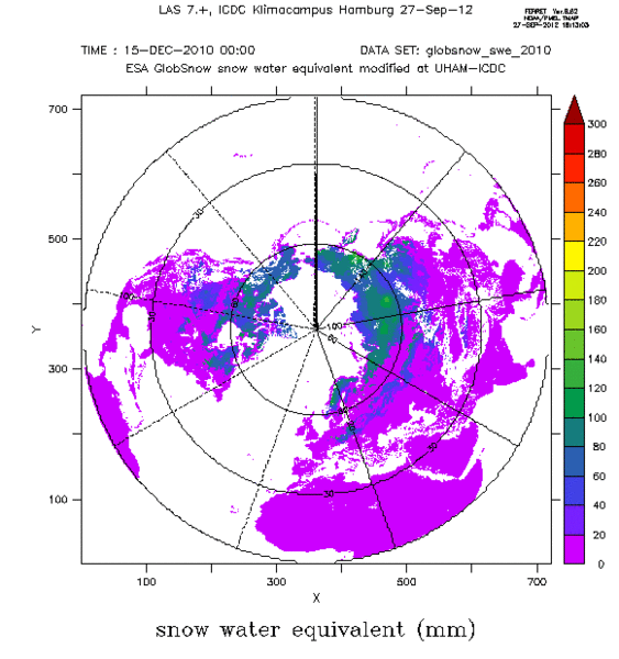
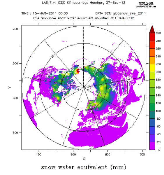
Snow water equivalent from ESA GlobSnow


Topics
- Access
- Description
- Parameters
- Coverage, spatial and temporal resolution
- Data quality
- Contact person
- References
- Data citation
Access
RESTRICTED: This link to the data set is only available for a restricted user group. The data set is only accessible in CEN/MPI net or accessible from external nets with a customer account. Please contact ICDC if you would like to access this data from outside the network.
- View SWE data at LAS
- Access SWE data via OPeNDAP
- Data access via file system: /data/icdc/ice_and_snow/globsnow_swe
Description
Scanning Multichannel Microwave Radiometer (SMMR), Special Sensor Microwave/Imager (SSM/I), and Advanced Microwave Scanning Radiometer aboard EOS (AMSR-E) data have been used to produce a data set of the snow water equivalent (SWE) gridded onto a Lambert-Azimuthal Equal Area grid with 25 km grid resolution. For each grid cell, the data set includes daily and monthly values of SWE.
First, using an empirical relationship between brightness temperatures and snow properties wet / melting snow areas are masked out. Next, snow depth is obtained from brightness temperatures for grid cells co-located with weather station data using an emission model. This model uses the snow grain size as a scalable input parameter which is chosen such that the difference between observed and computed snow depth becomes minimal. The set of grain sizes obtained together with the snow depth is used to construct a kriging interpolated distribution of the effective snow grain size which is subsequently used in the emission model inversion to obtain the snow depth distribution. Observed snow density values are finally used to convert snow depth into SWE. More details about the used approach can be found in the references in the Product User Guide (note: this guide is for version 2.0, we didn't reveice the one for version 3.0 yet).
Please also read the data quality section further below.
We are offering daily and monthly average data. For months February through May also a bias-corrected version is available.
The main product terminates 2018-12-31. A near-real-time (NRT) product with daily temporal resolution exists. We offer this product beginning in 2018-01-01 with one year overlap to the quality controlled CDR.
This is version 3.0 / and its NRT extension of the product.
Last update of data set at ICDC: September 12, 2024.
Parameters
| Name | Unit |
|---|---|
| SWE | mm |
Coverage, spatial and temporal resolution
Period and temporal resolution:
- Typically for October through May, sometimes longer
- 1979-01-01 to 2018-05-31 (Daily)
- 1979-01 to 2018-05 (Monthly)
- NRT-product: 2018-01-01 to 2024-07-31 (Daily only)
Coverage and spatial resolution:
- Northern Hemisphere
- Spatial resolution: 25 km x 25 km, EASE-Grid
- Geographic latitude: 35°N to 85°N
- Geographic longitude: 180°W to 180°E
- Dimension: 721 columns x 721 rows
- Altitude: following terrain, mountains are excluded
Format:
- NetCDF
Data quality
The data set does not contain information about the uncertainty. Users should be aware of a number of error sources; the approach itself (cannot be adapted to local snow property changes as e.g. a high fraction of depth hoar) as well as the coarse spatial resolution (grid resolution is 25 km) can cause further uncertainties if not even a bias. In particular SWE values above about 200 to 250 mm are underestimated.
Furthermore, problems arise in forested areas and mountains, in regions covered with many lakes and in areas with highly varying snow properties (dry <--> wet) or a high fraction of depth hoar relative to the total snow depth.
The retrieval approach of version 3.0 is similar to version 2.0, but with an updated snow emission model (new version of the HUT snow emission model in the SWE retrieval), updated forest canopy consideration and forest aux-data layer, and updated synoptic snow depth input data used in the retrieval (added observations and homogenized through the long term time-series).
Note, that in the data set offered here
- Years 1978-1989 have substantially more data gaps and sometimes dubious SWE distributions particularly in Europe.
- The used kriging interpolation regionally also causes artifacts. A visual inspection of the data for the respective region of interest is recommended.
More details about the data quality and about where and under which circumstances a SWE underestimation can occur can be found in the product user guide and in the scientific articles listed in the references section.
The nrt product is not as quality controlled as the CDR ending in 2018. It exhibits more missing dates but includes months June through September.
Contact
Stefan Kern
University of Hamburg
E-Mail: stefan.kern (at) uni-hamburg.deKari Luojus
Finish Meteorological Institute (FMI)
Helsinki
Finland
email: kari.luojus (at) fmi.fi
References
Literature:
- GlobSnow-2 Product User Guide Version 1.0 (pdf, not barrier free)
- Chang, A. T. C., et al., 1996. Effects of forest on the snow parameters derived from microwave measurements during the BOREAS winter field campaign. Hydrological Processes, 10, 1565-1574.
- Armstrong, R. L., and M. J. Brodzik, 2002. Hemispheric-scale comparison and evaluation of passive microwave snow algorithms. Annals of Glaciology, 34, 38-44.
- Derksen, C., et al., 2005. Evaluation of passive microwave snow water equivalent retrievals across the boreal forest / tundra transition of Western Canada. Remote Sensing of Environment, 96, 315-327.
- Foster, J. L., et al., 2005. Quantifying the uncertainty in passive microwave snow water equivalent observations. Remote Sensing of Environment, 94, 187-203.
- Gan, T. Y., et al., 2009. Comparison of snow water equivalent retrieved from SSM/I passive microwave data using artificial neural network, projection pursuit and nonlinear regressions. Remote Sensing of Environment, 113, 919-927. (pdf, not barrier free)
- Lemmetyinen, J., et al., 2009. A comparison of airborne microwave brightness temperatures and snow pack properties across the boreal forests of Finland and Western Canada. Transactions on Geoscience and Remote Sensing, 47(3), 965-978. (pdf, not barrier free)
- Takala, M., et al., 2009. Detection of snowmelt using spaceborne microwave radiometer data in Eurasia from 1979 to 2007. Transactions on Geoscience and Remote Sensing, 47(9), 2996-3007. (pdf, not barrier free)
- Takala, M., et al., 2011. Estimating northern hemisphere snow water equivalent for climate research through assimilation of space-borne radiometer data and ground-based measurements. Remote Sensing of Environment, 115(12), 3517-3529, http://doi.org/10.1016/j.rse.2011.08.014 . (pdf, not barrier free)
- Hancock, S., et al., 2013. Evaluating global snow water equivalent products for testing land surface models. Remote Sensing of Environment, 128, 107-117. (pdf, not barrier free)
- Larue, F., et al., 2017. Validation of GlobSnow-2 snow water equivalent over Eastern Canada. Remote Sensing of Environment, 194, 264-277. (pdf, not barrier free)
- Cho, E., et al., 2017, Evaluating consistency of snow water equivalent retrievals from passive microwave sensors over North centreal U.S.: SSM/I vs. SSMOS and AMSR-E vs. AMSR2, Remote Sensing, 9, 465, doi:10.3390/rs9050465.
Websites:
- ESA Globsnow Website http://www.globsnow.info
Data citation
Please cite the data as follows:
Takala, M., Luojus, K., Pulliainen, J., Derksen, C., Lemmetyinen, J., Kärnä, J.-P., Koskinen, J. and Bojkov, B., Estimating northern hemisphere snow water equivalent for climate research through assimilation of space-borne radiometer data and ground-based measurements, Remote Sensing of Environment, 115(12), 3517-3529, 2011, http://doi.org/10.1016/j.rse.2011.08.014
Pulliainen, J., Luojus, K., Derksen, C., Mudryk, L., Lemmetyinen, J., Salminen, M., Ikonen, J., Takala, M., Cohen, J., Smolander, T., and Norberg, J.: Patterns and trends of Northern Hemisphere snow mass from 1980 to 2018. Nature, 581(7808), 294-298, 2020, https://doi.org/10.1038/s41586-020-2258-0
Luojus, K., Pulliainen, J., Takala, M., Lemmetyinen, J., and Moisander, M.: GlobSnow v3.0 snow water equivalent (SWE). PANGAEA, 2020, https://doi.org/10.1594/PANGAEA.911944, last access: September 14, 2021.
or for the NRT product:
Takala, M., Luojus, K., Pulliainen, J., Derksen, C., Lemmetyinen, J., Kärnä, J.-P., Koskinen, J. and Bojkov, B., Estimating northern hemisphere snow water equivalent for climate research through assimilation of space-borne radiometer data and ground-based measurements, Remote Sensing of Environment, 115(12), 3517-3529, 2011, http://doi.org/10.1016/j.rse.2011.08.014
GlobSnow v3.0 NearRealTime (NRT) obtained from https://www.globsnow.info/swe(nrt/ [last access date: August 30, 2024]
and with the following acknowledgments:
Thanks to ICDC, CEN, University of Hamburg for data support.
