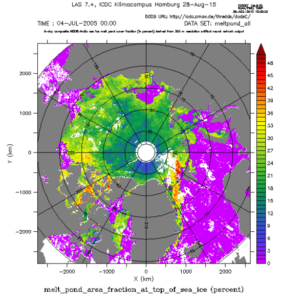
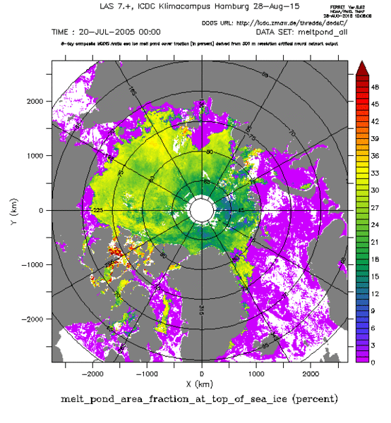
Melt pond distribution on Arctic sea ice


Topics
- Access
- Description
- Parameters
- Coverage, spatial and temporal resolution
- Data quality
- Contact person
- References
- Data citation
Access
UNRESTRICTED:
- Get Arctic melt-pond data set via FTP
- Access Arctic melt-pond data set via OPeNDAP
- Access Arctic melt-pond data set via DKRZ / CERA
RESTRICTED: This link to the data set is only available for a restricted user group. The data set is only accessible in CEN/MPI net or accessible from external nets with a customer account. Please contact ICDC if you would like to access this data from outside the network.
- View data via LAS
- Data access via file system: /data/icdc/ice_and_snow/arctic_meltponds
Description
MODIS data (MODIS Surface Reflectance 8-Day L3 Global 500m SIN Grid V005) of frequency bands 1, 3 und 4 are used in an artificial neural network to obtain the melt pond cover fraction on Arctic sea ice.
The method uses the fact that for surface types melt ponds, sea ice, snow, and open water different reflectance values are measured in the above-mentioned MODIS frequency bands. An artificial neural network has been developed. The approach of Tschudi et al. (2008) (see references) has been used to obtain a training data set of typical reflectances for selected regions and typical steps of melt pond cover development. This data set was subsequently used to train the neural network. After evaluation of the training results it has been applied to MODIS reflectances of bands 1, 3, 4 projected into a 500 m grid-cell size polar-stereographic grid to classify above-mentioned surface types.
The surface type distribution obtained is analysed and converted into a 12.5 km x 12.5 km grid-cell size product, i.e. the melt-pond fraction per grid cell. The data set contains the melt-pond fraction per grid cell.
In order to obtain a relative melt-pond fraction, i.e. relative to the actual sea-ice concentration, the melt-pond fraction needs to be divided by the sea-ice concentration (here: 1 minus open water fraction).
The data set offered comprises, on the one hand, the full set of melt pond fraction, its standard deviation, the open water fraction and the number of usable 500 m grid cells per 12.5 km grid cell. Those 12.5 km grid cells with less than 10% usable 500 m grid cells or more than 85% open water fraction are flagged. On the other hand, we offer in addition melt pond fraction, its standard deviation and the open water fraction for almost clear-sky areas, i.e. 12.5 km grid cells with more than 90% usable 500 m grid cells; areas with more than 85% open water fraction are again flagged.
This is version v02 of this data set. It differs from version v01 by a bias correction of the melt pond cover fraction and the open water fraction which were biased by 8% and 3%, respectively in the old version.
This data set is a CliSAP/KlimaCampus Product.
Last update of data set at ICDC: August 27, 2015.
Parameters
| Name | Range |
|---|---|
| Melt pond fraction | 0-100% |
| Melt pond fraction standard deviation | 0-100% |
| Number of 500 m resolution grid cells used | 0-625 |
| Open water fraction | 0-100% |
| Melt pond fraction "clear sky" | 0-100% |
| Melt pond fraction standard deviation "clear sky" | 0-100% |
| Open water fraction "clear sky" | 0-100% |
Coverage, spatial and temporal resolution
Period and temporal resolution:
- 2000 - 2011
- 8-day-composites, start May 9, end September 13 (16 maps / year)
Coverage and spatial resolution:
- Northern hemisphere north of 60°N
- Spatial resolution: 12.5 km x 12.5 km, polar-stereographic grid of the NSIDC, tangential plane at 70°N (see references)
- Geographic latitude: 60°N to 90°N
- Geographic longitude: 0°E to 360°E
- Dimension: 608 columns x 896 rows
- Altitude: 0.0 m
Format:
- NetCDF
Data quality
In addition to the melt pond cover fraction, information about the number of valid 500 m grid resolution melt pond cover fractions per (here) 12.5 km grid cell of the product and the standard deviation of this fraction is given. A low standard deviation and/or high number of valid observations indicate a high data quality, while a high standard deviation and/or a small number of valid observations indicate a less reliable product.
The obtained melt pond cover fractions have been evaluated with a number of independent data, e.g., ship observations, air-borne observations and high-resolution visible satellite imagery. Some results of these evaluation activities are summarized in Rösel et al. (2012) (see references). Melt pond cover fraction from independent data and obtained from MODIS data agree with each other within the uncertainty range given by the different spatial-temporal observation scales.
The bias of 8% in melt pond cover fraction and 3% in open water fraction found for version v01 has been corrected in this new version v02 of this data set.
Note: The data files for 2009.08.13 contain zero melt-pond fraction values; thisi is wrong, please discard the data of this 8-day period.
Contact
Anja Rösel
German Aerospace Center
email: anja.roesel (at) dlr.deLars Kaleschke
Alfred Wegener Institute for Polar and Marine Research / Bremerhaven
email: lars.kaleschke (at) awi.deStefan Kern
University of Hamburg
email: stefan.kern (at) uni-hamburg.de
References
Literature:
- Rösel, A., et al. (2012), Melt ponds on Arctic sea ice determined from MODIS satellite data using an artificial neural network, The Cryosphere, 6, 431-446, 2012. (pdf, not barrier free)
- Documentation for MODIS Melt Pond Product, A. Rösel and S. Kern (2011) (pdf, not barrier free)
- Tschudi, M. A., et al., Derivation of melt pond coverage on Arctic sea ice using MODIS observations, Remote Sensing of Environment (2008). (pdf, not barrier free)
- Ph.D. Thesis: A. Rösel, Detection of Melt Ponds on Arctic Sea Ice with Optical Satellite Data, Hamburg Studies on Maritime Affairs 25 DOI 10.1007/978-3-642-37033-5 1, © Springer-Verlag Berlin Heidelberg 2013
- Mäkynen, M., et al., On the Estimation of Melt Pond Fraction on the Arctic Sea Ice With ENVISAT WSM Images, IEEE TRANSACTIONS ON GEOSCIENCE AND REMOTE SENSING, VOL. 52, NO. 11, 2014. (pdf, not barrier free)
- Zhang, Jinlun, et al., Melt pond conditions on declining Arctic sea ice over 1979-2016: Model development, validation and results. J. Geophys. Res.-Oceans, 123, 7983-8003, http://doi.org/10.1029/2018JC014298 , 2018.
- The former version of this data set, v01, DOI:10.1594/WDCC/MODIS__Arctic__MPF, http://dx.doi.org/10.1594/WDCC/MODIS__Arctic__MPF
Websites:
- polar-stereographisches Gitter des NSIDC, https://nsidc.org/data/polar-stereo/tools_geo_pixel.html
Data citation
Please cite the data as follows:
Rösel, Anja; Kaleschke, Lars; Kern, Stefan (2015). Gridded Melt Pond Cover Fraction on Arctic Sea Ice derived from TERRA-MODIS 8-day composite Reflectance Data bias corrected Version 02, https://www.cen.uni-hamburg.de/en/icdc/data/cryosphere/arctic-meltponds.html . World Data Center for Climate (WDCC) at DKRZ. https://doi.org/10.1594/WDCC/MODIS__Arctic__MPF_V02
and refer to the paper by Roesel et al. (2012) .
