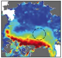
Arctic Sea-Ice thickness from ICESat data

Topics
- Access
- Description
- Parameters
- Coverage, spatial and temporal resolution
- Data quality
- Contact person
- References
- Data citation
Access
UNRESTRICTED:
- On request. Please contact Stefan Kern.
Description
Travel time measurements of laser pulses emitted by the GLAS instrument aboard the ICESat satellite allow the determination of the sea-ice freeboard height with centimeter accuracy. Under certain assumptions and taking additional data like the distribution of multiyear ice and the snow depth on sea ice into account (see references), the freeboard height can be converted into an ice thickness.
The data set available here comprises data from 10 ICESat measurement periods, i.e. a time series of two measurements of the Arctic sea-ice thickness distribution every winter (October/November and February/March) for winters 2003/04 until 2007/08 with a grid resolution of 25 km x 25 km.
This data is a mean / composite over the considered ICESat measurement period. The exact duration of these period is given in Kwok et al., 2009 (see references); typically the periods comprise 35 days in February/March (2007: March/April) bzw. October/November (2003: September-November).
Data are stored as 4byte floating point values. The header contains the number of grid cells with valid values (2byte integer), followed by geographic latitude and longitude, x and y, and the ice thickness; x and y are the distance (in km) of the center of each grid cell to the center of the NSIDC grid.
A routine (IDL) to read, display and store the data as an image can be downloaded (see references).
Last update of data set at ICDC:
Parameters
| Name | Unit |
|---|---|
| sea-ice thickness | cm |
Coverage, spatial and temporal resolution
Period and temporal resolution:
- 2003 to 2008, two measurement periods per year: fall and late winter
- quasi-monthly (about 35 days), see description
Coverage and spatial resolution:
- Northern hemisphere
- Spatial resolution: 25 km x 25 km, polar-stereographic grid of the NSIDC, centered at 70°N
- Geographic longitude: 0°E to 360°E
- Geographic latitude: about 60°N to 90°N
- Dimension:
- Altitude: 0.0 m
Format:
- Binary
Data quality
This data give a measure about the mean monthly Arctic sea-ice thickness distribution at two points during the seasonal cycle: October/November, i.e. about one month after freeze-up has started, and February/March, i.e. when sea ice extent is at its maximum but sea-ice thickness will continue to increase for 1-2 months.
The data set does not contain error estimates
Kwok et al. found a mean uncertainty of the sea ice thickness of about 0.7 m using an error propagation. Sea-ice draft estimated from ICESat data on the one hand and measured at mooring on the other hand agree within 0.5 m.
However, it can be expected that the uncertainty can be considerably higher than the two numbers given above, because of the used assumptions and because of gaps in our knowledge concerning snow properties as its depth and their variability.
We recommend to take a look at the references and/or get into discussion with us or Ron Kwok directly.
Contact
Ron Kwok
Jet Propulsion Laboratory, Pasadena, CA, U.S.A.
email: rkwok01 (at) gmail.comStefan Kern
ICDC / CEN / University of Hamburg
E-Mail: stefan.kern"AT"uni-hamburg.de
References
Literature:
- Kwok, R., G. F. Cunningham, H. J. Zwally, and D. Yi (2007), Ice, Cloud, and land Elevation Satellite (ICESat) over Arctic sea ice: Retrieval of freeboard, J. Geophys. Res., 112, C12013, doi:10.1029/2006JC003978.
- Kwok, R., and G. F. Cunningham (2008), ICESat over Arctic sea ice: Estimation of snow depth and ice thickness, J. Geophys. Res., 113, C08010, doi:10.1029/2008JC004753.
- Kwok, R., G. F. Cunningham, M. Wensnahan, I. Rigor, H. J. Zwally, and D. Yi (2009), Thinning and volume loss of the Arctic Ocean sea ice cover: 2003–2008, J. Geophys. Res., 114, C07005, doi:10.1029/2009JC005312.
Websites:
- IDL routine to read, display and store the data as an image: prog-read-icesat-icethk
Data citation
Please cite the data as follows:
Please contact Ron Kwok ronald.kwok"AT"jpl.nasa.gov for information about how to cite these data.
and with the following acknowledgments:
Thanks to ICDC, CEN, University of Hamburg for data support.
