Snow water equivalent from NSIDC
Topics
- Access
- Description
- Parameters
- Coverage, spatial and temporal resolution
- Data quality
- Contact person
- References
- Data citation
Access
RESTRICTED: This link to the data set is only available for a restricted user group. The data set is only accessible in CEN/MPI net or accessible from external nets with a customer account. Please contact ICDC if you would like to access this data from outside the network.
- Access SWE data via OPeNDAP
- Data access via file system: /data/icdc/ice_and_snow/nsidc_swe
Description
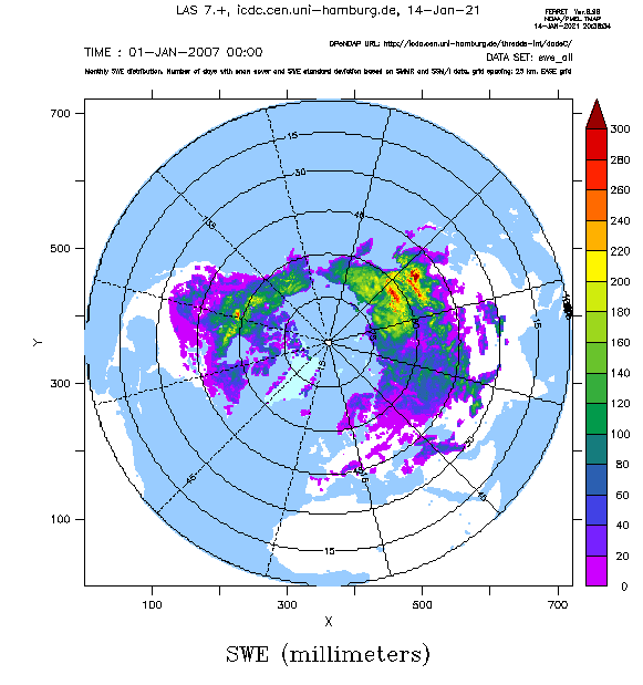
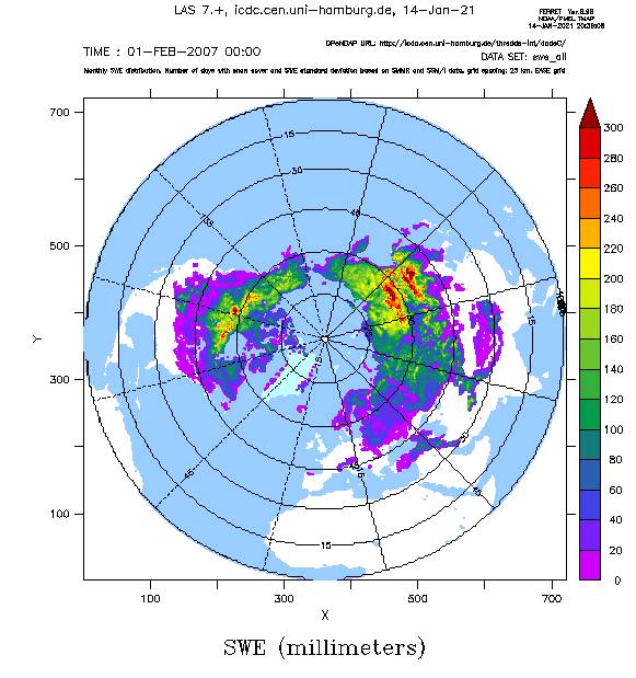
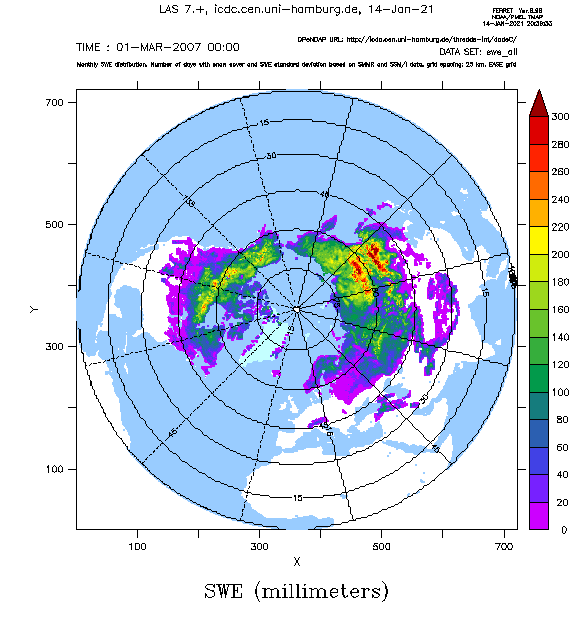
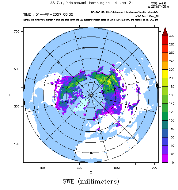
Scanning Multichannel Microwave Radiometer (SMMR) and Special Sensor Microwave/Imager (SSM/I) data have been used to produce a SWE data set gridded onto a Lambert-Azimuthal Equal Area grid with 25 km grid resolution. The SWE data available here have been computed using re-processed brightness temperature observations that have been corrected in advance for inter-sensor differences. The data set includes monthly values of SWE and its standard deviation, together with the number of days (within a month) with snow cover in the respective grid cell.
The NSIDC documentation (see references) informs about the used approach, the methods used to optimize the data set including the error estimation, and a few aspects about the validation.
We note that some regions are subject to large discrepancies between the observed and the retrieved SWE values. Reasons for this are given below in sections "data quality" and "references".
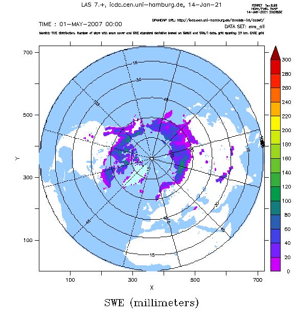
The maps on top of this page exemplify the SWE distribution in the Northern Hemisphere for the months 11/2006 to 04/2007.
We can also provide data from the southern hemisphere upon request.
Last update of data set at ICDC:
Parameters
| Name | Unit |
|---|---|
| SWE | mm |
| Days with snow cover per month | number |
| SWE standard deviation | mm |
Coverage, spatial and temporal resolution
Period and temporal resolution:
- 11/1978 to 05/2007
- Monthly
Coverage and spatial resolution:
- Northern Hemisphere
- Spatial resolution: 25 km x 25 km, EASE Grid
- Geographical latitude: north of about 18°N
- Geographical longitude: 0°E to 360°E
- Dimension: 721 columns x 721 rows
- Altitude: following terrain
Format:
- NetCDF
Data quality
The data set contains information about the uncertainty in the retrieved SWE. However, users should be aware of additional error sources; the approach itself (cannot be adapted to local snow property changes as e.g. a high fraction of depth hoar) as well as the coarse spatial resolution (grid resolution is 25 km) can cause further uncertainties if not even a bias.
Furthermore, problems arise in forested areas and mountains, in regions covered with many lakes and in areas with highly varying snow properties (dry <--> wet) or a high fraction of depth hoar relative to the total snow depth.
We recommend the publications listed in references down below for further reading.
Contact
Stefan Kern
ICDC / CEN / University of Hamburg
E-Mail: stefan.kern"AT"uni-hamburg.deNSIDC User Services
National Snow and Ice Data Center
CIRES, 449 UCB
University of Colorado
Boulder, CO 80309-0449
USA
email: nsidc (at) nsidc.org
References
Literature:
- Chang, A. T. C., et al., 1987. Nimbus-7 SMMR derived glbal snow cover parameters. Annals of Glaciology, 9, 39-44.
- Chang, A. T. C., et al., 1996. Effects of forest on the snow parameters derived from microwave measurements during the BOREAS winter field campaign. Hydrological Processes, 10, 1565-1574.
- Armstrong, R. L., and M. J. Brodzik, 2002. Hemispheric-scale comparison and evaluation of passive microwave snow algorithms. Annals of Glaciology, 34, 38-44.
- Derksen, C., et al., 2005. Evaluation of passive microwave snow water equivalent retrievals across the boreal forest / tundra transition of Western Canada. Remote Sensing of Environment, 96, 315-327.
- Foster, J. L., et al., 2005. Quantifying the uncertainty in passive microwave snow water equivalent observations. Remote Sensing of Environment, 94, 187-203.
- Gan, T. Y., et al., 2009. Comparison of snow water equivalent retrieved from SSM/I passive microwave data using artificial neural network, projection pursuit and nonlinear regressions. Remote Sensing of Environment, 113, 919-927.
- Lemmetyinen, J., et al., 2009. A comparison of airborne microwave brightness temperatures and snow pack properties across the boreal forests of Finland and Western Canada. Transactions on Geoscience and Remote Sensing, 47(3), 965-978.
- Nolin, A. W. 2010. Recent advances in remote sensing of seasonal snow. J. Glaciol., 56(200), 1141-1150.
- Cho, E., et al., 2017, Evaluating consistency of snow water equivalent retrievals from passive microwave sensors over North centreal U.S.: SSM/I vs. SSMOS and AMSR-E vs. AMSR2, Remote Sensing, 9, 465, doi:10.3390/rs9050465.
Websites:
- NSIDC, Global Monthly EASE-Grid Snow Water Equivalent Climatology, Version 1, https://nsidc.org/data/NSIDC-0271/versions/1
Data citation
Please cite the data as follows:
Armstrong, R., M. Brodzik, K. Knowles, and M. Savoie. 2005. Global Monthly EASE-Grid Snow Water Equivalent Climatology. [indicate subset used]. Boulder, Colorado USA: NASA National Snow and Ice Data Center Distributed Active Archive Center. http://dx.doi.org/10.5067/KJVERY3MIBPS, distributed in netCDF format by the Integrated Climate Data Center (ICDC), CEN, University of Hamburg, Hamburg, Germany.
and with the following acknowledgments:
Thanks to ICDC, CEN, University of Hamburg for data support.
