Sea-ice parameters from ship observations


Topics
- Access
- Description
- Parameters
- Coverage, spatial and temporal resolution
- Data quality
- Contact person
- References
- Data citation
Access
UNRESTRICTED:
- Get Original ASPeCt data (1980-2005) via HTTP from ASPeCt Website: ASCII
- Download recent, standardized ASPeCt data (2002-2019, Antarctic) from ICDC: ASCII | NetCDF
- Download standardized ASSIST/IceWatch data (2002-2019, Arctic): ASCII | NetCDF
Description
The data sets referred to on this web page are collections, which are described in the files data sources Northern Hemisphere and data sources Southern Hemisphere (see references). The collections contain visual ship-based sea-ice observations carried out from the ship's bridge while the ship cruises through the sea ice. These observations have been standardized according to the ASPeCt protocol, which is described on the ASPeCt Website, and for the Arctic additionally according to the ASSIST/IceWatch protocol (see Hutchings, J., et al., 2011 in the references). These observations contain the ship's position, the day and time of the observation (hourly, with an observation radius around the ship of about 1 km), the total sea ice concentration, the partial concentrations of the three thickest sea ice types, and for these, respectively, thickness, type, fraction and height of deformation sea ice, floe size, snow properties and depth, and for the Arctic also melt-pond fraction.
Please refer to the ASPeCt and ASSIST/IceWatch website for further information, and an ASPeCt tutorial that allows to learn how sea-ice observations are carried out according to the ASPeCt protocol (see references).
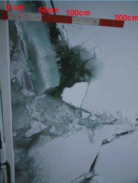
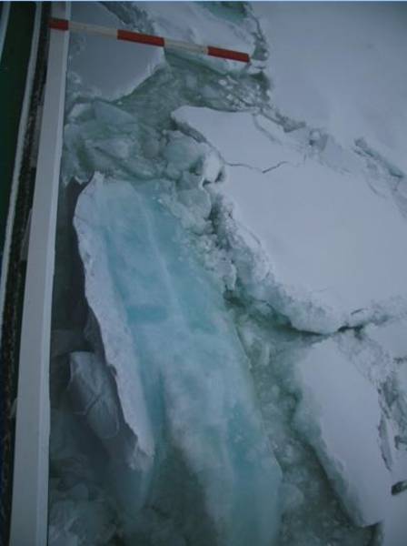
The two pictures at the top illustrate how the sea ice thickness is estimated by looking at the tilted ice floe and a scale attached to the ship's hull (in this case the research icebreaker Polarstern).
There are two kinds of this data offered here:
- The first kind is the original ASPeCt observations data file covering expeditions into the Antarctic of years 1980 through 2005 (see Worby et al., 2008 in the references).
- The second kind are data files with a collection of the more recent observations, hence extending the original ASPeCt observation data set through 2019, and adding observations collected in the Arctic (Data of years 2006 through 2019 for the Arctic are part of the data set of Hutchings, 2018, see references). Cruises considered in the current release at ICDC are from May 2002 through December 2019.
The header of the data files informs about the parameters included and in which column they are given in the data file. Data of different cruises are given per cruise, mostly in chronological order. Different cruises can be discriminated by means of a cruise acronym. See references for more information.
The netCDF data files contain all auxiliary information in the global attributes.
Last update of data set at ICDC: October 2, 2020.
Parameters
| Name | Unit / Range | Comment |
|---|---|---|
| Total sea ice concentration | 1/10 | |
| Partial sea ice concentration | !/10 | primary (=thickest) ice type |
| Sea ice thickness | m | |
| Sea ice type | ASPeCt code | |
| Floe size * | ASPeCt code | |
| Snow type | ASPeCt code | also called "surface type" |
| Snow depth | m | |
| Ridged ice fraction | 0 ... 1 | |
| Ridge height | m | |
| Stage of melt * | ASSIST/IceWatch Code | |
| Melt pond concentration * | % | |
| Partial sea ice concentration | 1/10 | secondary (= next thickest) ice type |
| Sea ice thickness | m | |
| Sea ice type | ASPeCt code | |
| Floe size * | ASPeCt code | |
| Snow type | ASPeCt code | also called "surface type" |
| Snow depth | m | |
| Ridged ice fraction | 0 ... 1 | |
| Ridge height | m | |
| Stage of melt * | ASSIST/IceWatch Code | |
| Melt pond concentration * | % | |
| Partial sea ice concentration | 1/10 | tertiary (= next thickest) ice type |
| Sea ice thickness | m | |
| Sea ice type | ASPeCt code | |
| Floe size * | ASPeCt code | |
| Snow type | ASPeCt code | also called "surface type" |
| Snow depth | m | |
| Ridged ice fraction | 0 ... 1 | |
| Ridge height | m | |
| Stage of melt * | ASSIST/IceWatch Code | |
| Melt pond concentration * | % | |
| Other ice type thin * | ASPeCt code | Thinner than tertiary |
| Other ice type thick * | ASPeCt code | Thicker than tertiary but < 10% coverage |
| Observer and Comments* | |
|---|---|
| Significant weather | WMO code |
| Visibility | WMO code |
| Total cloud cover | 1 / 8 |
| Wind speed | m / s |
| Wind direction | degrees |
| Air temperature | °C |
| Water temperature | °C |
| Relative humidity * | % |
| Air pressure * | hPa |
| Ship speed * | knots |
| Ship heading * | degrees |
| Other comments | |
Coverage, spatial and temporal resolution
Period and temporal resolution:
- 1980 to 2005 / 2002 to 2019
- irregular temporal resolution, often hourly, for different ship expeditions for different seasons
Coverage and spatial resolution:
- Southern & Northern hemisphere, along ship expedition routes
- Spatial resolution: irregular, depending on ships speed, 1 observation represents an area of 1 kilometre radius around the ships' position.
- Geographic longitude: irregular, between 0° to 360°
- Geographic latitude: irregular, Southern Hemisphere: between 50°S and 80°S; Northern Hemisphere: between 50°N and 90°N
- Dimension: irregular, depends on length of and observation interval during the ship expeditions
- Altitude: 0.0 m
Format:
- NetCDF (2002-2019)
- ASCII, comma separated columns
- Number and content of columns differ between the "original" ASPeCt data set (ending in 2005) and the two more recent data sets (2002-2019). Also between these new, more recent data sets number and content of columns differ. Reasons are: differerent ice types, different forms to fill in the data, different meteorological observations. Variables listed under Parameters denoted with a * are only available for the Northern Hemisphere.
Data quality
The "original" ASPeCt data set (1980-2005) has undergone quality control as described on the ASPeCt web page and in Worby et al., 2008 (see references) . This data set has not been modified.
The two more recent data sets have been quality checked against outliers and unphysical values; double readings have been deleted; cells with missing observations have been filled with missing values being either -9, -9.9, or 99.9 depending on the variable. Observations have been standardized with respect to their unit and representation in the data sets. Information about sediments and algae have been discarded - as well as information about the type of topography. For translation of ASPeCt or ASSIST/IceWatch codes of, e.g., ice type or snow type, please take a look at the documents under references. Coded weather information of, e.g., significant weather or visibility can be taken from the files with additional weather and visibility information (see references).
This data is based on a visual estimation of the mentioned parameters by individual people on the individual cruises. These people are either well trained observers or beginners, trained by the available tutorial (see references) and senior observers. This heterogeneity in observation skills potentially has an impact on the quality of the observations. The accuracy is therefore quite low: sea ice concentrations are given in 10% intervals; the sea ice thickness is given in 10 cm intervals - unless the sea ice is thinner than 20 cm, when the accuracy is 2-5 cm. The accuracy of the snow depth on sea ice is around 5-10 cm - unless the snow is thinner than 10 cm, when the accuracy is possibly 2-5 cm.
Note that
- the cruise track is often located in leads and hence in thinner sea ice than is often typical for the region of the cruise --> negative bias in sea-ice thickness and snow depth as well as fraction of deformed ice and ridge height, and - during summer - also in the sea-ice concentration
- sea ice floes rafted on top or below each other might detach while the ship passes by and might thus not be visible along the ship's hull --> negative bias in sea-ice thickness.
- it takes about 10 minutes to carry out an ice observation according to the ASPeCt protocol; therefore the area represented by one ASPeCt observations is elliptic rather than circular due to the (mostly) continued motion of the ship.
- particularly during summar & fall low level clouds and fog often hampers visibility; incorporation of information about the visibility transferred along with the data could help to discard biases due to visibility.
Contact
Stefan Kern
ICDC / CEN / University of Hamburg
email: stefan.kern (at) uni-hamburg.de
References
Literature:
- Worby, A. P., and I. Allison, 1999, A technique for making ship-based observations of Antarctic sea-ice thicknes and characteristics - Part I: Observational Techniques and Results. (pdf, not barrier free)
- Worby, A. P., and V. Dirita, 1999, A technique for making ship-based observations of Antarctic sea-ice thicknes and characteristics - Part II: User Operating Manual. (pdf, not barrier free)
- Worby et al., Thickness distribution of Antarctic sea ice, 2008 (pdf, not barrier free)
- Hutchings, J., et al., 2011, Ice Watch: Standardizing and expanding Arctic ship based sea-ice observations. (pdf, not barrier free)
- Hutchings, J., et al., 2018, The Ice Watch Manual, draft version 4.1, June 2018. (pdf, not barrier free)
- Hutchings, J. K., 2018, Shipborne visual observations of Arctic sea ice. PANGAEA, https://doi.org/10.1594/PANGAEA.889209
- Tutorial to understand the ASPeCt protocol (pdf in zip archive, not barrier free)
- Data Sources Northern Hemisphere (txt)
- Data Sources Southern Hemisphere (txt)
- Additional information about conversion of coded into physical information (txt)
- file with additional weather information, weather.txt
- file with additional visibility information, visibility.txt
Websites:
- ASPeCt Webpage: https://data.aad.gov.au/aspect/
- https://data.aad.gov.au/metadata/records/ASPECT_2007_2013
- ASSIST/IceWatch Webpage: https://icewatch.met.no/
- Overview of ASPeCt: http://aspect.antarctica.gov.au/
- Data from ASPeCt Website, http://aspect.antarctica.gov.au/data
- WDC, Metadata for 'ESA-CCI_Phase2_Standardized_Manual_Visual_Ship-Based_SeaIceObservations_v02', https://doi.org/10.26050/WDCC/ESACCIPSMVSBSIOV2
Data citation
Please cite the data as follows:
The original ASPeCt data set for the Southern Hemisphere (1980-2005):
ASPeCt ship-based sea-ice cover parameter data were provided by the SCAR Antarctic Sea Ice Processes and Climate (ASPeCt) program (www.aspect.aq)
and the paper by Worby et al. (2008) .
For the two more recent data sets (2002-2019):
Kern, Stefan (2020). ESA-CCI_Phase2_Standardized_Manual_Visual_Ship-Based_SeaIceObservations_v02. Integrated Climate Data Center (ICDC: https://icdc.cen.uni-hamburg.de) at CEN, University of Hamburg, and World Data Center for Climate (WDCC) at DKRZ. https://doi.org/10.26050/WDCC/ESACCIPSMVSBSIOV2
and with the following acknowledgments:
Thanks to ICDC, CEN, University of Hamburg for data support.
