GECCO3

Topics
- Access
- Description
- Parameters
- Coverage, spatial and temporal resolution
- Data quality
- Contact person
- References
- Data citation and License
Access
UNRESTRICTED:
- Get data via THREDDS: all files of both versions with wget-script
- Access data via OPeNDAP: Interpolated fields on a regular 1x1° grid | Fields on the native model grid
- DOI: 10.25592/uhhfdm.17973 1 degree, 6 months relaxation
- DOI: 10.25592/uhhfdm.14187 native grid, 6 months relaxation
- DOI: 10.25592/uhhfdm.17975 1 degree, 2 months relaxation
- DOI: 10.25592/uhhfdm.17977 native grid, 2 months relaxation
RESTRICTED: This link to the data set is only available for a restricted user group. The data set is only accessible in CEN/MPI net or accessible from external nets with a customer account. Please contact ICDC if you would like to access this data from outside the network.
- Data access via file system: /data/icdc/ocean_syntheses/GECCO3
Description
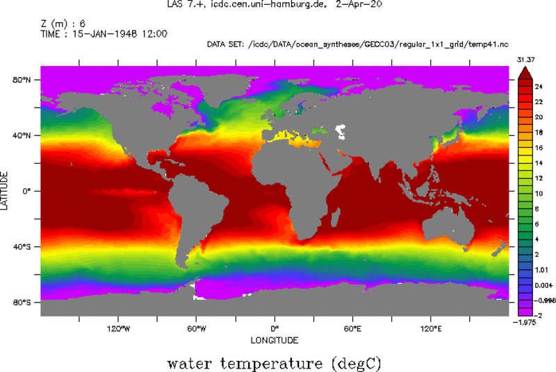
The GECCO3 ocean synthesis is the German contribution of the Estimating the Circulation and Climate of the Ocean project (ECCO, see references) and is the new version of the GECCO2 synthesis already available at ICDC. The synthesis also uses the adjoint method to adjust the initial temperature and salinity in 1948 together with the air temperature, humidity, precipitation, shortwave radiation, and zonal and meridional wind every 10 days to bring the model into consistency with the data, which derive from the EN4.2.1 data base AVISO along track SLA, DTU10 mean sea surface minus GOCO5s geoid to yield the mean dynamic topography, HadISST SST, and the WOA18 climatology. The global model is based on the MITgcm model, has 40 levels, and uses the horizontal and vertical grid of the ocean component of MPI-ESM in the MR/HR configuration, which is with nominally 0.4° resolution eddy-permitting. The bathymetry is also adopted from this configuration. The background atmospheric state is taken from the 6 hourly NCEP/NCAR Reanalysis 1.
GECCO3 and GECCO3S6m
The GECCO3 synthesis covers the period 1948-2018 and, unlike GECCO2, is optimized over only one assimilation window. The state after 41 iterations is available. There are two versions of the synthesis, which differ in the time constant of the relaxation of the surface salinity. The product with the extension 41 uses a relaxation time of 60 days, whereas for the extension 41S6m a time of 180 days was used. Globally and averaged over all data types, there is a slight advantage for the stronger relaxation. However, an evaluation with ESA-CCI surface salinity data for the years 2011-2018 showed a somewhat more realistic variability with less relaxation. In other variables that were examined, mainly differences between the two products on multi-decade time scales were found. The difference between the products gives an impression of the robustness of the estimate, but it must be taken into account that only one aspect was changed. Overall, the GECCO3S6m version can be recommended.
Model: MITgcm
Resolution: 0.4°, 40 z-levels, partial cells
Data assimilated: EN4.2.1 T/S (XBT corrected)+ AVISO along track SLA , GOCO5s MDT, HadISST SST, WOA18 climatology
Assimilation method: 4D-VAR (adjoint) method
Forcing and relaxation used: NCEP RA1 atm. Fields, Bulk formulae, Large and Yeager, 2009
Last update of data set at ICDC:
Parameters
| Name | Unit | filename |
|---|---|---|
| water temperature | deg C | temp* |
| sea surface height | m | zeta* |
| salinity | g/kg | salt* |
| net shortwave flux | W/m^2 | qsw* |
| totel heat flux | W/m^2 | qnet* |
| fresh water flux | kg/s/m^2 | emp* |
| meridional wind stress | N/m^2 | fv* |
| zonal wind stress | N/m^2 | fu* |
| u velocity | m/s | u* |
| v velocity | m/s | v* |
| w velocity | m/s | w* |
| bottom pressure | Pa | bp* |
| effective sea ice thickness | m | heff* |
| sea ice area | % | area* |
| meridional ice velocity | m/s | vice* |
| zonal ice velocity | m/s | uice* |
| GM X Streamfunction | m^2/s | gmpsix |
| GM Y Streamfunction | m^2/s | gmpsiy |
| Diffusivity | m^2/s | diff |
| Viscosity | m^2/s | visc |
| HBL Mixing Layer | m | hbl |
| Heat Flux (including relaxation) | W/m² | tflux |
| Salt Flux (including relaxation) | kg/s | sflux |
| Snow Height | m | hsnow |
Coverage, spatial and temporal resolution
Period and temporal resolution:
- 1948-2018
- monthly
- SSH (daily upon request)
Coverage and spatial resolution:
- Global
- Spatial resolution: 1°x1° (interpolated product)
- Dimension: 360x180x40
- Altitudes: 40 depth levels
Format:
- NetCDF4
Data quality
Variational methods fit the trajectory best during the middle section of the assimilation period. During the first few years spin-up effects are noticeable such that the variability during this period should be considered with care. Changes in the densities and type of assimilated data leave signatures in the product, in particular noticeable in year 1992 and at the beginning of the 2000s during the advent of altimeter and Argo data.
Contact
Armoin Köhl
CEN / University of Hamburg
E-Mail: armin.koehl (at) uni-hamburg.deRemon Sadikni
ICDC / CEN / University of Hamburg
E-Mail: remon.sadikni"AT"uni-hamburg.de
References
Literature:
- Köhl, A. (2020), Evaluating the GECCO3 1948-2018 Ocean Synthesis - a configuration for initializing the MPI-ESM climate model, Q. J. R. Met. Soc., doi: 10.1002/qj.3790. https://doi.org/10.1002/qj.3790
Websites:
- ECCO, www.ecco-group.org
- ESA-CCI surface salinity data, http://cci.esa.int/salinity
Data citation, License, and Acknowledgments
Please contact Armin Köhl: armin.koehl (at) uni-hamburg.de for citation information.
and with the following acknowledgments:
Thanks to ICDC, CEN, University of Hamburg for data support.
License
The data was published under the Creative Commons Attribution 4.0 International License (CC-BY-4.0).
