GECCO2

Topics
- Access
- Description
- Parameters
- Coverage, spatial and temporal resolution
- Data quality
- Contact person
- References
- Data citation and License
Access
UNRESTRICTED:
- Get GECCO2 grid data via FTP: Interpolated fields on a regular 1x1° | native model grid (Important: Please read the information on the versions in the description.)
- Access GECCO2 grid data via OPeNDAP: Interpolated fields on a regular 1x1° | native model grid (Important: Please read the information on the versions in the description.)
RESTRICTED: This link to the data set is only available for a restricted user group. The data set is only accessible in CEN/MPI net or accessible from external nets with a customer account. Please contact ICDC if you would like to access this data from outside the network.
- Data access via file system: /data/icdc/ocean_syntheses/GECCO2
Description
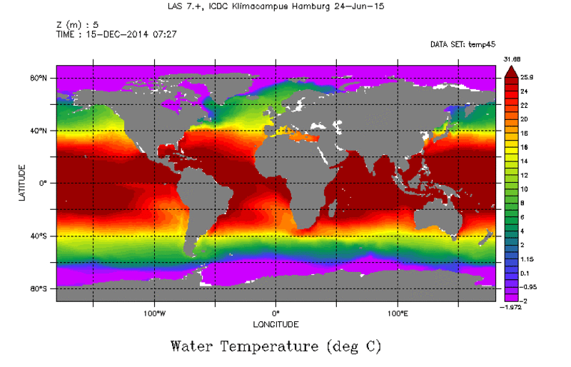
The GECCO2 ocean synthesis is the German contribution of the Estimating the Circulation and Climate of the Ocean project (ECCO, see references). The synthesis uses the adjoint method to adjust the initial temperature and salinity in 1948 together with the air temperature, humidity, precipitation, and zonal and meridional wind every 10 days to bring the model into consistency with the data, which derive from the EN3v2 data base AVISO along track SLA , GOCO mean dynamic topography, HadISST, AMSRE SST, and the WOA09 climatology. The global model is based on the MITgcm model, has 50 levels, and uses zonally 1 degree and meridionally varying higher resolution. The background atmospheric state is taken from the 6 hourly NCEP/NCAR Reanalysis 1.
The GECCO2 synthesis covers the period 1948-2011. For the last iterations, the synthesis was partitioned into overlapping 5 year windows. Since only the initial condition in 1948 is allowed to change in GECCO2, the atmospheric state is the only control for all windows except for the first one. The synthesis was extended twice, into the year 2013 and 2014, respectively, by taking the initial conditions of iteration 28 from the end of 2008.
Model: MITgcm
Resolution: 1x1/3°, 50 z-levels, partial cells
Data assimilated: EN3_v2a T/S (XBT corrected)+ AVISO along track SLA , GOCO MDT, HadISST, AMSRE SST, WOA09 climatology
Assimilation method: 4D-VAR (adjoint) method
Forcing and relaxation used: NCEP RA1 atm. Fields, Bulk formulae, Large and Yeager, 2009
Information on Versions
- Dec 15, 2017 New version online: update of the years 2011-2016, the years until 2010 have not been changed compared to the previous version (29_34_55). The previous version is still available under "old_versions" (native grid: only the updated years 2011-2014, 1°x1° grid: complete files)
- Oct 5, 2017 New version online: due to modified initial conditions for the year 2011, the years from 2011-2014 were updated.
- Nov 27, 2015 New Version online that replaced the previous one: Since the year 2014 used a wrong scaling factor for precipitation, the last assimilation window 2011-2014 was repeated after correcting the error.
- Warning: Do not use the grid information inside the single cdf-Files but the grid from the file "grid.cdf"
Last update of data set at ICDC: 2017
Parameters
| Name | Unit | filename |
|---|---|---|
| water temperature | deg C | temp* |
| sea surface height | m | zeta* |
| salinity | g/kg | salt* |
| net shortwave flux | W/m^2 | qsw* |
| totel heat flux | W/m^2 | qnet* |
| fresh water flux | kg/s/m^2 | emp* |
| meridional wind stress | N/m^2 | fv* |
| zonal wind stress | N/m^2 | fu* |
| u velocity | m/s | u* |
| v velocity | m/s | v* |
| w velocity | m/s | w* |
| bottom pressure | Pa | bp* |
| effective sea ice thickness | m | heff* |
| sea ice area | % | area* |
| meridional ice velocity | m/s | vice* |
| zonal ice velocity | m/s | uice* |
Coverage, spatial and temporal resolution
Period and temporal resolution:
- 1948-2016
- monthly
Coverage and spatial resolution:
- Global
- Spatial resolution: 1°x1° (interpolated product)
- Dimension: 360x180x50
- Altitudes: 50 depth levels
Format:
- NetCDF4
Data quality
Variational method fit the trajectory best during the middle section of the assimilation period. Due to the separation of the run into 5 year long windows with one year overlap, adjustments show some dependence on the time within each window, which are noticeable in regions of stronger adjustments, particularly at the latitudes of the strong western boundary currents. Despite the initial iterations that cover the whole period, a four year periodicity of the corrections results from this dependence of the adjustment that affects interannual variability.
Further information about the 4-year-cycle can be found in the document "GECCO Data quality, artificial 4-cycles" in the references.
Contact
Armin Köhl
CEN / University of Hamburg
E-Mail: armin.koehl (at) uni-hamburg.deRemon Sadikni
ICDC / CEN / University of Hamburg
E-Mail: remon.sadikni"AT"uni-hamburg.de
References
Literature:
- GECCO Data quality, artificial 4-cycles (pdf, not barrier free)
- Köhl, A. (2015), Evaluation of the GECCO2 Ocean Synthesis: Transports of Volume, Heat and Freshwater in the Atlantic, Q. J. R. Met. Soc., 141(686), 166-181, doi: 10.1002/qj.2347. https://doi.org/10.1002/qj.2347
Websites:
- ECCO, www.ecco-group.org
Data citation, License, and Acknowledgments
Please contact Armin Köhl: armin.koehl (at) uni-hamburg.de for citation information.
and with the following acknowledgments:
Thanks to ICDC, CEN, University of Hamburg for data support.
License
The data was published under the Creative Commons Attribution 4.0 International License (CC-BY-4.0).
