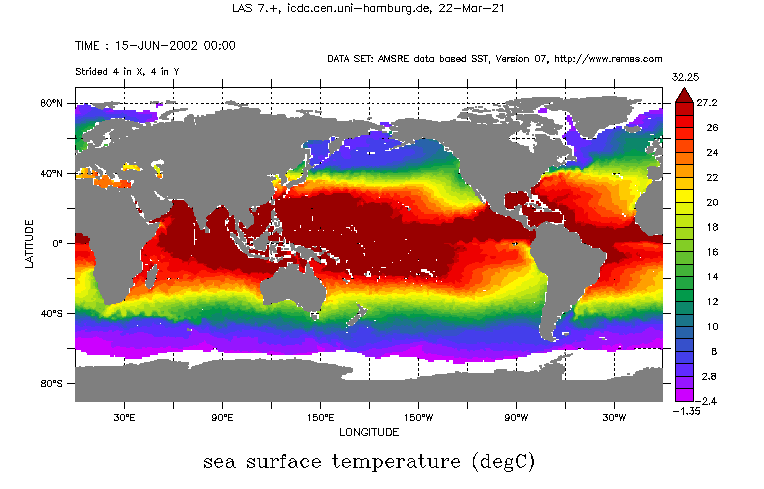
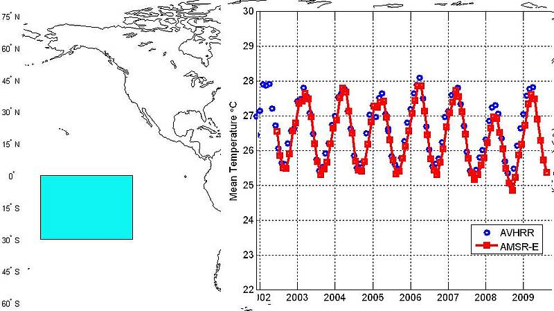
Sea surface temperature from AMSR-E

Topics
- Access
- Description
- Parameters
- Coverage, spatial and temporal resolution
- Data quality
- Contact person
- References
- Data citation and License
Access
RESTRICTED: This link to the data set is only available for a restricted user group. The data set is only accessible in CEN/MPI net or accessible from external nets with a customer account. Please contact ICDC if you would like to access this data from outside the network.
- View monthly means SST data at LAS (see menu in LAS for 3-day composites for each year)
- Access SST data via OPeNDAP
- Data access via file system: /data/icdc/ocean/amsre_sst
Description
Here we provide sea surface temperature (SST) data retrieved from observations of the satellite microwave radiometer Advanced Microwave Scanning Radiometer an Bord EOS (AMSR-E). This data is part of a "Multi-Parameter-Product", which is routinely produced at Remote Sensing Systems (see references) using AMSR-E brightness temperatures. The advantage of using microwave data instead of infrared data is, that the weather influence (emission and attenuation by water vapour and clouds) can be neglected, particularly for the low-frequency AMSR-E channels (6.9 GHz and 10.7 GHz). Note that due to the finite penetration depth of microwave radiation into the water column the observes SST represents the temperature of the uppermost millimeter

The AMSR-E sensor offers a complete daily data coverage at high latitudes while a mid- and low latitudes quite a number of data gaps occur. Therefore we offer here 3-day composites. This data is essentially free of data gaps. This data set is the final version (version 07) of this product.
Note that due to the large field-of-view which is associated with the used frequencies, a proper SST retrieval is not possible along coasts (even of small islands) and along the ice edge. Therefore no data is available for an approximately 75 km wide region adjacent to coasts and the ice edge.
ATTENTION: Recent results published by Gentemann, C. L., 2014 (see references) suggest a bias in the SST due to an incorrect application of a correction factor for low water vapour contents. This required bias correction is described in as well in Gentemann, C. L.. (2014).
Last update of data set at ICDC:
Parameters
| Name | Unit |
|---|---|
| SST (sea surface temperature) | °C |
| Data flag (information about missing data) | - |
Coverage, spatial and temporal resolution
Period and temporal resolution:
- June 1, 2002 to Oct. 04, 2011
- Daily as 3-day composite (file name corresponds to last day of 3-day interval used)
- June 2002 to September 2011
- Monthly
Coverage and spatial resolution:
- Global
- Spatial resolution: 0.25° x 0.25°, cartesian grid
- Geographic latitude: -89.875°N to 89.875°N
- Geographic longitude: 0.125°E to 359.875°N
- Dimension: 1440 columns x 720 rows
- Altitude: 0.0 m
Format:
- NetCDF
Data quality
This SST data has been compared to buoy observations, ship-based observations and the Reynolds SST. The data set does not include separate uncertainty estimates or quality flags; it contains however in a separate layer information regarding the reason for missing data (e.g. due to sea ice).
We suggest to take a look at the respective REMSS webpage and the other documents under references given below for more information.
Missing days:
- 2002-06-28,
- 2002-07-30 to 2002-08-07,
- 2002-09-13 to 2002-09-19,
- 2004-11-19,
- 2006-11-18,
- 2007-11-28,
- 2009-09-08,
- 2010-02-03,
- 2010-02-04
Contact
Stefan Kern
ICDC / CEN / University of Hamburg
E-Mail: stefan.kern"AT"uni-hamburg.deRemote Sensing Systems
email: support (at) remss.com
References
Literature:
- Dong, S., Gille, S. T., Sprintall, J., and Gentemann, C. (2006), Validation of the Advanced Microwave Scanning Radiometer for the Earth Observing System (AMSR‐E) sea surface temperature in the Southern Ocean, J. Geophys. Res., 111, C04002, doi:10.1029/2005JC002934. https://doi.org/10.1029/2005JC002934
- C. L. Gentemann, T. Meissner and F. J. Wentz, "Accuracy of Satellite Sea Surface Temperatures at 7 and 11 GHz," in IEEE Transactions on Geoscience and Remote Sensing, vol. 48, no. 3, pp. 1009-1018, March 2010, doi: 10.1109/TGRS.2009.2030322. https://ieeexplore.ieee.org/stamp/stamp.jsp?arnumber=5299116
- C. L., Gentemann (2014), Three way validation of MODIS and AMSR‐E sea surface temperatures, J. Geophys. Res. Oceans, 119, 2583– 2598, doi:10.1002/2013JC009716. https://doi.org/10.1002/2013JC009716
- AMSRE-ATBD Version 2, Nov 2000 (pdf, not barrier free)
- AMSRE-ATBD Version 2 Suppl, May 2007 (pdf, not barrier free)
Websites:
- Remote Sensing Systems, http://www.remss.com
- AMSR2 / AMSRE, Remote Sensing Systems, http://www.remss.com/missions/amsre
Data citation, License, and Acknowledgments
Please cite the data as follows:
AMSR-E data are produced by Remote Sensing Systems and sponsored by the NASA Earth Science MEaSUREs DISCOVER Project and the AMSR-E Science Team. Data are available at www.remss.com.
and with the following acknowledgments:
Distributed in netCDF format by the ICDC, CEN, University of Hamburg, Hamburg, Germany.
License
The data was published under the
