Surface Current Velocity OSCAR

Topics
- Access
- Description
- Parameters
- Coverage, spatial and temporal resolution
- Data quality
- Contact person
- References
- Data citation
Access
RESTRICTED: This link to the data set is only available for a restricted user group. The data set is only accessible in CEN/MPI net or accessible from external nets with a customer account. Please contact ICDC if you would like to access this data from outside the network.
- View velocity data at LAS
- Access data via OPeNDAP
- Data access via file system: /data/icdc/ocean/oscar_surface_current_velocity/
Description
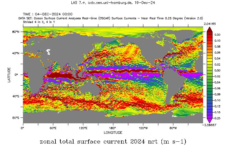
The subsequent data set, which is version V2.0, [obtained 2024-12-12] contains global near-surface current estimates, derived using quasi-linear and steady flow momentum equations. The horizontal velocity (zonal: u- and meridional: v-components) is a vertical average over a surface layer thickness of 30 m and is directly estimated from sea surface height, near surface vector wind and sea surface temperature data as described in brief in the Users Guide, see references.
The data used were collected from various satellites and in-situ instruments. These comprise
- gridded SSH anomalies (Sea Level SSH from C3S at ICDC)
- an absolute SSH product based on 7 years of GRACE mission data, altimetry and hydrologic and drifter data
- Near surface wind velocity (SSM/I until 07/1999, QuikSCAT (and presumably ASCAT) from 08/1999 until present
- Reynolds SST at weekly temporal resolution
The model formulation used combines geostrophic, Ekman and Stommel shear dynamics, and a complementary term from the surface buoyancy gradient [Bonjean and Lagerloef, 2002, references]. More details about the method are also given on the OSCAR webpage, see references.
Data files contain the u- and v-components of the surface current of the topmost 30 meters and the geostrophic current components. are given.
Last update of data set at ICDC: December 19 2024.
Parameters
| Name | Unit |
|---|---|
| Zonal surface velocity (u-component) | m/s |
| Meridional surface velocity (v-component) | m/s |
| Geostrophic zonal surface velocity (u-component) | m/s |
| Geostrophic meridional surface velocity (v-component) | m/s |
Coverage, spatial and temporal resolution
Period and temporal resolution:
- 1993-01-01 to 2024-12-04 (final product until 2022-08-04; NRT product 2022-01-01 onwards)
- daily
Coverage and spatial resolution:
- Global
- Spatial resolution: 0.25 degree x 0.25 degree; cartesian Grid
- Geographic latitude: -89.75°N to 89.75°N
- Geographic longitude: 0.25°E to 359.75°E
- Dimension: 1440 columns x 719 rows
- Altitude: -15.0 m
Format:
- NetCDF
Data quality
The data set does not contain estimates of the uncertainty.
The authors of the data set note that the gridded data sets used to generate the OSCAR products (see description) create errors in the product due to, e.g. clouds, high wind velocity and rain in case of the near surface wind velocity and SST, residual orbit errors and long wavelength errors in case of the SSH products, and formal mapping and sampling errors.
The OSCAR product accuracy and representativity is limited by the usage of a simplified diagnostic model of the surface circulation. Effects on the near surface currents due to local acceleration and non-linearities are not taken into account. This may limit the applicability of the OSCAR product to rather larger spatial scales (> 5° in longitude) and low frequency variations (> 20 days).
Information about validation and inter-comparison studies is given at the OSCAR webpage, and in various publications (see references).
Note: The FINAL and the NRT product are based on different sets of input data - namely a different atmospheric reanalysis and a different versions of the CMC SST product. It is hence not entirely clear how well FINAL and NRT ocean current data can be combined into one long time series. We recommend the user to carry out an intercomparison for both version using the period of overlap, which currently is 2022-01-01 through 2022-08-04.
Contact
Kathleen Dohan
Earth & Space Research (ESR), Seattle, WA
email: kdohan (at) esr.orgStefan Kern
University of Hamburg
email: stefan.kern (at) uni-hamburg.de
References
Literature:
- Users Guide for version V2.0 (pdf, not barrier free)
- Bonjean, F., and Lagerloef, G. S. E. (2002). Diagnostic Model and Analysis of the Surface Currents in the Tropical Pacific Ocean. Journal of Physical Oceanography 32, 10, 2938-2954, https://doi.org/10.1175/1520-0485(2002)032<2938:DMAAOT>2.0.CO;2
- Dohan, K., and N. Maximenko, 2010: Monitoring ocean currents with satellite sensors. Oceanography, 23(4), 94-103, doi:5670/oceanog.2010.08. https://doi.org/5670/oceanog.2010.08
- Dohan, K., 2017, Ocean surface currents from satellite data. J. Geophys. Res. - Oceans, 122, 2647-2651, doi:10.1002/2017JC012961. https://doi.org/10.1002/2017JC012961
Websites:
- https://www.esr.org/research/oscar/
- https://podaac.jpl.nasa.gov/dataset/OSCAR_L4_OC_FINAL_V2.0
- https://podaac.jpl.nasa.gov/dataset/OSCAR_L4_OC_NRT_V2.0
Data citation, License, and Acknowledgments
Please cite the data as follows:
Bonjean F. and G.S.E. Lagerloef, 2002: Diagnostic model and analysis of the surface currents in the tropical Pacific ocean, J. Phys. Oceanogr., 32, 2938-2954.
and
ESR; Dohan, Kathleen. 2022. Ocean Surface Current Analyses Real-time (OSCAR) Surface Currents - Near Real Time 0.25 Degree (Version 2.0). Ver. 2.0. PO.DAAC, CA, USA. Dataset accessed [YYYY-MM-DD] at https://doi.org/10.5067/OSCAR-25N20 [last access: December 19, 2024] for the NRT data set
or
ESR; Dohan, Kathleen. 2022. Ocean Surface Current Analyses Real-time (OSCAR) Surface Currents - Final 0.25 Degree (Version 2.0). Ver. 2.0. PO.DAAC, CA, USA. Dataset accessed [YYYY-MM-DD] at https://doi.org/10.5067/OSCAR-25F20 [last access: December 19, 2024] for the FINAL data set.
and with the following acknowledgments (data set has been rotated and flipped, CF compliance has been improved):
Thanks to ICDC, CEN, University of Hamburg for data support.
