Harmonized World Soil Database

Topics
- Access
- Description
- Parameters
- Coverage, spatial and temporal resolution
- Data quality
- Contact person
- References
- Data citation
Access
UNRESTRICTED:
- Get HWSD data from external sources: FAO Homepage | ISRIC Data Hub
- FAO License request: http://www.fao.org/contact-us/licence-request/en/
Description
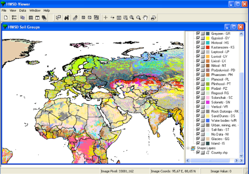
This soil type data set we are referring to here is based on the HWSD. "The Land Use Change and Agricultural Program" (LUC) of the "International Institute for Applied System Analysis" (IIASA) and the "Food and Agrigultural Organization of the United Nations" (FAO) have developed a new substantial "Harmonized World Soil Database" (HWSD). It refers to a 30 arc-sec raster database which presents the global soil classes and their occurrence and distribution on the earthʻs surface.
The project was carried out in partnership with:
- the "International Soil Reference and Information Centre" (ISRIC) and its "World Soil Information". Together with the FAO, they were responsible for the development of regional soil and terrain databases and the WISE soil profile database;
- the European Soil Bureau Network, which had recently completed a major update of soil information for Europe and northern Eurasia, and
- the Institute of Soil Science, Chinese Academy of Science, which provide the recent 1:1,000,000 scale Soil Map of China.
For version 1.0 of the HWSD, four source-databases have been used: The European Soil Database (ESDB), the 1:1,000,000 Soil Map of China, various regional SOTER Databases (SOTWIS Database) and the FAO-UNESCO Soil Map of the World.
The raster database contains more than 15000 different soil mapping units and combines existing regional and national updates of soil information worldwide (SOTER, ESD, Soil Map of China, WISE) with the information within the 1:5,000,000 scale FAO-UNESCO "Soil Map of the World" (FAO, 19711981).
The resulting database consists of 21600 rows and 43200 columns, which are linked to harmonized soil property data. This standardised texture allows the linkage of attribute data to the raster data to display or query certain soil units and their parameters.
The soil unit symbols refer to the "World Reference Base of Soil Resources" (WRB), the classification system that was developed in the context of the "Soil Map of the World".
Last update of data set at ICDC:
Parameters
We refer to the Harmonized World Soil Database (HWSD) website in the references for a list of parameters for example terrain, land-cover and soil quality .
Coverage, spatial and temporal resolution
Period and temporal resolution:
- Release 2009
- A suite of different maps and data sets
Coverage and spatial resolution:
- Global, only land, Antarctic excluded; regional maps and data sets also available
- Spatial resolution: 30'' x 30'', cartesian grid
- Geographic longitude: 180°W to 180°E
- Geographic latitude: 90°S to 90°N
- Dimension: 21600 rows x 43200 columns
- Altitude: following terrain
Format:
- RAR or ZIP archives
- JPG
Data quality
The reliabilty of the given information is variable. The areas covered by the SOTER database are the most reliable (Central and Southern Africa, Latin America, the Caribbean and Central and Eastern Europe), whereas data based on the FAO-UNESCO Soil Map of the World are considered less reliable (North America, Australia, West Africa and South Asia). The soils are classified according to the "World Reference Base for Soil Resources" (WRB). This worldwide reference base works as a global communication medium and was developed for the first FAO-UNESCO Soil Map of the World in 1988. Whilst it realised global communication a lot of details from regional classification systems were lost and a definite translation to, e.g. German soil denotations, is not possible.
Contact
Viale delle Terme di Caracalla
00153 Rome, Italy
Tel:(+39) 06 57051
email:FAO-HQ (at) fao.orgStefan Kern
ICDC / CEN / University of Hamburg
E-Mail: stefan.kern"AT"uni-hamburg.deRemon Sadikni
ICDC / CEN / University of Hamburg
E-Mail: remon.sadikni"AT"uni-hamburg.deAnnika Jahnke-Bornemann
ICDC / CEN / University of Hamburg
E-Mail: annika.jahnke-bornemann"AT"uni-hamburg.de
References
Literature:
- HWSD - Handbook: http://www.fao.org/fileadmin/templates/nr/documents/HWSD/HWSD_Documentation.pdf (pdf, not barrier-free)
- More Publications at FAO, http://www.fao.org/soils-portal/resources/en/
Websites:
- Harmonized World Soil Database (HWSD) v 1.2 at FAO Homepage, http://www.fao.org/soils-portal/soil-survey/soil-maps-and-databases/harmonized-world-soil-database-v12/en/
- International Soil Reference and Information Centre (ISRIC), World Soil Information, Data Hub, https://data.isric.org/geonetwork/srv/eng/catalog.search#/home
- Harmonized World Soil Database v 1.2, IIASA - Land Use Change and Agriculture Program, https://webarchive.iiasa.ac.at/Research/LUC/External-World-soil-database/HTML/
- Soil Maps and Databases, FAO SOILS PORTAL, Food and Agriculture Organization of the United Nations, Harmonized World Soil Database v1.2, Datenportal, http://www.fao.org/soils-portal/soil-survey/soil-maps-and-databases/en/
Data citation
Please cite the data as follows:
Fischer, G., F. Nachtergaele, S. Prieler, H.T. van Velthuizen, L. Verelst, D. Wiberg, 2008. Global Agro-ecological Zones Assessment for Agriculture (GAEZ 2008). IIASA, Laxenburg, Austria and FAO, Rome, Italy.
and with the following acknowledgments:
Thanks to ICDC, CEN, University of Hamburg for data support.
