Climatology of land surface temperature from MODIS
Topics
- Access
- Description
- Parameters
- Coverage, spatial and temporal resolution
- Data quality
- Contact person
- References
- Data citation
Access
UNRESTRICTED:
RESTRICTED: This link to the data set is only available for a restricted user group. The data set is only accessible in CEN/MPI net or accessible from external nets with a customer account. Please contact ICDC if you would like to access this data from outside the network.
- Data access via file system: /data/icdc/land/modis_lst_climatology
Description
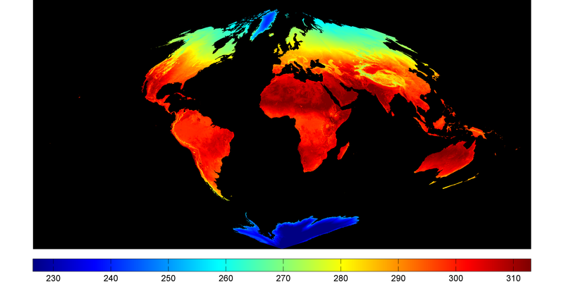
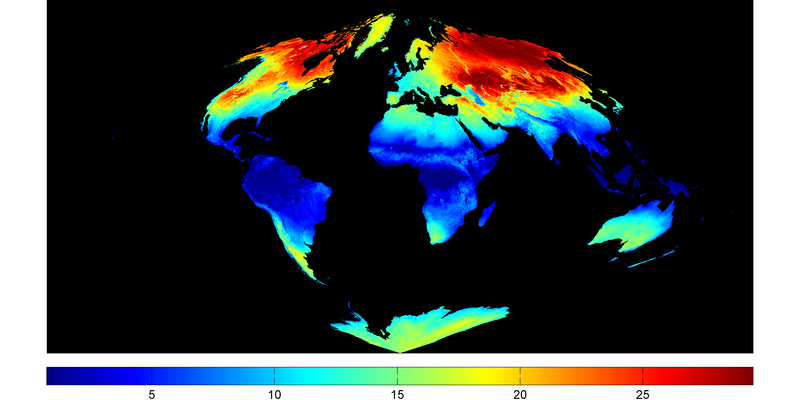
Here we offer a unique climatology of the land surface temperature derived from the annual cycle in MODIS land surface temperature (LST) data.
The main motivation for such a climatology is the fact that daily land surface temperature maps usually have plenty of gaps due to cloud coverage. The climatology provided here allows computing the climatologic mean land surface temperature for a particular day of the year without data gaps due to clouds for the entire globe.
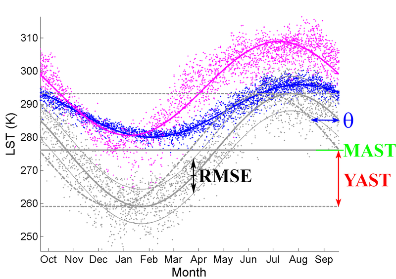
This is done with the following equation (1):
LST(day) = MAST + YAST * SIN(day * 2 pi/365 + Theta)
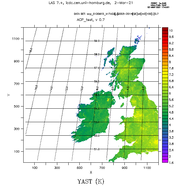
where LST is the land surface temperature to be retrieved for day day, MAST is the mean annual land surface temperature for 2003-2014, YAST is the mean annual amplitude of the land surface temperature for 2003-2014, and Theta is the phase shift in days relative to spring equinox on the northern hemisphere (see parameters). Note that day is counted relative to spring equinox on the northern hemisphere as well, e.g. March 31: day = 10.
The parameters were derived based on collection 005 of the MODIS daily level 3 global 1 km grid product from EOS Terra and Aqua (MOD11A1 and MYD11A1) - separately for night time and for day time.
For more information, please see the publication Bechtel et al 2015 about the climatology in the references.
This is version v0.7 of this product. This was created as a CliSAP/KlimaCampus Product.
Last update of data set at ICDC: February 12, 2016.
Parameters
| Name | Unit | Comment |
|---|---|---|
| Mean annual land surface temperature (MAST) | K | - |
| Mean annual amplitude of land surface temperature (YAST) | K | ≥ 0 |
| Phase shift relative to spring equinox on the NH (Theta) | days | -182.5 ... 0 ... 182.5 |
| Inter-diurnal and inter-annual variability (RMSE) | K | Root Mean Squared Error of fit |
| Number of clear-sky aquisitions (NCSA) | - | - |
Coverage, spatial and temporal resolution
Period and temporal resolution:
- Climatology, based on years 2003-2014
- Four maps per parameter (01:30 am, 10:30 am, 01:30 pm, 10:30 pm, all UTC)
- Daily resolution of "virtual LST" via application of equation (1)
Coverage and spatial resolution:
- Global
- Spatial resolution: 1km x 1km (MODIS Sinusoidal Grid)
- Geographic longitude: 180°W to 180°E
- Geographic latitude: 90°S to 90°N
- Dimension: 1200 columns x 1200 rows
- Altitude: following topography
- On 10° x 10° MODIS tiles, see MODIS tile distribution map
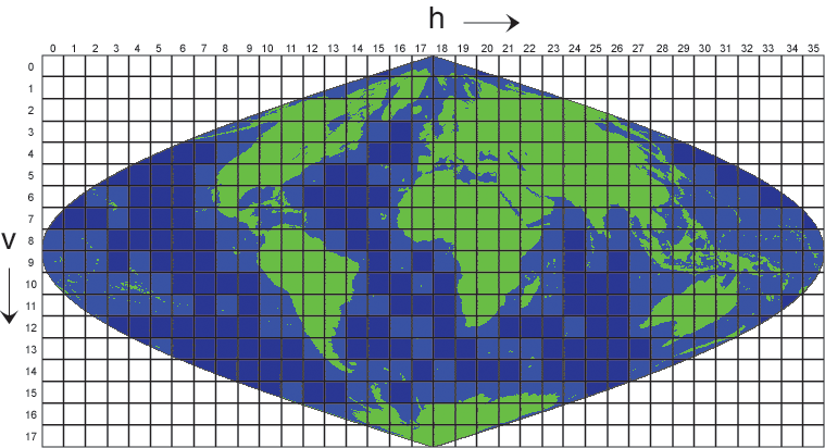
Format:
- NetCDF
Data quality
The climatology offered here has different levels of validity
- Land surface temperature retrieval from MODIS is only possible for clear-sky conditions. Since the parameters are derived from (mostly) cloud-free aquisitions they are under likewise conditions and their reliability is limited in areas of persistent cloud cover. Areas of intermittent clear-sky and cloudy phases can be expected to reveal a cold bias during nighttime and warm bias during (mostly) summer daytime compared to the real average conditions.
- The fitted annual cycle works best in areas poleward of the tropics of cancer and capricorn. Only there the seasonal change in land surface temperature is dominated by the seasonal cycle of solar irradiation which can be approximated by a sine function as is used in equation (1). Otherwise, at low latitudes the irradiation is characterized by several annual maxima. Further, dynamic processes like monsoon effects are more likely dominating the annual variation in land surface temperature which cannot be approximated well by a sine function.
- The RMSE can be regarded as a quality measure for the goodness of fit using equation (1) to compute land surface temperature distribution for an individual day. It can also be seen as a measure for the inter-diurnal and inter-annual variability of the land surface temperature.
- Our analysis of the MODIS MOD11A1 product revealed that the quality assessment (QA) flags were partly not reliable in urban areas. Hence the QA flags were not considered.
- Some tiles contain artifacts which might appear as lines or patterns. These originate from the original MODIS products (MOD11A1/MYD11A1), which apparently treat cloud-contaminated pixels differently dependent on their position.
Contact
Benjamin Bechtel
Institute of Geography / CEN / University of Hamburg
email: benjamin.bechtel (at) uni-hamburg.deStefan Kern
ICDC / CEN / University of Hamburg
E-Mail: stefan.kern@uni-hamburg.de<br />(stefan.kern"AT"uni-hamburg.de)
References
Literature:
- MODIS Land Surface Temperature Users' Guide (pdf, not barrier free)
- MODIS ATBD LST (pdf, not barrier free)
- Bechtel, B. A New Global Climatology of Annual Land Surface Temperature. Remote Sens. 2015, 7, 2850-2870. https://doi.org/10.3390/rs70302850
- Bechtel, B., Robustness of annual cycle parameters to characterize the urban thermal landscapes. IEEE Geosciences and Remote Sensing Letters, 9(5), 876-880, doi:10.1109/LGRS.2012.2185034. 2015. https://doi.org/10.1109/LGRS.2012.2185034
Data citation
Please cite the data as follows:
- Bechtel, B., A new global climatology of annual land surface temperature. Remote Sensing, 7, 2850-2870, doi:10.3390/rs70302850, 2015.
- Bechtel, B., Robustness of annual cycle parameters to characterize the urban thermal landscapes. IEEE Geosciences and Remote Sensing Letters, 9(5), 876-880, doi:10.1109/LGRS.2012.2185034. 2015.
and with the following:
Data of the Climatology of the MODIS land surface temperature version v0.7 were provided by ICDC, CEN, University of Hamburg.
