Vegetation Index NDVI from AVHRR GIMMS

Topics
- Access
- Description
- Parameters
- Coverage, spatial and temporal resolution
- Data quality
- Contact person
- References
- Data citation
Access
RESTRICTED: This link to the data set is only available for a restricted user group. The data set is only accessible in CEN/MPI net or accessible from external nets with a customer account. Please contact ICDC if you would like to access this data from outside the network.
- View NDVI data at LAS
- Access NDVI data via OPeNDAP
- Data access via file system: /data/icdc/land/gimms_ndvi
Description
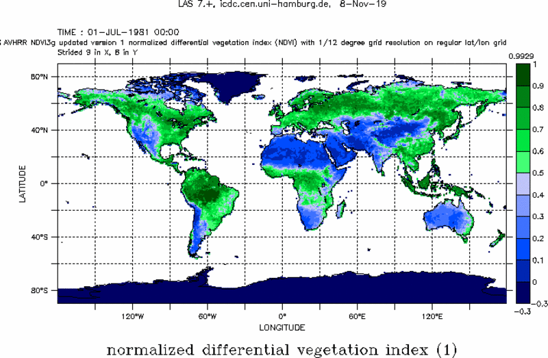
This data set comprises the Normalized Differential Vegetation Index (NDVI) together with some information about data quality, derived from reflectances observed by channels 1 and 2 of the Advanced Very High Resolution Radiometer (AVHRR) as part of the Global Inventory Modeling and Mapping Studies (GIMMS) project.
The NDVI is based on the difference: reflectance observed in the near-infrared (NIR) portion of the electromagnetic spectrum minus reflectance observed in the red portion of the electromagnetic spectrum. Areas with photosynthetically active vegetation absorb much more radiation in the red portion of the electromagnetic spectrum than areas without any or with photosynthetically inactive vegetation. This is due to the pigments in the leaves, needles, etc. In contrast, absorption of NIR radiation is low for both surface types. However, the amount of NIR radiation transmitted and/or scattered is a function of the surface type / roughness. Therefore, the difference of the reflectances is small for areas without any or with photosynthetically inactive vegetation and high for areas with photosynthetically active vegetation. Note that in areas with a lot of vegetation the dependence of the NIR-radiation scattering and/or transmission on the surface type / roughness helps to overcome saturation effects in the red portion of the electromagnetic spectrum and therefore allows a better separation of high NDVI values.
The impact of clouds, aerosols, sensor noise (and other error sources not mentioned here explicitly) is mitigated as are effects by changes in sensors, sensor degradation or changes in local sensor overpass time. For more details we refer to Tucker et al., 2005, and Pinzon and Tucker , 2014, in the references.
We offer the GIMMS NDVI3g version 1 data set with bi-weekly temporal resolution.
Last update of data set at ICDC: February 3, 2022
Parameters
| Name | Unit |
|---|---|
| NDVI | - |
| Quality flag, (Combination of retrieval flag and percentile) | - |
Coverage, spatial and temporal resolution
Period and temporal resolution:
- 1981-07-01 to 2015-12-31
- Bi-weekly (i.e. 2 times per month)
Coverage and spatial resolution:
- Global
- Spatial resolution: 1/12° x 1/12° (about 8 km, Climate Modeling Grid)
- Geographical longitude: 179.9583°W to 179.9583°E
- Geographical latitude: 89.9583°S to 89.9583°N
- Dimension: 2160 rows x 4320 columns
- Altitude: follows topography
Format:
- NetCDF
Data quality
This data set is based on re-calibrated AVHRR/2 and AVHRR/3 observations from aboard NOAA-7 to NOAA-19 satellites. This is version 1 of the NDVI3g data set, meaning that a number of improvements compared to version 0 has been made. (a) Reprocessed Level 2 entire SeaWIFS mission for the land products to reduce artifacts in the data, particularly changes in calibration after 2006 that generates drops in NDVI lower values [OB.DAAC / Ocean Biology Processing group NASA/GSFC 616 (April 2016)]. (b) Recovered negative NDVI values of snow-covered regions in winter in Northern latitudes. In Version0, we masked them with zero values, creating artifacts in phenology parameters; note that NDVI values for Greenland and Antarctica are deliberately set to -0.3. (c) Rescaled NDVI values and splitted the flag values from them.
The quality flag provided along with the data is a combination of information about the retrieval quality (good / from spline interpolation / from seasonal cycle) and of the percentile value of the given NDVI in the used time series; NDVI values are scaled according to the maximum NDVI found within the 15-day time series the data are representative for.
The data set does not include additional quality information. Due to the large number of different AVHRR sensors used and due to the fact that cloud masking is less reliable for AVHRR than for MODIS thanks to the limited number of channels, artifacts cannot be excluded (see for instance Krakauer et al. in the references).
Contact
Jorge E. Pinzon
Science Sytems and Applications Inc.
Biospheric Sciences Laboratory / NASA GSFC
E-Mail: jorge.e.pinzon (at) nasa.govCompton J. Tucker
Earth Science Division
NASA GSFC
E-Mail: compton.j.tucker (at) nasa.govStefan Kern
ICDC / CEN / University of Hamburg
email: stefan.kern (at) uni-hamburg.de
References
Literature:
- Compton J. Tucker, Jorge E. Pinzon, Molly E. Brown, Daniel A. Slayback, Edwin W. Pak, Robert Mahoney, Eric F. Vermote & Nazmi El Saleous (2005) An extended AVHRR 8‐km NDVI dataset compatible with MODIS and SPOT vegetation NDVI data, International Journal of Remote Sensing, 26:20, 4485-4498, DOI: 10.1080/01431160500168686, https://doi.org/10.1080/01431160500168686
- Pinzon, J.E.; Tucker, C.J. A Non-Stationary 1981–2012 AVHRR NDVI3g Time Series. Remote Sens. 2014, 6, 6929-6960. https://doi.org/10.3390/rs6086929
- Pinzon, J. E.: A Non-Stationary 1981-2015 AVHRR NDVI3g Time Series. American Geophysical Union, Fall Meeting 2015, abstract id. GC34C-08, 2015.
- Kern, A., Marjanovic, H., and Barcza, Z.: Evaluation of the quality of the NDVI3g dataset against collection 6 MODIS NDVI in central Europe between 2000 and 2013. Remote Sensing, 8(11), 955, 2016, https://doi.org/10.3390/rs8110955
- Krakauer, N.Y.; Lakhankar, T.; Anadón, J.D. Mapping and Attributing Normalized Difference Vegetation Index Trends for Nepal. Remote Sens. 2017, 9, 986. https://doi.org/10.3390/rs9100986
Websites:
- NDVI: Normalized Difference Vegetation Index-3rd generation: NASA/GFSC GIMMS | NCAR - Climate Data Guide, https://climatedataguide.ucar.edu/climate-data/ndvi-normalized-difference-vegetation-index-3rd-generation-nasagfsc-gimms
Data citation
Please cite the data as follows:
Pinzon, J.E. and Tucker, C.J.: A Non-Stationary 1981-2012 AVHRR NDVI3g Time Series. Remote Sensing, 6(8), 6929-6960, doi: 10.3390/rs6086929, 2014
National Center for Atmospheric Research Staff (Eds). Last modified 14 Mar 2018. "The Climate Data Guide: NDVI: Normalized Difference Vegetation Index-3rd generation: NASA/GFSC GIMMS." Downloaded from https://climatedataguide.ucar.edu/climate-data/ndvi-normalized-difference-vegetation-index-3rd-generation-nasagfsc-gimms [last accessed: November 7 2019] and provided by Integrated Climate Data Center (ICDC, https://www.cen.uni-hamburg.de/icdc ) [date].
