World Ocean Hydrographic Profiles (WOHP)

Topics
- Access
- Description
- Parameters
- Coverage, spatial and temporal resolution
- Data quality
- Contact person
- References
- Data citation and License
Access
UNRESTRICTED:
RESTRICTED: This link to the data set is only available for a restricted user group. The data set is only accessible in CEN/MPI net or accessible from external nets with a customer account. Please contact ICDC if you would like to access this data from outside the network.
- Data access via file system: /data/icdc/ocean/historical_hydrographic_data/DATA/wohp
Description
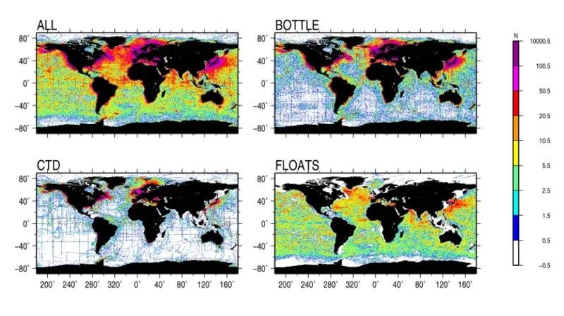
The data-product consists of 4,081,174 temerature and salinity profiles, which were obtained by means of the bottle (Nansen) casts, CTD (Conductivity-Temperature-Depth profilers) and autonomous profiling floats. The World Ocean Database WOD2009 (update as of December 2010) (Boyer et al., 2009) served as a data basis. The first version of the data-product includes quality checked data at observed levels. Each T/S-profile can be identified via a unique ID number. For each profile the information on the ocean bottom depth is provided. The depths were taken from the high-resolution digital ocean bottom bathymetry (GEBCO). The data product is subdivided into 338 data files written in ASCII format. Each data file corresponds to a 0.5-degree geographical zone. The data can be read in using the FORTRAN program read_hydrodat.f (see references). These data were produced as ICDC project. Version is V1.0.
Last update of data set at ICDC:
Parameters
| Name | Unit |
|---|---|
| Depth | m |
| Temperature | °C |
| Salinity | - |
Coverage, spatial and temporal resolution
Period and temporal resolution:
- 1804 to 2010
- Various temporal resolution, different number of profiles of different length obtained during various measurement campaigns
Coverage and spatial resolution:
- Global (see figure on top of page)
- Spatial resolution: None, sampling along the cruise tracks depends on measurement campaign
- Geographic Latitude: -90°N to 90°N
- Geographic Longitude: 0°E to 360°E
- Dimension: 1 column x 1 row x N measurements along the vertical profile
- Altitude: N depths, vertical profiles
Format:
- ASCII
- Data are organized in 0.5° x 0.5° grid boxes
Data quality
The quality of the original data was assessed using several quality checks. First, the crude error check was conducted flagging the data which are grossly in error. To identify crude errors each observation was compared with the respective parameter range specified for several ocean areas. During the next check the hydrostatic stability of the density profile and the values of the vertical T/S-gradients were checked. Finally, each observed value was compared with the mean for all data in a certain vicinity around the profile, and the difference between the observation and the mean value (measured in standard deviations) was calculated.
A detailed description of the data product is in preparation.
Contact
Stefan Kern
ICDC / CEN / University of Hamburg
E-Mail: stefan.kern"AT"uni-hamburg.deRemon Sadikni
ICDC / CEN / University of Hamburg
E-Mail: remon.sadikni"AT"uni-hamburg.deAnnika Jahnke-Bornemann
ICDC / CEN / University of Hamburg
E-Mail: annika.jahnke-bornemann"AT"uni-hamburg.de
References
Literature:
- FORTRAN program read_hydrodat.f
- Boyer, T.P., J.I. Antonov , O.K. Baranova, H.E. Garcia, D.R. Johnson, R.A. Locarnini, A.V. Mishonov, T. D. O’Brien, D. Seidov, I.V. Smolyar, M.M. Zweng, 2009. World Ocean Database 2009 S. Levitus, Ed., NOAA Atlas NESDIS 66, 216 pp. https://repository.library.noaa.gov/view/noaa/1195
Data citation, License, and Acknowledgments
Please cite the data as follows:
V. Gouretski: WOHP (World Ocean Hydrographic Profiles) V1.0, 2010, ICDC, CEN, University of Hamburg, Hamburg, Germany.
and with the following acknowledgments:
Thanks to ICDC, CEN, University of Hamburg for data support.
License
The data was published under the Creative Commons Attribution 4.0 International License (CC-BY-4.0).
