Witnesses of the wind: what the grains of sand in a dune can tell usGeologist Sebastian Lindhorst used the sand deposits in a wandering dune on Sylt to reconstruct how hard the wind blew in the past. Where no recordings are available this climate archive can provide reliable information.
21 February 2017, by Franziska Neigenfind

Photo: UHH/CEN/S. Lindhorst
They were shaped by the whims of nature: the municipality of List on the North Sea island Sylt is home to 30-meter-tall wandering dunes. Exploring the dunes can not only
They were shaped by the whims of nature: the municipality of List on the North Sea island Sylt is home to 30-meter-tall wandering dunes. Exploring the dunes can not only allow them to tell us the story of their formation, but also how strong the winds that formed them were in the past. Similar to tree rings, the internal layers of dunes provide a record of the past. To decipher this valuable climate archive, my team I investigated the makeup of a wandering dune on the island’s northern shore.
Aerial photographs from 1936 to 2009 reveal how the winds shifted the dunes farther east, year after year. Depending on their intensity, they moved the dunes only three meters in one year, but as much as seven meters in another. But how do dunes store the information on how strong or weak the winds were?
The measurements we take with ground-penetrating radar offer valuable data, and a cross-section of the dune – which allows us to see how the wind pushed on the grains of sand, forcing them to accumulate layer by layer. The architecture of dunes is highly complex and includes many irregularities. Nevertheless the data shows us that weaker winds only transport the finer grains of sand, whereas stronger winds spark a cascade effect, setting grains of all size in motion. As such, deposits that primarily consist of smaller grains indicate weaker winds, and those with a broad range of grain sizes were deposited under stormy conditions. Once a dune’s crest reaches a critical angle, the sand on the leeward side tumbles down in a landslide. This layer always falls to the east – due to the prevailing westerly winds on our North Sea coast.
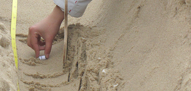
To determine how the different sizes of sand particles are distributed in the dune, we took nearly 5,000 samples. This was only possible in the winter; since the sand was frozen and the layers were temporarily preserved, there was no danger of the wind ruining our samples. Using picks and shovels, we dug a 245-meter-long trench in the direction of the dune’s “wandering” and gathered thimblefuls of sand from the trench bottom – one every five centimeters.
We then brought the samples back to the lab, where we used a specially designed laser measuring device to gauge the spectrum of different grain sizes. Particles with different sizes refract the laser beam to different extents. The resulting pattern offers insights into the grain-size distribution in the respective sample, and the mean value of the size distribution ultimately provides us with an image of the wind intensity at the time when the sand grains from the sample were deposited.
But how representative are the results? To find out, we compared them with the recordings taken by a nearby weather station that has recorded wind data since 1950. And voila: the annual wind intensities from the two datasets match. For example, both show a marked increase in wind speed during the 1960s. Further, our reconstruction indicated that the early 20th century must have been very stormy – just as the recordings taken at the time confirm.
That shows us our method works quite well – which means, in cases where no recordings are available, our “dune archive” can provide reliable information on past wind intensities. In turn, that information can be used to verify the accuracy of climate simulations and help improve prognoses of future developments in wind and storm activity.
This content was first published as a guest article in the newspaper Hamburger Abendblatt on February 13, 2017.
