Detective work in the marshes
18 June 2019, by Stephanie Janssen

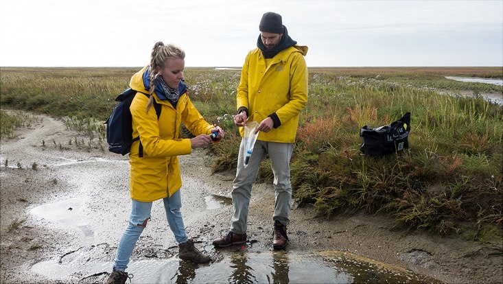
Photo: UHH-CEN-Y.Milker
Salt marshes along the German North Sea coast are a world of their own: these “salty meadows” form an important transitional zone between the ocean and the land, which helps to protect the hinterland from major storm surges. But what will happen if the sea level rises? Doctoral candidate Dorothea Bunzel is investigating sediment cores to unravel the past development of the salt marshes, and their ability to adapt to changing climate conditions.
Dorothea Bunzel, you drilled sediment cores from the salt-marsh areas in the Bay of Tümlau, near Westerhever. Can you tell me what it was like?
Difficult, because the marshes are protected conservation areas since 1985, and were declared as UNESCO World Heritage Site in 2009. In terms of fieldwork, that means there are a number of restrictions. For instance, we can only work in the marshes in the autumn and spring, and only during low tide, so as not to disturb any wild or migratory birds.
On site, we started digging a hole and thus excavated a vertical section of roughly 1.2 meter depths below the marsh surface. We then pressed long, U-shaped plastic channels into the previously exposed and cleaned cliff face. So as to carefully separate the U-channels together with the recovered sediment from the surrounding soil, we then pulled a length of fishing line from behind and along the open side of the “U.” This method allows us to avoid mechanical compression of the single sediment layers and skewing the results, which can easily happen with traditional core-drilling methods. That being said, we always have to hurry with this method, because, as the tide rises, the hole we excavated begins to fill with water.

Why do you need sediment cores?
Thanks to the sequence of sediments inside each one, the cores offer us a timeline of sorts. In the Bay of Tümlau, the sediments at one meter depths are roughly 100 years old, and of course grow younger and younger, the closer we get to the sediment surface. We retrieved the cores at a location that has consistently been above the intertidal zone for the past several centuries, which means the marshes there are only covered with water in the event of a storm surge. When that happens, sediments are deposited on top of the marshes, which then gradually continue to grow. In this way, the marshes represent an important buffer zone at the seaside of the dikes, which can help to slow down the waves produced by storm surges.
But if climate change produces rising sea levels, the annual storm surges will also become much more frequent, at least according to prevailing climate simulations. Does that mean local dikes need to be raised? To answer that question, we need data of past storm surges, so that we can compare them and estimate what could happen in the future.
And what can you derive from sand and mud?
First of all, I investigate at what a specific layer of sediment consists of, and what that tells me about the climatic conditions at the time of its deposition. To do so, I determine tiny, single-celled organisms that can be found all over in the sediment. Technically known as foraminifera, they build an external test, either from calcium carbonate or from sand grains glued together by an organic cement. As a result, they can still be found today as fossils.
Different species of foraminifera have adapted to highly diverse marine habitats. Some like water with high salinity, some prefer the constantly changing intertidal zone, and still others seek a virtually dry setting. Therefore, depending on which species I find, I can reliably say, for instance, that a given sediment lay could only have been deposited by a storm surge, since the specific foraminifera inside only appear offshore. In this way, I analyze every centimeter of the sediment core, bit by bit.

And how do you know when certain events took place?
It’s tricky. Since the intertidal areas are highly dynamic habitats, the layers aren’t deposited uniformly, and the time segments can have a broad range of thicknesses. As a result, I had to invest several months’ worth of detective work. For instance, laboratory measurements can tell us how much cesium a sample contains. Since cesium does not occur naturally, the cesium mainly originates from the nuclear bomb testing in 1962/63, or from the Chernobyl nuclear power plant accident in 1986. If I find two sections with high cesium concentrations in the same core, it provides me with two valuable time references. The mercury concentration also offers useful clues: during the Second World War, the concentration was high because it was used in detonators for military bombs, and the concentration rose again in the 1960s and 1970s thanks to industrialization. So I combined a number of different methods to gradually narrow down which time segments we were dealing with.
How will climate change affect the salt marshes?
In this region, the projected sea-level rise is 2.4 millimeters per year. Right now, the marsh surfaces are located roughly 50 centimeters above the intertidal zone. According to our calculations, during the past decades they’ve been growing at a rate of eleven millimeters per year; that’s enough for them to keep pace with the expected sea-level rise.
Publication
Müller-Navarra K, Milker Y, Bunzel D, Lindhorst S,Friedrich J, Arz H, Schmiedl G (2019): Evolution of a salt marsh in the southeastern North Sea region – Anthropogenic and natural forcing; Estuarine, Coastal and Shelf Science, 218 (p 268-277)
Contact: Dorothea Bunzel, Center for Earth System Research and Sustainability (CEN), Universität Hamburg, dorothea.bunzel"AT"uni-hamburg.de


