Using Wotan’s help to see how the wind blows
3 April 2019, by Kerstin Schäfer, CEN

Photo: privat
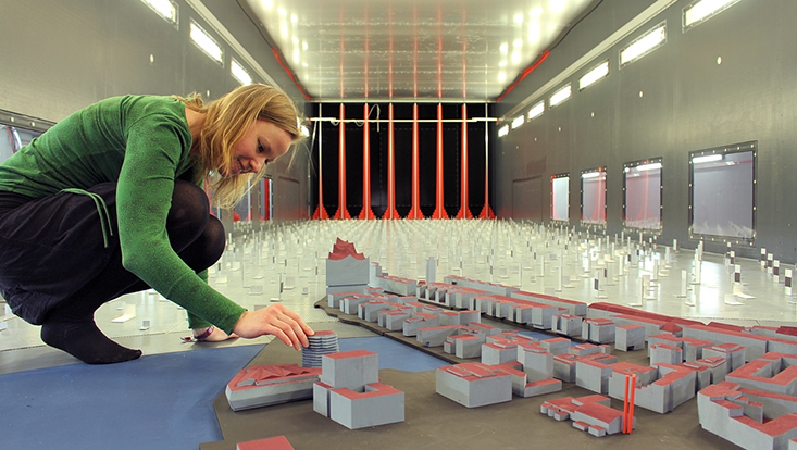
Sawing, gluing, and hunting down data: it took months before my miniature version of Hamburg was ready. First I had to find out what each and every building between the Elbphilharmonie concert hall and the Großmarkt (wholesale market) looked like – how tall it was, what its roof was shaped like, and whether it had any passages or overhangs. I requested blueprints from the city authorities and, in many cases, scouted out the locations on foot. Once I’d gathered all the information I needed, I prepared detailed technical drawings, which I then sent to one of the precision engineering workshops at Universität Hamburg. Once their work was done, I glued the hundreds of tiny model buildings onto sheets of wood. At a scale of 1 to 500, three-story houses were only 2.1 centimeters tall, and the Elbphilharmonie was 22 centimeters. Then the moment finally arrived: I was ready to throw the switch on “Wotan.”

Once I did, I could use the boundary-layer wind tunnel to observe how air currents flow through backyards and the alleys between houses, how pollutants spread, and how individual buildings slow the wind: important information for planners whose job it is to make cities ready for the future. Metropolises will be especially hard-hit by the emerging climate change; for example, when increasingly frequent heat waves transform them into sweltering ovens that barely cool down overnight. To help ensure that city dwellers can nevertheless breathe freely and stay healthy, my colleagues at the Center for Earth System Research and Sustainability (CEN) and I have joined in a countrywide research project on urban climate. After all, around the globe – and in Germany – half the populace now lives in cities.
The project’s goal is to develop a software program that can calculate how the wind blows in a given city, and how great its cooling effect is – before the city, subdivision or building in question is ever built. To make the software as accurate as possible, the developers compare the outputs with actual readings. Though these real-world measurements reflect the reality, they can also be confusing, because there is a virtually endless number of factors to take into account: shifts in wind direction; air currents produced by warming as the day progresses; vehicles that create their own air currents, etc. In contrast, the wind tunnel allows me to gather data that solely represents the influence of wind.
In addition to Hamburg, I’ve also made models of other major urban areas as “reference cities” and found that the air circulation in them differs considerably. Whereas, in Hamburg, the wind can blow in from across the expansive, open waters into the city’s core, in Stuttgart the air often becomes trapped between the surrounding hills. And in Berlin, the sheer distance makes it difficult for air to travel from the suburbs to the center.
In terms of modeling the cities, there were various aspects that I had to bear in mind: the surfaces of the tiny buildings couldn’t be too coarse or too smooth; otherwise it could have skewed the outcomes. Here, I found the ideal material to be Styrodur: a type of polystyrene used for insulating buildings, it is sturdier and has finer pores than Styrofoam. Instead of blowing air into the wind tunnel, we suck it in, so that we can see how the current first hits obstacles before it reaches the city’s core; this approach ensures that it circulates realistically.
With regard to ventilation for their centers, none of the three cities is ideally designed. And that’s no surprise: they’ve all grown over time, and were first founded in an age in which no-one could have guessed that the temperatures would someday rise so dramatically. Just how hot it’s going to get is something we can’t yet say exactly. But one thing is clear: we need to be prepared, which we can do by planning cities so that they have sufficient ventilation.
Kerstin Schäfer is a doctoral researcher at Universität Hamburg’s Meteorological Institute and a member of the Center for Earth System Research and Sustainability (CEN).
This article was first published as a guest article in the Hamburger Abendblatt as part of a monthly series on climate research. Here you can find more articles of the series.


