Manfred Wendisch from the Institute for Meteorology at Leipzig University is the scientific coordinator of the five-week HALO-(AC)3 measuring campaign, which will study changes in air masses on their way into and out of the Arctic. What exactly happens to these air masses, particularly with regard to cloud formation, will be observed in detail using state-of-the art instruments. These changes to air masses cannot be characterized by local, ground-based instruments, as there are only a limited number of meteorological measurement stations in the central Arctic region. For this reason, three measurement aircraft will be applied as part of HALO-(AC)3 to observe the changes of the air masses on their way into and out of the Arctic. The researchers aim to determine changes to the air masses using a quasi-Lagrangian observation method. In this technique, each flight pattern is adapted to the direction of movement of the relevant air mass, allowing changes to clouds, humidity, temperature and many other parameters to be measured directly. The data obtained in this way will be used to assess the accuracy of numerical weather forecasting models, which are necessary for predicting the future changes of the Arctic climate. Thus, the campaign will help to close an important gap in climate research knowledge, which was identified by the Intergovernmental Panel on Climate Change (IPCC) in the second part of its latest assessment report.
Manfred Wendisch summarises the goal of HALO-(AC)3 as follows: “Predicting the future of the Arctic climate remains a challenge. We want to carry out an extensive flight campaign – HALO-(AC)3 – that uses innovative observation methods to help reduce major uncertainties in the projection of future climate development in the Arctic.”
Coordinated measuring flights with three research aircraft
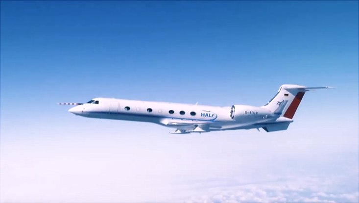
Three German research aircraft will be used to perform measurements for HALO-(AC)3. The first is HALO (High-Altitude and Long-Range Research Aircraft), a modern research aircraft operated by the German Aerospace Center (Deutsches Zentrum für Luft- und Raumfahrt; DLR). “HALO will operate at higher altitudes as a remote sensing platform, as it is capable of covering distances of up to 10,000 kilometres at altitudes of up to 15 kilometres,” explains Andreas Minikin of the DLR Flight Experiments facility. Meanwhile, in tandem with HALO, the Polar 5 and Polar 6 aircraft will conduct detailed measurements of the air masses at lower altitudes. The two polar aircraft have been used in the Arctic for more than 10 years under the direction of the Alfred Wegener Institute, Helmholtz Centre for Polar and Marine Research (AWI). Covering distances of between 1500 and 2000 kilometres, they will complement HALO by conducting measurements at altitude ranges below six kilometres. Andreas Herber, an AWI researcher and the coordinator for Polar 5 and Polar 6, adds: “Although the polar aircraft have a shorter range, they have the major advantage of being able to fly ‘low and slow’, so they can capture snapshots of very specific processes taking place in, below and above clouds, and in the planetary boundary layer.”
The aircraft are equipped with state-of-the-art instrumentation that can survey the entire atmosphere from the ground up to an altitude of 10 kilometres. The most important measurement parameters include cloud properties, temperature and humidity profiles, energy fluxes and the properties of aerosol particles and trace gases. Susanne Crewell, an atmospheric researcher at the University of Cologne, explains: “By coordinating the flight patterns of the three aircraft, we can track the air masses as they evolve in space and time. These measurements make it possible to take a closer look at the smallest cloud structures, all the way down to individual cloud particles, and to investigate the effect of Arctic sea ice on cloud properties. By combining various measurements we will be able to obtain an almost complete picture of the air masses under investigation.” Important tools for this are what are referred to as ‘dropsondes’, which are released from the aircraft and descend to the ground on small parachutes. As they descend through the atmosphere, they acquire measurements of temperature, air pressure and humidity.
In parallel with the aircraft measurements, the Leibniz Institute for Tropospheric Research (TROPOS) and the Leipzig University will conduct profile measurements using a tethered balloon at the AWI-research station AWIPEV near Ny-Ålesund on Svalbard. In addition to meteorological measurements, small-scale exchange processes, radiation and aerosol parameters will also be examined from the ground up to a height of one kilometre. A first set of these measurements were collected in autumn 2021 during the transition to the polar night and will now be repeated at the transition to the polar day, to link ongoing ground measurements with aircraft measurements. The extensive data set acquired by the HALO-(AC)3 campaign will be enhanced by measurements from ground-based remote sensing instruments at the AWIPEV research station, together with the latest satellite remote sensing methods and state-of-the-art numerical climate models.


