CEN - Center for Earth System Research and Sustainability
Centerfor Earth System Research and Sustainability (CEN)
Photo: UHH/Denstorf
29 November 2016, by Dr. Heike Konow
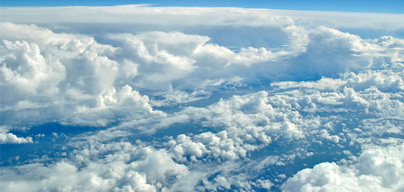
Photo:
News from Climate Science: Once a month, climate researchers report on their latest findings in the newspaper “Hamburger Abendblatt”. Heike Konow is a meteorologist
Just ahead of us, a major cyclone is brewing. We’re not going to pass up the opportunity to explore a hurricane at close range. I check the measuring equipment one more time, as the engines of our HALO research plane drone incessantly. Off the coast of the Caribbean island Barbados, we hope to learn more about clouds and circulations, the term meteorologists use to describe cyclical air currents.
Clouds present climate researchers with a mystery. We still can’t say for certain whether they intensify or mitigate climate change. Even if we disregard climate change, the effects of clouds are confusing: high-altitude ice-crystal clouds, referred to as cirrus clouds, protect the Earth and prevent its surface from overheating, while lower-altitude clouds help to insulate the ground, sealing warmth in overnight. To more accurately estimate how clouds affect climate models, we need to know exactly how many clouds are in the sky, how large they are, their altitude, and their composition.
That’s why we want to use the HALO to fly above the uppermost cloud layer. It’s harder to observe clouds over the ocean than over the mainland, since there is no network of ground stations that constantly puts out new data. Just like ground stations and satellites do, on board the HALO we use remote sensing instruments. Our cloud radar, which can identify large water particles but not ice crystals, measures clouds’ position and form. A microwave radiometer provides data on a given cloud’s interior and lets us know how water and ice are distributed within it. Lastly, a lidar system generates laser beams and measures the moisture profile surrounding the cloud in question. The lidar can also recognize sheets of ice, but is blind as a bat when it comes to measuring what’s below them. As such, using mixed methods is essential: only the combination allows us to measure the cloud as a whole.
My job is to prepare the measuring equipment and monitor it during the flight. The system takes a new measurement every second. Since clouds are normally one to three kilometers wide and we sweep over them at roughly 800 kilometers per hour, we only have time for a few snapshots per cloud; nevertheless, in the end they provide us with a good cloud profile of our flight. In the course of the eight- to ten-hour flight we also deploy up to 50 dropsondes, which we drop out a special chute. The probes, which only weigh a few hundred grams each, float down on a mini-parachute and transmit additional data on air pressure, temperature and humidity. Once we’re back in Hamburg, I analyze hundreds of cloud profiles and compare them with satellite data and weather models. These models are based on physical assumptions and produce computer simulations of cloud patterns.
Our HALO data shows that the clouds in the model are generally too high. Further, the model predicted more clouds than we actually found. These discrepancies offer valuable insights, allowing us to constantly improve hurricane and weather forecasts. At the same time, the data provides important components for making future climate scenarios even more accurate.