+++Joint press release of Universität Hamburg and the Alfred Wegener Institute+++Success in the Arctic: Research team accurately measures the “thin” ice
14 April 2014, by Markus Dressel

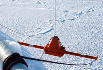
Photo: M. Schiller/AWI
A team of scientists recently spent two weeks on board the “RV Lance” a research ship chartered by Universität Hamburg. They were...
A team of scientists recently spent two weeks on board the “RV Lance” a research ship chartered by Universität Hamburg. They were accompanied in their work by the Alfred Wegener Institute’s research plane Polar 5 and numerous helicopter flights. And their efforts paid off: an intelligent combination of satellite data, ice radar and computational models provides the basis for measuring the thinning sea ice, and for safely navigating in the Arctic.
Though it sounds paradoxical, in the Arctic it’s the thin ice that is most dangerous for ships. “Wind and ocean currents tend to stack up the comparatively thin sea ice,” explains Prof. Lars Kaleschke from Universität Hamburg’s Center for Earth System Research and Sustainability. “One minute a ship can be making good headway, then suddenly high ridges of pack ice form, surrounding the vessel and its crew.” At the same time, it’s difficult to precisely measure sea ice; satellites can help, but only work if the ice is at least a meter deep. “But the seasonal ice, which completely reforms every year and is now undergoing major transformations thanks to climate change, is usually not thick enough,” claims Kaleschke. “Global warming is not only affecting the area covered by ice, but also the ice thickness. Thin ice is the ice of the future.”
Kaleschke and his colleagues from the Alfred Wegener Institute, Helmholtz Center for Polar and Marine Research (AWI) are now the first to successfully measure ice thicknesses of less than a meter, a task they accomplished with the help of the European Space Agency’s (ESA) SMOS satellite. Just how precise their new method is could be seen in measurements that were analyzed on board the “Lance”: throughout the voyage, electromagnetic waves were used to measure the ice packs the ship passed through, and the results were compared with data from the SMOS data. At the same time, the ship’s onboard helicopter took to the air, taking readings with a suspended electromagnetic sensor. And, at a much higher altitude and speed, the research plane Polar 5 expanded the measuring area.
Dr. Stefan Hendricks, a sea ice physicist at the AWI, investigated the thin, one-year-old ice together with colleagues from the European Space Agency (ESA) and Technical University of Denmark (DTU). To do so they used EMIRAD, a measuring device based on the same principles as the SMOS, but capable of delivering more detailed images of thin ice than the satellite. These readings were also supported by a new type of radar that can measure the thickness of snow above the ice. Two of the flights combined the helicopter and plane, while a third was directly under the flight path of the satellite Cryosat-2. “When it comes to analyzing the results, the focus is on comparing the data from the Cryosat-2 and SMOS satellites, and on combining them wherever possible – which should provide us with even better ice observations from space,” states Hendricks.
Further, for the length of the expedition the “Lance” navigated with the help of a new ice prediction system designed to ensure ships’ safe passage through polar regions in the future. The system is based on a computational model developed at Universität Hamburg, which researchers use to provide information on the expansion, thickness and movement of the ice. The results are sent twice a day to the Hamburg Ship Model Basin (HSVA), which in turn transmits them to ships underway in the Arctic – together with individual route recommendations. “The whole thing works like a type of traffic-jam warning system,” reports Dipl.-Ing. Peter Jochmann of the HSVA. “The only difference is that here we’re not talking about traffic density, but about when and at what speed the ship will reach the edge of the ice, how thick the floes will be and which alternate routes would be an option.”
In this aspect, too, the voyage proved to be a successful practice test: not only did the prediction system safely guide the ship through the difficult region; the suggested routes ultimately turned out to be consistently faster than the originally plotted course. The only time the “Lance” ran into trouble was when – ignoring the route suggested by the system – it tried to return to its home port by taking a direct (and therefore presumably faster) course. After just a few kilometers, the ship was forced to turn back.
In addition to the Hamburg Ship Model Basin, which coordinated the joint project, the following partners participated in the IRO2 (Ice-Routing Optimization) and SMOS ICE projects: Universität Hamburg; University of Bremen; Alfred Wegener Institute, Helmholtz Center for Polar and Marine Research; Ocean Atmosphere Systems GmbH; FastOpt GmbH; National Space Institute, Technical University of Denmark; Norwegian Polar Institute; Federal Maritime and Hydrographic Agency; Joachim Schwarz Consulting; and European Space Agency (ESA). IRO-2 received funding from the Federal Ministry for Economic Affairs and Energy. SMOS ICE was financed by the European Space Agency, the helicopter flights by the Norwegian Polar Institute, and the ice-drift buoys by the German Research Foundation (DFG).
Image gallery:
Impressions of the joint campaign
Further information:
Safe Passage for Shipping: Researchers Test Forecasts for Arctic Sea Ice
Meteorologisches Institut: IRO-2
Hamburgische Schiffbau-Versuchsanstalt (HSVA)
Contact:
Prof. Dr. Lars Kaleschke, Institut für Meereskunde, Centrum für Erdsystemforschung und Nachhaltigkeit der Universität Hamburg, Tel: 040 42838 6518, lars.kaleschke"AT"zmaw.de
Ute Kreis, Presse- und Öffentlichkeitsarbeit, Centrum für Erdsystemforschung und Nachhaltigkeit der Universität Hamburg, Tel: 040 42838 4523, ute.kreis"AT"zmaw.de
Dr. Stefan Hendricks, Alfred-Wegener-Institut Helmholtz-Zentrum für Polar- und Meeresforschung, Tel: 0471 4831 1874, stefan.hendricks@awi.de(Stefan.Hendricks"AT"awi.de)
Dr. Folke Mertens, Kommunikation und Medien, Alfred-Wegener-Institut Helmholtz-Zentrum für Polar- und Meeresforschung, Tel: 0471 4831 2007, folke.mehrtens@awi.de(Folke.Mehrtens"AT"awi.de)
Dipl.-Ing. Peter Jochmann, Hamburgische Schiffbau-Versuchsanstalt
Tel: 040 69203 425, jochmann"AT"hsva.de
