Safe Passage for Shipping: Researchers Test Forecasts for Arctic Sea Ice
21 March 2014, by Markus Dressel

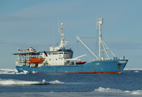
Photo: Norwegian Polar Institute/ S. Gerland
RV Lance, the research vessel chartered by Universität Hamburg, is now on its way to its Arctic research area off the east coast of Spitsberg. On board, researchers are testing ...
RV Lance, the research vessel chartered by Universität Hamburg, is now on its way to its Arctic research area off the east coast of Spitsberg. On board, researchers are testing for the first time a computer model for high-definition predictions for ice concentration and ice thickness. The journey is part of the joint IRO-2 (Ice-Routing Optimization) project, funded by the Federal Ministry for Economic Affairs and Energy (BMWi) and coordinated by the Hamburg Ship Model Basin (HSVA). The aim is to make safe passage for international shipping through the polar region possible.
Up to now, there has always been a major concern when crossing the Arctic Sea: Is the route free, or are there ice masses hindering safe travel? The IRO-2 project is intended to improve route planning for ships using a newly developed modeling system from Universität Hamburg’s Center for Earth System and Sustainability Research (CEN), which brings together forecasts for the ocean, ice and atmosphere. The meteorologist Björn Fock uses data on the overall ice conditions in the Arctic from the Hamburg companies FastOpt and O.A.Sys, which he then combines with atmospheric data from the European Centre for Medium-Range Weather Forecasts in Reading and data from the European Space Agency’s (ESA) SMOS satellite. “Based on this data, the new model generates a high-definition local forecast for the relevant ice conditions,” reports Fock. “Our model provides details on the concentration, the ice thickness and also on movement of the ice.” Twice a day, Fock sends an up-to-date forecast to colleagues at the HSVA. However, ice predictions are only the first step.
“Because ships change their position, the forecasts have to be continuously included in the route calculations,” explains engineer Peter Jochmann from the HSVA. Depending on the size and speed of the ship, various routes across the Arctic Ocean are possible. “Think of it like a traffic-jam warning system in a satnav, which measures the speed, calculates when the end of the traffic jam will be reached and then suggests either reducing speed or taking another route.” Route calculations for the Arctic Sea are similar. If, according to the model, the ship will encounter an ice mass in its path, an optimal speed will be recommended or an alternative route suggested. The program uses ice forecasts produced every fifteen minutes to find the best route; the forecasts are updated twice a day and sent to the research vessel in the Arctic Ocean.
There, the research crew of the RV Lance checks how accurately the predictions correspond to the actual conditions in the area. In addition, a team led by sea-ice expert Prof. Lars Kaleschke from the CEN takes remote sensing measurements. To do so, buoys are placed among the ice, allowing the drift speed to be measured. The Norwegian Polar Institute is also supporting the work on board the RV Lance: The team is using electromagnetic induction to determine the local ice thickness. Larger-scale data is provided by a research aircraft from the Alfred Wegener Institute for Polar and Marine Research, which also measures ice thickness using microwave radiation with a wavelength of 21 cm.
“Making the Arctic Ocean passable for civilian shipping is a complex undertaking, which can only be achieved if several partners work together,” says IRO-2 coordinator Peter Jochmann. In addition to the Hamburg Ship Model Basin, Universität Hamburg and the University of Bremen, the Alfred Wegener Institute for Polar and Marine Research, Ocean Atmosphere Systems GmbH, FastOpt GmbH, the National Space Institute of Technical University of Denmark, the Norwegian Polar Institute, the Federal Maritime and Hydrographic Agency, Joachim Schwarz Consulting and the European Space Agency are all involved in this major international project.
