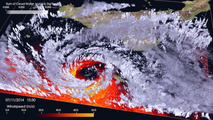
A tropical-like cyclone in the Mediterranean Sea
The video shows a 3-D representation of the cyclone using a volumetric rendering of clouds, obtained as sum of cloud water and cloud ice, followed by streamlines coloured according to windspeed.

A tropical-like cyclone in the Mediterranean Sea
The model is able to recreate the cyclonic structure, including the cloud-free region at the centre which appears larger than in reality. This is due to the volumetric opacity transfer function employed by the visualization method. The randomly seeded trajectories of air parcels show that there is strong convergence towards the center of the cyclone, with winds being substantially more intense in the southern flank of the system and calm in its center. The cold front preceding the cyclone formation is also visible as a sharp contrast of surface winds in the lower-right corner. Finally, it is interesting to note the presence of a subsiding trajectory in the center of the cyclone, as expected in tropical structures.
Tropical-Like Cyclones (TLCs) characterized by a symmetric structure formed by a central cloud-free region surrounded by deep convective clouds are known to form over the Mediterranean and have been documented since the satellite era began. In the latest 15 years they have drawn much attention because of the damages caused in coastal areas and gained the epithet of Mediterranean Tropical-Like Cyclones (MTLCs) or, in short, Medicanes for Mediterranean Hurricanes. Although MTLCs share many features of Tropical Cyclones they appear to be much smaller in radius (50 to 300 km) but still able to produce hurricane-force winds. They are originally of baroclinic nature and, under specific environmental conditions, undergo a phase of development that causes a transition to a tropical-like structure which often presents co-existing hybrid extra-tropical features. Conditions favourable to MTLCs genesis include, but are not limited to, the presence of an initial low-level disturbance, usually in the form of a Mean Sea-Level Pressure minimum, and of an upper-level cold through that contributes to increase the air-sea gradient of saturation moist static energy.
Reference: Cioni, G., Cerrai D. and Klocke D. (2017): Investigating the predictability of a Mediterranean Tropical-like Cyclone using a non-hydrostatic high-resolution model. Q. J. R. Met. S.
